SOHO
Manhattan
Geographic Setting
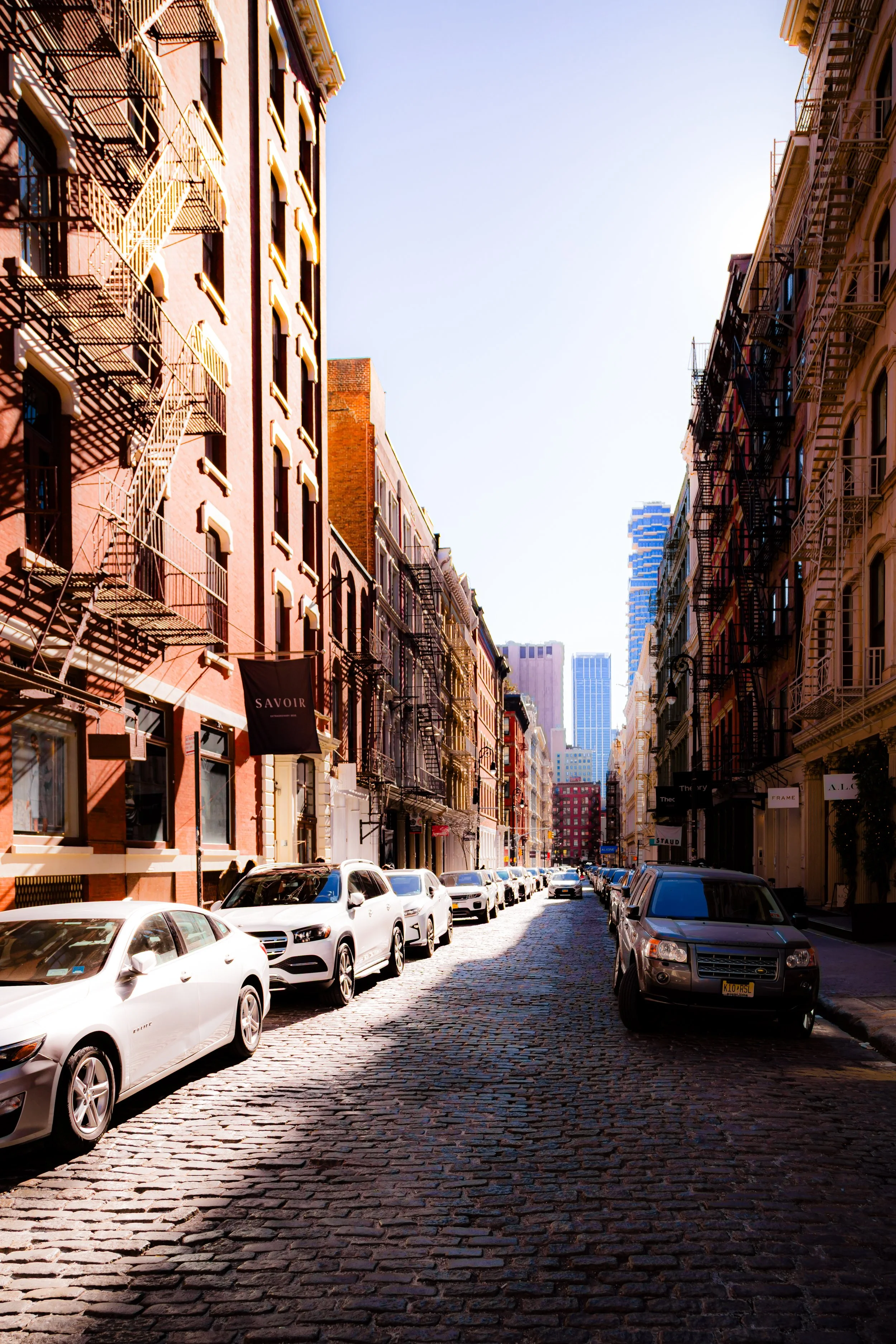
Bounded by Canal Street to the south and Houston Street to the north, and extending from Sixth Avenue (Avenue of the Americas) eastward to Lafayette Street, SoHo—short for “South of Houston”—is one of Manhattan’s most celebrated and visually distinctive neighborhoods. It lies at the crossroads of Lower Manhattan’s mercantile history and its artistic reinvention, its cobblestone streets and cast-iron façades forming a living museum of 19th-century urban design.
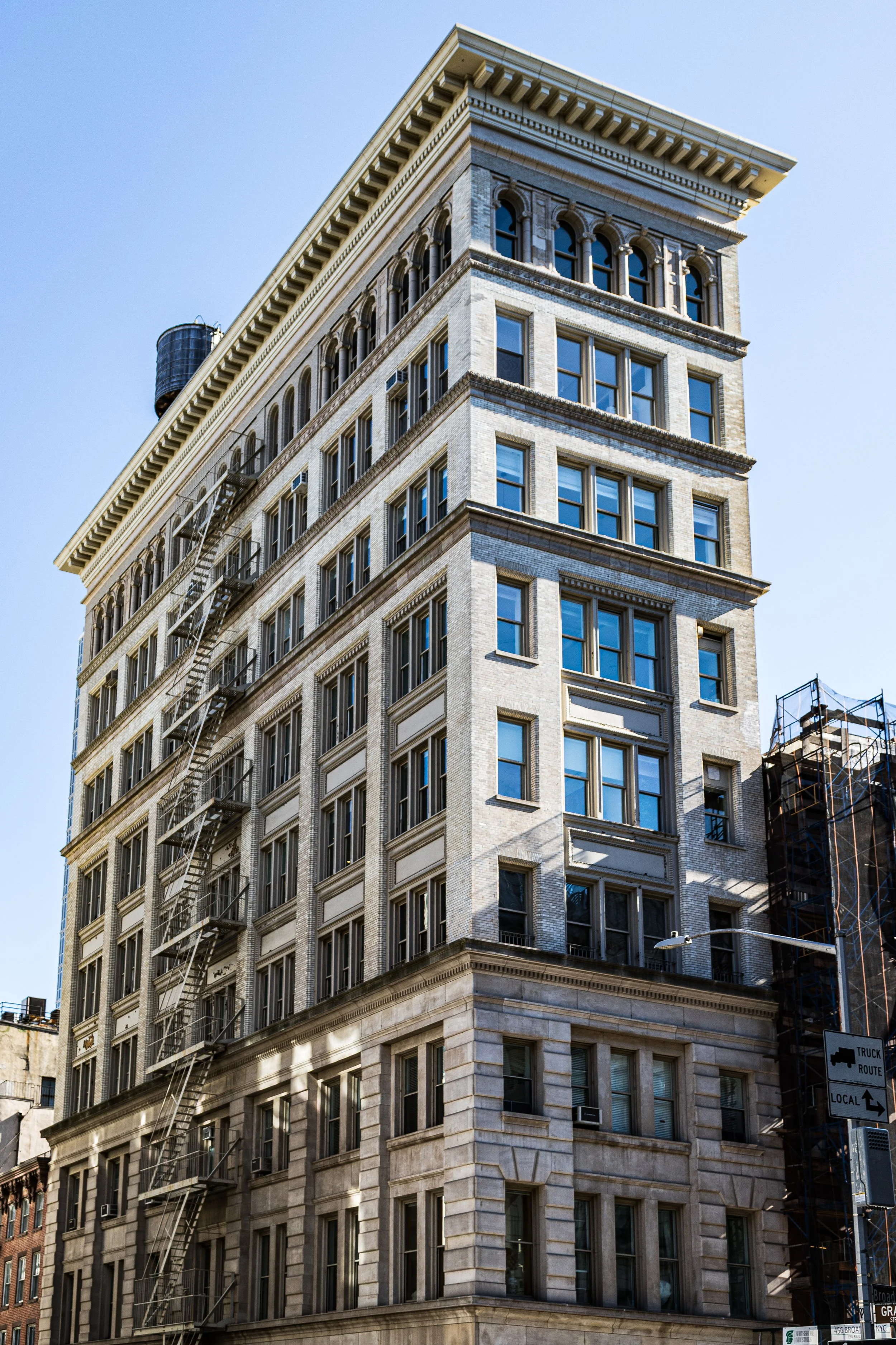
SoHo’s irregular grid—defined by Broome, Spring, Prince, Mercer, and Greene Streets—reveals its pre-grid origins as reclaimed farmland and tidal marsh. Its architecture, dominated by late-19th-century loft buildings with cast-iron fronts, Corinthian columns, and tall arched windows, forms the world’s largest concentration of cast-iron structures. The district’s westward rise along Sixth Avenue is lined with wider commercial blocks, while its eastern edge near Lafayette gives way to narrow, human-scaled lanes reminiscent of an older city. The neighborhood’s dual nature—grand yet intimate, industrial yet refined—has made it both a historic landmark and a global icon of urban style.
Etymology and Origins
The name “SoHo”, coined in 1962 by urban planner Chester Rapkin during a study of Lower Manhattan’s industrial zones, stands for South of Houston Street—a simple locational tag that became an enduring brand. The acronym, inspired by the London district of Soho, emerged in the early 1970s when artists and preservationists sought to distinguish the area from the declining garment and warehouse zones surrounding it.
Before its modern rebirth, the land that became SoHo was part of Collect Pond’s drainage basin in the 18th century, an area of creeks and pasture owned by Dutch and English settlers. In the early 1800s, landfill and the Commissioners’ Plan of 1811 extended Manhattan’s grid south to Canal Street, paving the way for development. By mid-century, the district had become a fashionable residential and commercial quarter, centered on Broadway—then New York’s most prestigious shopping street.
The Neighborhood
19th Century: From Fashionable Row to Industrial Core
In the 1820s and 1830s, SoHo (then known simply as part of Lower Manhattan or “South Fifth Ward”) was a neighborhood of wealth and elegance. Federal- and Greek Revival–style rowhouses lined Spring, Broome, and Mercer Streets, their owners drawn to proximity with the theaters, hotels, and carriage trade along Broadway. By the 1850s, however, as the elite moved uptown toward Union Square and Madison Square, commerce took over. The transformation was rapid and architectural: narrow homes were replaced by grand loft buildings, their façades crafted in cast iron—a new technology that allowed intricate ornament at low cost and could be molded off-site and bolted together on location.
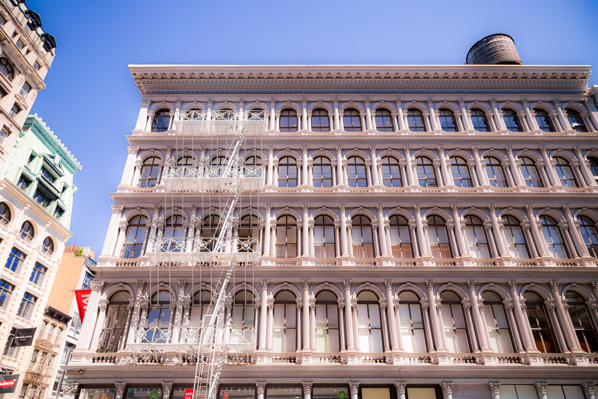
Architects such as John B. Snook, Griffith Thomas, Isaiah Rogers, and Henry Fernbach gave SoHo its enduring visual identity: rhythmic pilasters, fluted columns, and vast windows that flooded interiors with light. Notable examples include the Haughwout Building (1857) at Broadway and Broome—one of the earliest cast-iron masterpieces, designed by John Gaynor—and the E. V. Haughwout & Co. emporium, which introduced one of the world’s first passenger elevators. By the 1870s, SoHo was the city’s premier dry-goods and textile district, filled with showrooms, warehouses, and loft factories.
The hum of sewing machines and clatter of delivery wagons defined the neighborhood’s daily rhythm, while Broadway glittered with gaslights, marble façades, and the buzz of commerce. Yet behind the grandeur, working conditions were harsh, presaging the labor struggles that would later reshape American industry.
Early 20th Century: Decline and Industrial Reuse
By the early 1900s, SoHo’s commercial heyday had waned. As new skyscrapers rose in Midtown and manufacturing migrated uptown or to the outer boroughs, the neighborhood settled into a quieter role as a warehouse and light-manufacturing zone. The once-grand lofts were repurposed for printing, storage, and small-scale production—metalworking, textiles, and later plastics.
The 1910s–1930s saw architectural stability but economic stagnation. The district became known as part of the “Cast-Iron District,” though by midcentury it was often referred to pejoratively as “Hell’s Hundred Acres”—a term coined by fire officials to describe the labyrinth of old buildings filled with flammable goods and outdated wiring. Yet this very underuse would later preserve SoHo’s historic fabric: lacking large-scale redevelopment, its 19th-century architecture survived almost untouched.
Through the 1940s and 1950s, Italian and Puerto Rican families ran small shops and workshops here, while the Bowery to the east housed transient hotels and missions. The neighborhood, though diminished, remained alive—a working district rather than an abandoned one.
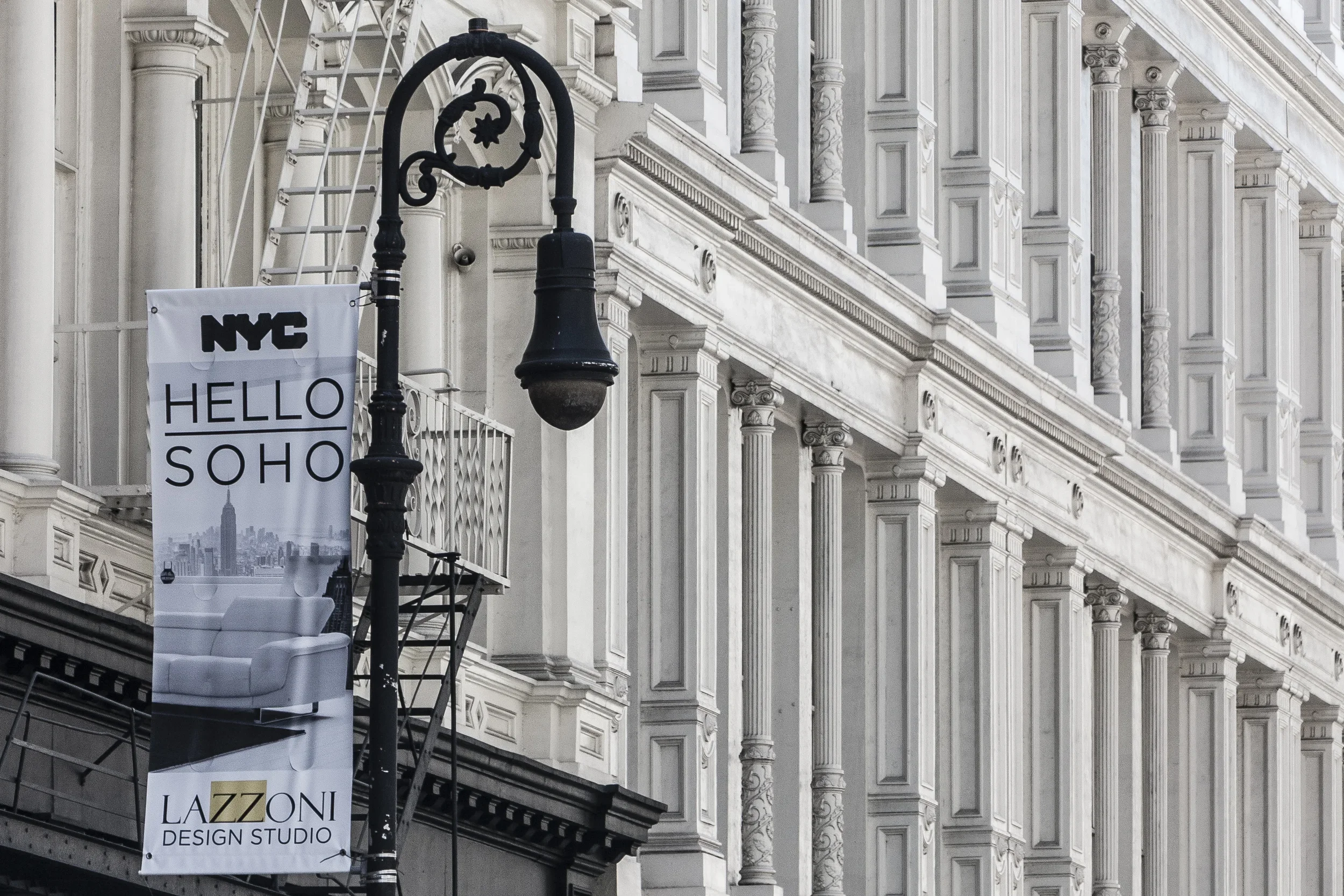
SoHo Photographic Tour
Mid–Late 20th Century: Artists, Preservation, and Renaissance
The transformation of SoHo from industrial relic to cultural landmark began in the 1960s, when artists discovered its vast, inexpensive lofts. Painters, sculptors, and photographers—including Donald Judd, Chuck Close, Louise Nevelson, and Agnes Martin—moved into the disused spaces, converting them into studios and live-work lofts. Though these conversions were technically illegal under manufacturing zoning, the city tolerated them, and the SoHo Artists Association (founded 1968) began advocating for legal recognition.
Urban planner Chester Rapkin’s 1962 report for the Department of City Planning had already highlighted SoHo’s architectural coherence and potential for adaptive reuse. His insights laid the groundwork for the 1971 Artist-in-Residence (A.I.R.) zoning law, which legalized live-work lofts for certified artists. Around the same time, preservationists successfully resisted plans for the proposed Lower Manhattan Expressway, a Robert Moses project that would have cut a swath through SoHo and Little Italy. Their victory preserved not only a neighborhood but one of the most complete 19th-century urban landscapes in the world.
By the 1970s and 1980s, SoHo had become synonymous with avant-garde culture. Galleries like Paula Cooper, Leo Castelli, and OK Harris opened in converted factories, while minimalist and conceptual art movements flourished in the district’s open floors and high ceilings. SoHo’s cast-iron lofts, once industrial, became temples of modern art. In 1973, the SoHo Cast-Iron Historic District was officially designated, protecting roughly 26 blocks of architecture built between 1840 and 1895.
21st Century: The Global Village of Art, Fashion, and Design
By the late 1990s and into the 21st century, SoHo had completed its metamorphosis into one of the world’s most desirable urban neighborhoods. The art galleries migrated north to Chelsea, but design studios, fashion houses, and high-end boutiques replaced them, turning the area into an international shopping and cultural destination. The same lofts that once housed factories and artists’ studios now serve as flagship stores, creative offices, and multimillion-dollar residences.
Yet SoHo retains traces of its layered past. Cobblestone streets—Greene, Mercer, Wooster, Crosby—still echo with the rumble of delivery trucks and the footsteps of visitors photographing its ornate façades. The Drawing Center, New York City Fire Museum, and Angelika Film Center sustain its cultural edge, while the adaptive reuse of buildings like E. V. Haughwout & Co., Gunther Building, and Little Singer Building showcase preservation as living practice. New architecture, such as Jean Nouvel’s 40 Mercer Street and Herzog & de Meuron’s 160 Leroy Street nearby, reflects SoHo’s continuing dialogue between industrial heritage and contemporary design.
Despite gentrification, the district’s physical integrity remains remarkably intact—its proportions, materials, and streetscapes protected by landmark status and by the sheer charisma of its architecture.
SoHo Photo Gallery
Spirit and Legacy
SoHo’s story is a parable of New York itself—decline redeemed through creativity, industry reborn as art. Few neighborhoods anywhere embody such a seamless layering of urban epochs: mercantile splendor, industrial toil, artistic rebellion, and cosmopolitan affluence. Its cast-iron façades, once purely utilitarian, now symbolize the city’s genius for adaptation.
New York City
Use this custom Google map to explore where every neighborhood in all five boroughs of New York City is located.
The Five Boroughs
One of New York City’s unique qualities is its organization in to 5 boroughs: Manhattan, Brooklyn, Queens, The Bronx, and Staten Island. These boroughs are part pragmatic administrative districts, and part vestiges of the region’s past. Each borough is an entire county in New York State - in fact, Brooklyn is, officially, Kings County, while Staten Island is, officially Richmond County. But that’s not the whole story …
Initially, New York City was located on the southern tip of Manhattan (now the Financial District) that was once the Dutch colony of New Amsterdam. Across the East River, another city was rising: Brooklyn. In time, the city planners realized that unification between the rapidly rising cities would create commercial and industrial opportunities - through streamlined administration of the region.
So powerful was the pull of unification between New York and Brooklyn that three more counties were pulled into the unification: The Bronx, Queens, and Staten Island. And on January 1, 1898, the City of New York unified two cities and three counties into one Greater City of New York - containing the five boroughs we know today.
But because each borough developed differently and distinctly until unification, their neighborhoods likewise uniquely developed. Today, there are nearly 390 neighborhoods, each with their own histories, cultures, cuisines, and personalities - and each with residents who are fiercely proud of their corner of The Big Apple.


