OLD HOWARD BEACH
Queens
Geographic Setting
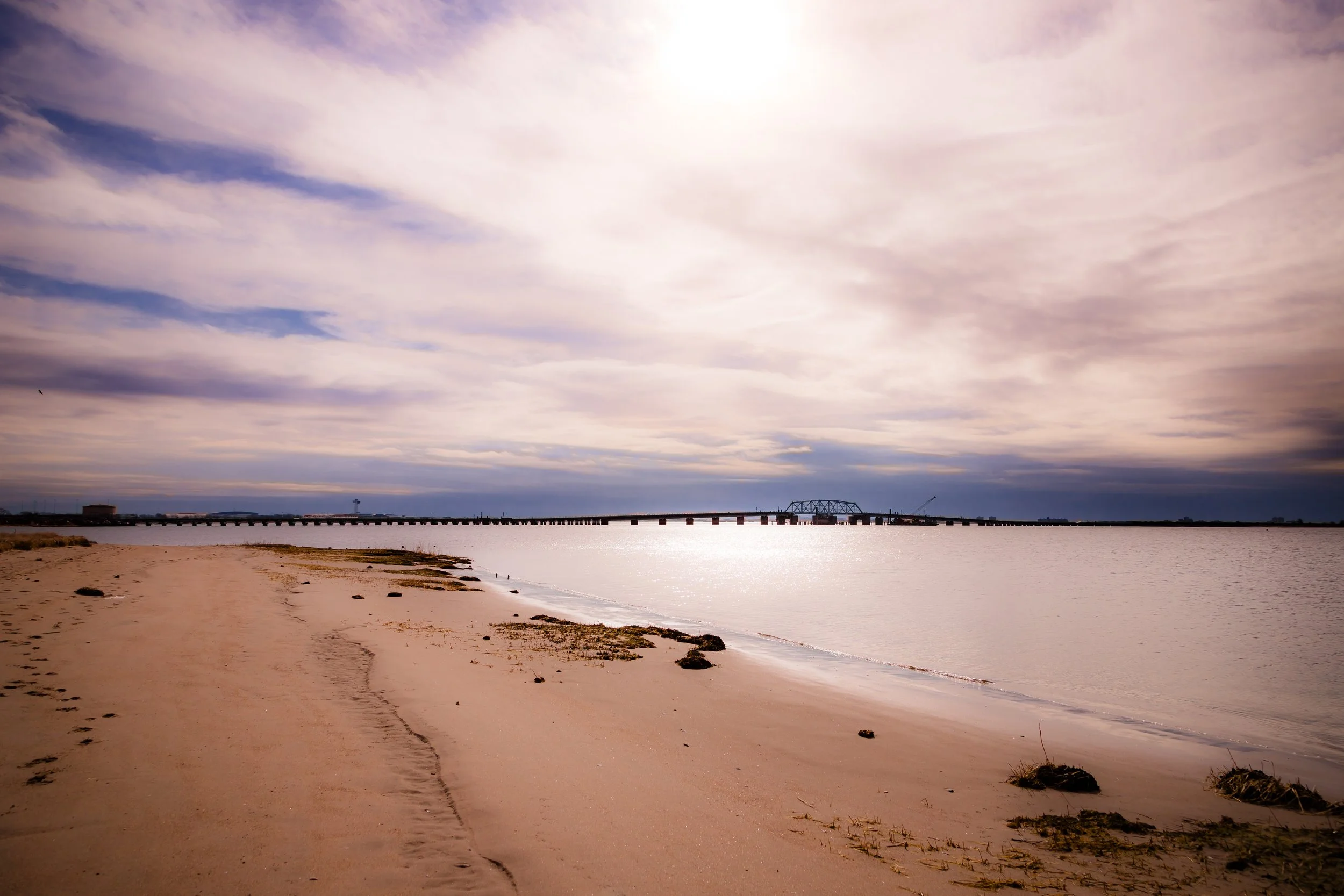
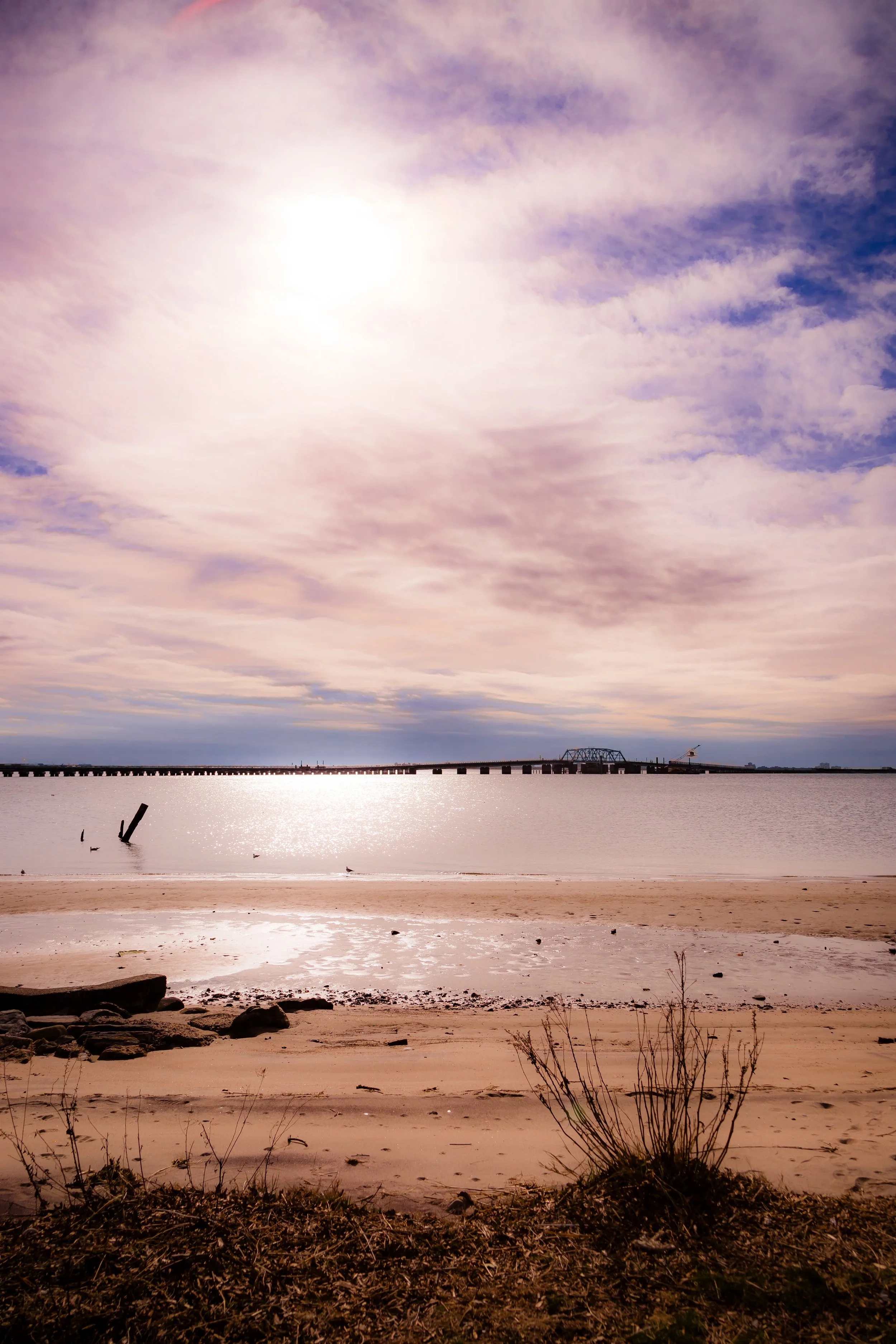
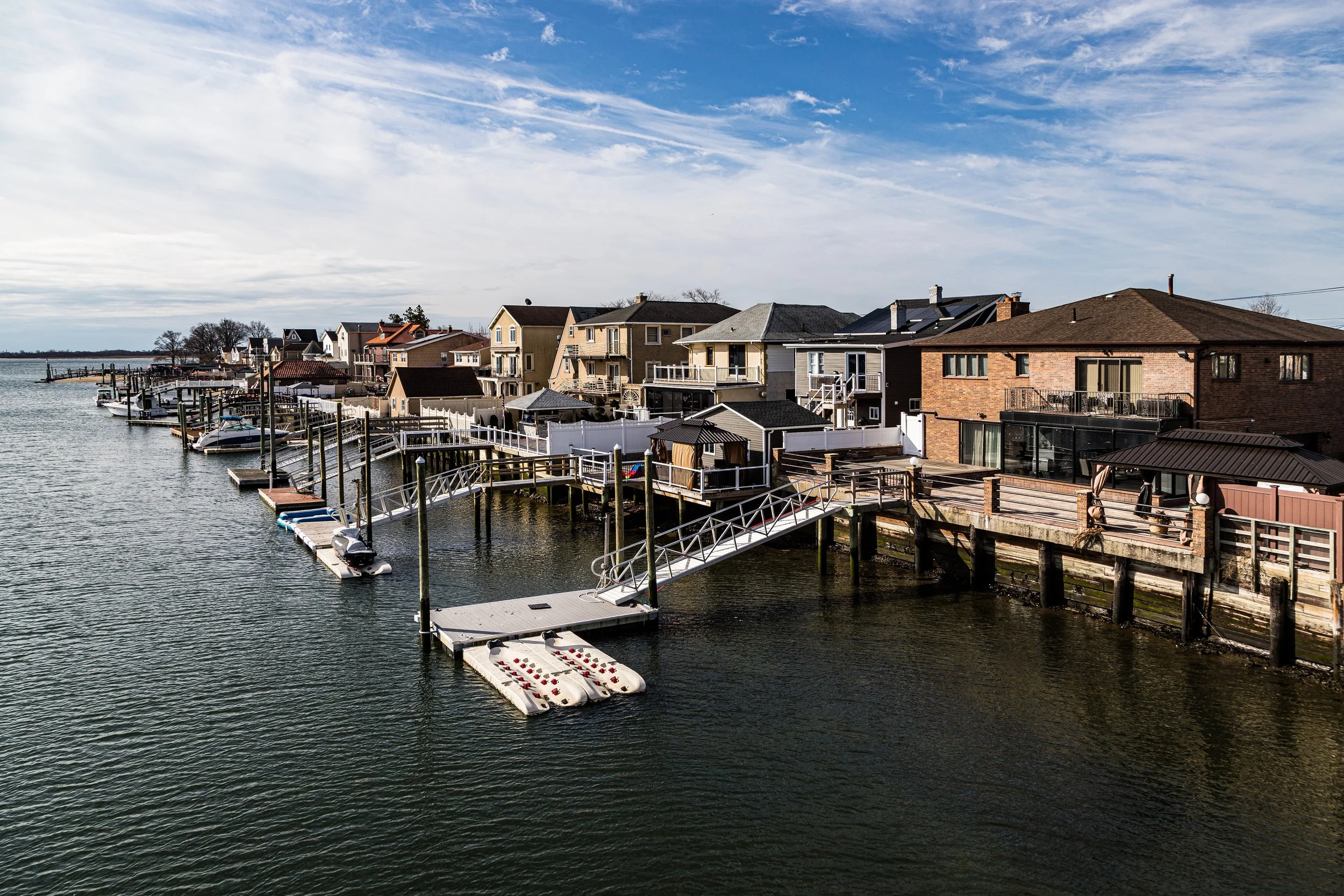
Bounded by the Belt Parkway to the north, 103rd Street to the east, Hawtree Creek to the southeast, Jamaica Bay to the south, and Shellbank Basin to the west, Old Howard Beach forms the original heart of the broader Howard Beach community—a low-lying, waterfront enclave that blends the intimacy of a small seaside town with the traditions of New York’s classic outer-borough neighborhoods. Tucked along the northwestern edge of Jamaica Bay, this section of Howard Beach lies between the marshlands of Hawtree Basin and the sheltered inlets of Shellbank Creek, its streets following a rhythmic pattern of narrow residential lanes, canals, and small bridges that recall the area’s origins as a resort-by-the-bay.
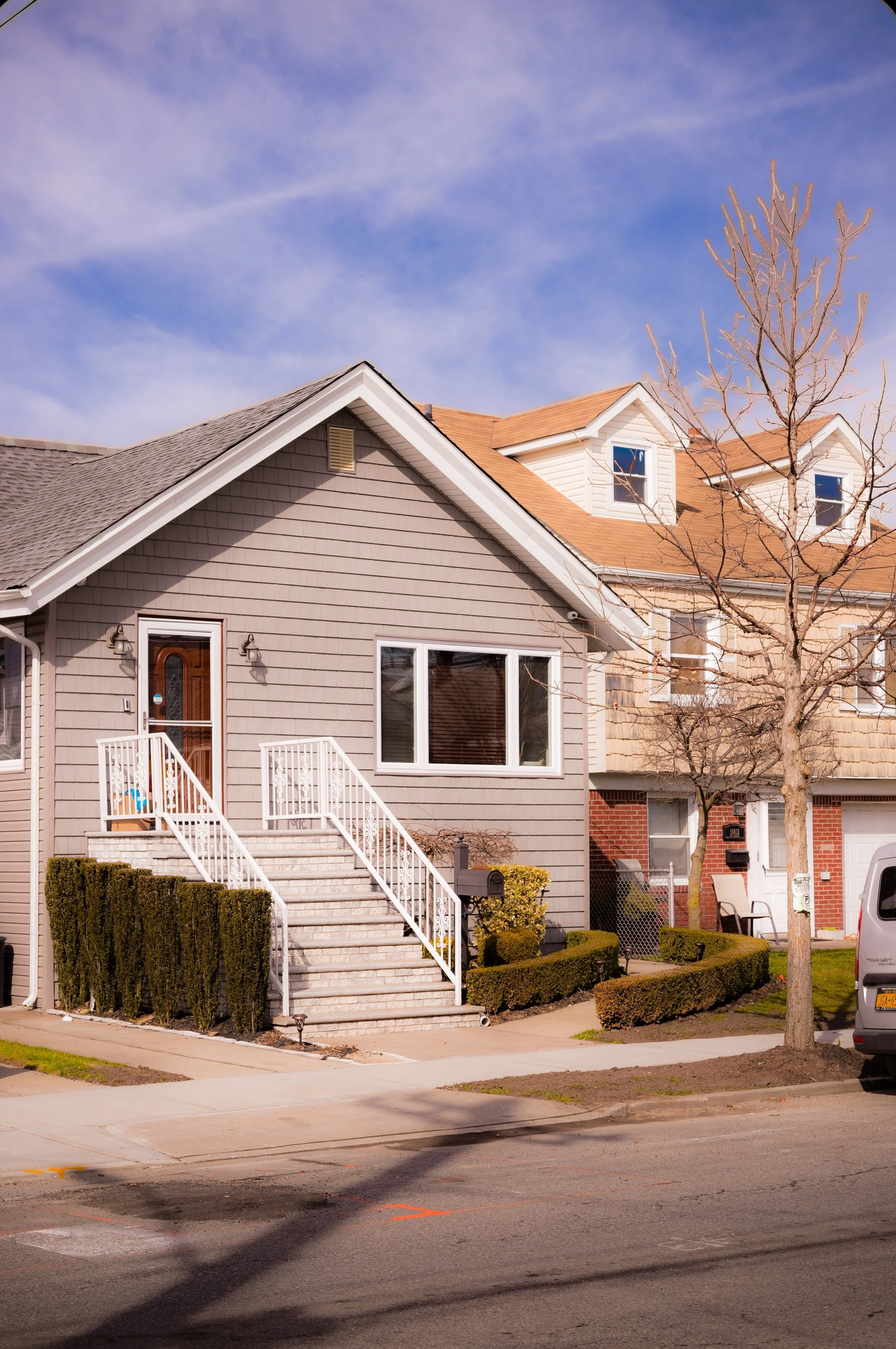
The neighborhood’s geography is defined by its proximity to water. Long blocks of tidy bungalows, brick Cape Cods, and split-level homes sit just above sea level, many with backyards that open directly onto inlets and docks. Cross Bay Boulevard serves as its central artery, connecting Old Howard Beach to Lindenwood, New Howard Beach, and the Rockaway Peninsula beyond. The community’s spatial intimacy—punctuated by gardens, fences, and small marinas—fosters a deep sense of place: maritime, family-oriented, and unmistakably Queens.
Etymology and Origins
The name “Howard Beach” originates from William J. Howard, a Brooklyn-based glove manufacturer who, in 1897, purchased land along the western edge of Jamaica Bay and began developing it as a recreational seaside resort. Howard built a network of canals, piers, and cottages, envisioning a bayside retreat for New Yorkers seeking weekend leisure within reach of the city. The original section of this development—what is now called Old Howard Beach—occupied the land between Shellbank Basin and Hawtree Creek, adjacent to the then-undeveloped marshlands of Broad Channel and Spring Creek.
In the early 1900s, Howard constructed the Hawtree Creek Bridge, linking the area to Cross Bay Boulevard, and promoted the community as a blend of “country and sea”—accessible by the Long Island Rail Road and later by trolleys that ran through Ozone Park. Early residents built summer bungalows and fishing cottages, many on pilings above tidal flats. With its small canals and intimate scale, the area earned comparisons to “a little Venice in Queens.”
After Howard’s death in 1909, development continued under private builders, who marketed the neighborhood as an affordable retreat for working- and middle-class families. Over time, “Old Howard Beach” came to refer specifically to the earliest section north of the Hawtree and Shellbank Basins, distinguishing it from later 20th-century expansions such as New Howard Beach and Hamilton Beach.
The Neighborhood
Early–Mid 20th Century: From Resort to Residential Haven
By the 1920s and 1930s, Old Howard Beach had shifted from a seasonal resort to a year-round residential neighborhood. The extension of Cross Bay Boulevard (1925) and the construction of the Jamaica Bay Bridge (1939) connected the area more firmly to the rest of Queens, while landfilling projects elevated portions of the marshland to make permanent housing possible. Wooden bungalows gave way to brick Cape Cods, stucco cottages, and semi-detached homes built in the interwar years.
Community institutions emerged alongside this growth. St. Helen’s Roman Catholic Church (founded in 1929) became the neighborhood’s spiritual center, while local businesses clustered around Cross Bay Boulevard, forming a self-contained main street. Schools, playgrounds, and civic associations reinforced the area’s family-centered ethos.
During the post–World War II housing boom, returning veterans and upwardly mobile families from Brooklyn and Manhattan settled here, drawn by affordable homes, good schools, and proximity to the water. The completion of the Belt Parkway (1940) further connected Old Howard Beach to the metropolitan highway network, turning the neighborhood into a quintessential example of mid-century suburban life within the city—complete with driveways, lawns, and a strong emphasis on homeownership.
By the 1950s and 1960s, Old Howard Beach had established its identity as a stable, predominantly Italian- and Irish-American community defined by neighborhood pride, close-knit families, and multigenerational continuity.
Late 20th Century: Stability, Identity, and the Challenges of the Bay
Throughout the latter half of the 20th century, Old Howard Beach maintained remarkable stability even as much of New York City changed around it. While the larger city experienced waves of urban decline and renewal, this enclave remained largely insulated—its combination of low-rise homes, high ownership rates, and strong community ties preserving its suburban tone. Cross Bay Boulevard continued to serve as the neighborhood’s main commercial strip, home to pizzerias, bakeries, hardware stores, and small family-run restaurants that became local landmarks.
The area’s proximity to Jamaica Bay, however, brought environmental and infrastructural challenges. Occasional flooding from high tides and storms—especially during the 1970s and 1980s—spurred community advocacy for better drainage and shoreline protection. Local groups such as the Old Howard Beach Civic Association and New York Rising Community Reconstruction Program worked with the city to improve bulkheads, seawalls, and pumping systems.
Despite these challenges, the neighborhood retained a strong sense of identity—characterized by its patriotism, traditional values, and continuity of family life. Many homes passed from one generation to the next, while neighborhood events like block parties, church festivals, and parades reinforced a collective sense of belonging.
Old Howard Beach Video Coming Soon
21st Century: Resilience, Renewal, and Enduring Community
The 21st century has tested Old Howard Beach’s resilience, most notably during Hurricane Sandy (2012), which inundated the area with floodwaters from Jamaica Bay. Many homes were damaged or destroyed, and residents faced months of recovery. Yet the response from the community reflected its historic strength: neighbors helped neighbors rebuild, civic groups organized relief drives, and within a few years, the neighborhood had largely restored itself. Post-Sandy rebuilding brought elevated homes, new seawalls, and updated infrastructure designed to mitigate future storms.
Today, Old Howard Beach remains a tight-knit, predominantly homeowner community, though it has grown more diverse in recent decades, welcoming Caribbean-, South Asian-, and Hispanic-American families alongside long-established residents. The neighborhood’s schools, parks, and waterfront views continue to attract families seeking peace and space within reach of the city’s center.
Charles Memorial Park, along the waterfront, provides recreational access to Jamaica Bay and stands as a reminder of the area’s enduring connection to nature and the sea. On weekends, residents stroll along the water’s edge or fish from docks that recall the community’s earliest days as a seaside village.
Old Howard Beach Photo Gallery
Spirit and Legacy
Old Howard Beach’s legacy is one of continuity and resilience. Born as a bayside resort, matured as a working- and middle-class suburb, and tested by nature’s force, it has preserved a spirit of self-reliance, loyalty, and pride. Its canals and inlets, its flags and front porches, and its enduring sense of neighborhood identity make it one of Queens’ most distinctive and cohesive enclaves.
New York City
Use this custom Google map to explore where every neighborhood in all five boroughs of New York City is located.
The Five Boroughs
One of New York City’s unique qualities is its organization in to 5 boroughs: Manhattan, Brooklyn, Queens, The Bronx, and Staten Island. These boroughs are part pragmatic administrative districts, and part vestiges of the region’s past. Each borough is an entire county in New York State - in fact, Brooklyn is, officially, Kings County, while Staten Island is, officially Richmond County. But that’s not the whole story …
Initially, New York City was located on the southern tip of Manhattan (now the Financial District) that was once the Dutch colony of New Amsterdam. Across the East River, another city was rising: Brooklyn. In time, the city planners realized that unification between the rapidly rising cities would create commercial and industrial opportunities - through streamlined administration of the region.
So powerful was the pull of unification between New York and Brooklyn that three more counties were pulled into the unification: The Bronx, Queens, and Staten Island. And on January 1, 1898, the City of New York unified two cities and three counties into one Greater City of New York - containing the five boroughs we know today.
But because each borough developed differently and distinctly until unification, their neighborhoods likewise uniquely developed. Today, there are nearly 390 neighborhoods, each with their own histories, cultures, cuisines, and personalities - and each with residents who are fiercely proud of their corner of The Big Apple.


