STUYVESANT HEIGHTS
Brooklyn
Geographic Setting
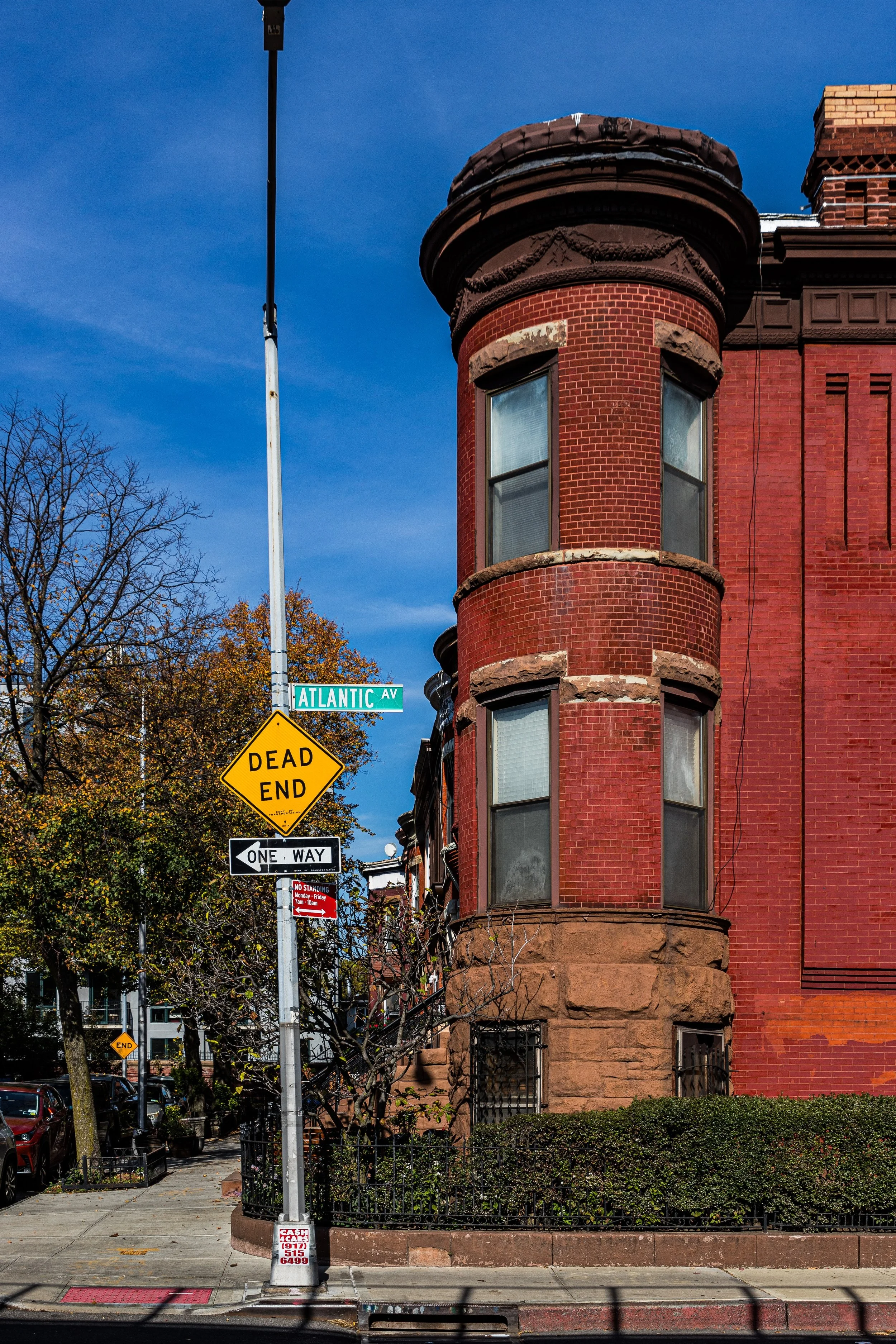
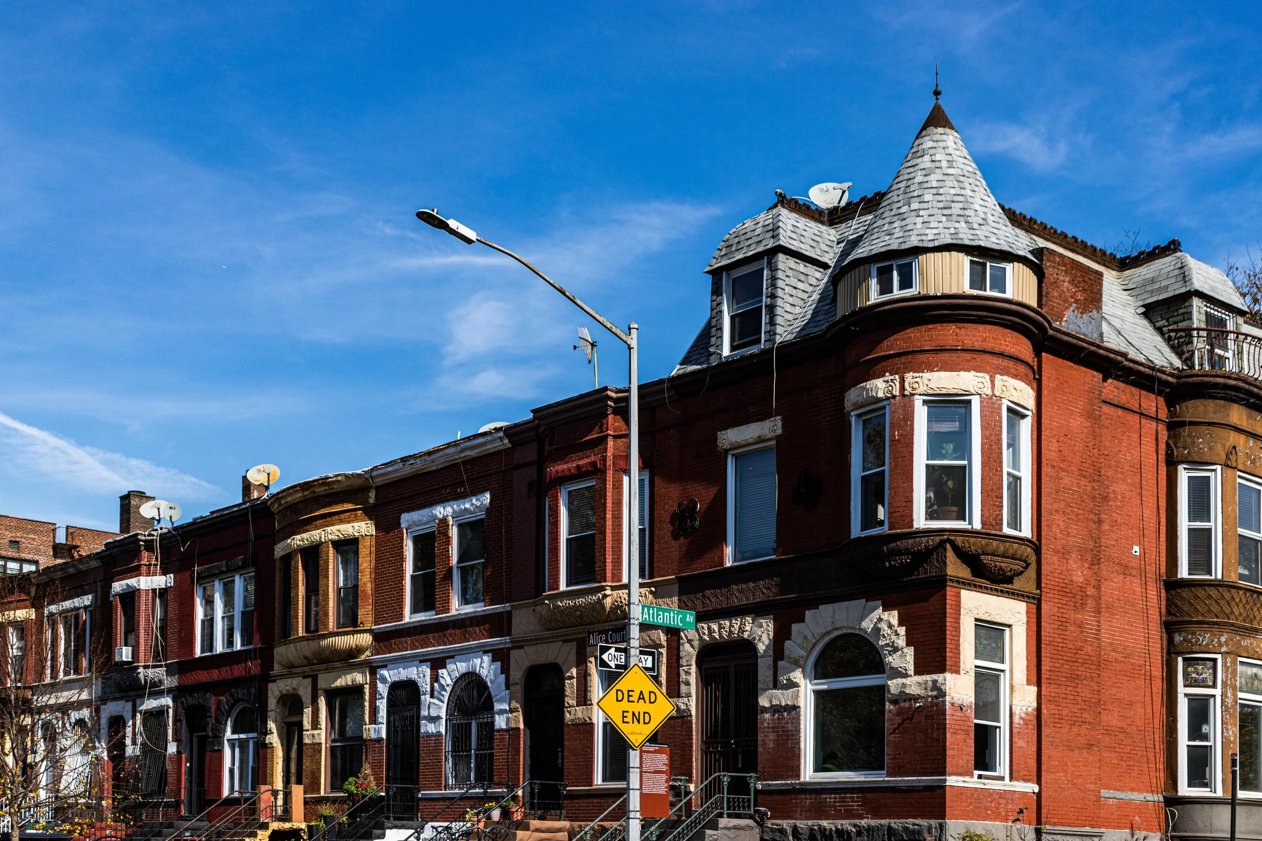
Bounded by Tompkins Avenue to the west, Malcolm X Boulevard (formerly Reid Avenue) to the east, a southern border primarily along Fulton Street, and a northern edge traced by Macon, Halsey, and Hancock Streets, Stuyvesant Heights occupies the historic heart of Bedford–Stuyvesant, one of Brooklyn’s most architecturally intact and culturally storied districts. Its gently graded streets unfold in a perfect brownstone rhythm—rows of 19th-century townhouses, limestone façades, and cast-iron railings under mature trees that arch into leafy tunnels each summer.
The neighborhood sits atop a rise that historically overlooked the flatlands stretching toward Bushwick and East New York. Today, Stuyvesant Avenue, Lewis Avenue, and MacDonough Street form the area’s most picturesque corridors, where uniform stoops and intact cornices reflect the ambitions of Brooklyn’s late Victorian urban planners. Along Fulton Street, commerce still hums—grocers, cafés, and century-old storefronts serving both longtime residents and new arrivals—while Marcus Garvey Boulevard, one block west of the border, links the district southward to Crown Heights and northward to the wider Bed-Stuy landscape. Stuyvesant Heights remains a quintessential expression of brownstone Brooklyn: residential yet urban, elegant yet grounded.
Etymology and Origins
The neighborhood takes its name from Peter Stuyvesant, the last Dutch Director-General of New Netherland (1655–1664), whose family owned extensive tracts of land across what became Manhattan and Brooklyn. The “Heights” refers not to a dramatic elevation but to the subtle rise in terrain that made this section of Bedford one of the more desirable residential developments of the late 19th century.
Originally, the area formed part of the Town of Bedford, one of Brooklyn’s earliest settlements, established in the late 1600s. For nearly two centuries, it remained semi-rural—its landscape dotted with Dutch farmhouses, woodlots, and narrow lanes connecting to the villages of Flatbush and Bushwick. The arrival of horsecar lines along Fulton Street in the 1850s and later the elevated railway (1888) transformed the district almost overnight from farmland to suburb, drawing an emerging middle class of merchants and professionals seeking refined housing within easy reach of downtown Brooklyn.
The Neighborhood
19th Century: A Brownstone Ideal
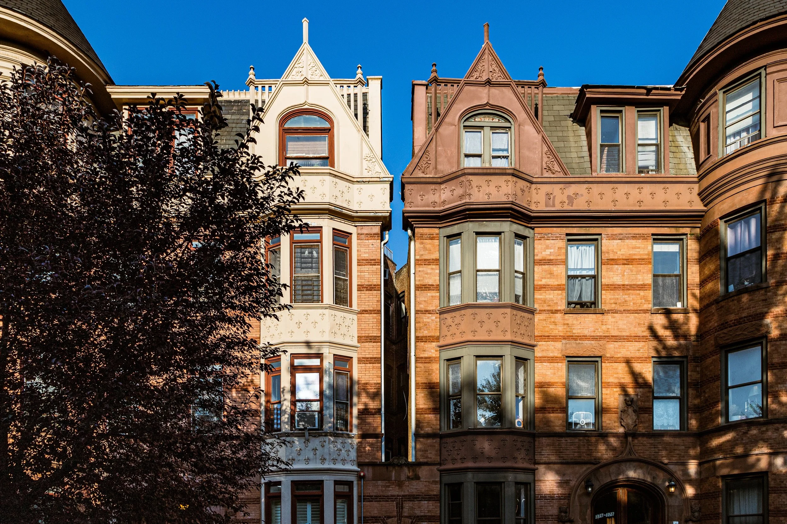
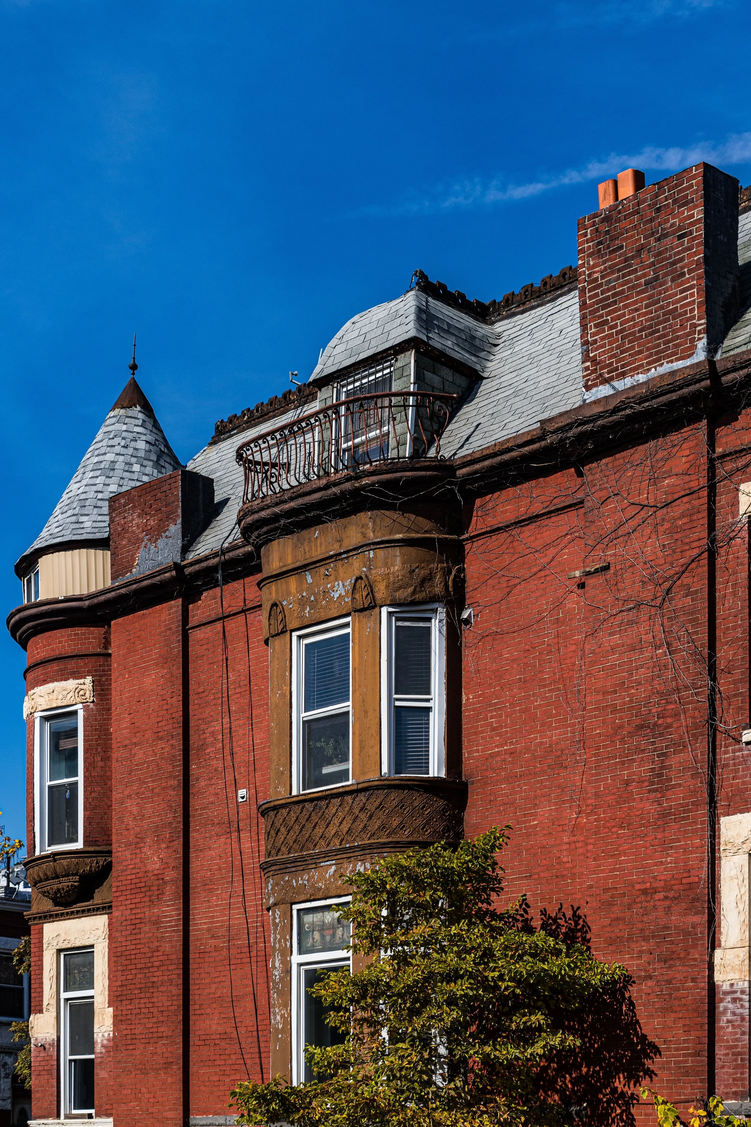
Between the 1870s and early 1900s, Stuyvesant Heights experienced its great building boom. Developers, guided by the example of Brooklyn Heights and Clinton Hill, sought to create a self-contained residential district marked by architectural harmony and civic respectability. Blocks such as MacDonough, Hancock, and Decatur Streets filled with rowhouses in Italianate, Neo-Grec, Queen Anne, and Romanesque Revival styles, designed by architects including Magnus Dahlander, Langston & Dahlander, and George Poole Chappell.
The hallmark of Stuyvesant Heights architecture was detail: high stoops, brownstone lintels, carved newels, and ornamental cornices, combined in endless variation. The resulting streetscapes were cohesive yet never monotonous—a balance that remains one of the neighborhood’s visual signatures. Wealthier residents occupied the larger mansions near Stuyvesant Avenue and Lewis Avenue, while clerks and artisans filled the narrower side streets.
The completion of the Stuyvesant Heights Congregational Church (1887) and the Our Lady of Victory Roman Catholic Church (1895) symbolized the area’s maturity as a genteel suburb within the city. Its population was largely German, Irish, and Jewish, later joined by Italian and Eastern European families. With the advent of the Brooklyn Bridge (1883) and the consolidation of Greater New York (1898), Stuyvesant Heights became a firmly established middle-class enclave—“a district of quiet refinement,” as the Brooklyn Daily Eagle described it in 1892.
Early–Mid 20th Century: Transition and the Great Migration
The early 20th century brought demographic and social transformation. As Manhattan’s African American population grew during the Great Migration, families seeking better housing and opportunity began moving across the East River. In the 1920s–1940s, Black residents from Harlem and the American South, along with West Indian immigrants from Barbados, Jamaica, and Trinidad, gradually replaced the earlier European populations, establishing one of the most vibrant Black communities in New York.
Stuyvesant Heights became part of the larger Bedford–Stuyvesant district—eventually synonymous with Black cultural and political life in Brooklyn. Churches such as Our Lady of Victory and St. Philip’s Episcopal Church welcomed new congregations, while Black-owned businesses, beauty parlors, and jazz clubs flourished along Fulton Street and Tompkins Avenue. The brownstones that had once symbolized white middle-class aspiration now became the architectural backdrop for a new chapter of urban identity—one defined by resilience, creativity, and self-determination.
By the 1950s–1960s, the area was majority Black, home to a robust working and middle class but also facing disinvestment and redlining. The city’s neglect of housing and infrastructure, coupled with predatory lending and absentee landlords, led to property decline. Yet amid hardship, community solidarity deepened. Block associations, church networks, and civic leaders—including Shirley Chisholm, the nation’s first Black congresswoman (elected in 1968 from this very district)—emerged from Stuyvesant Heights’ streets.
Stuyvesant Heights Video Coming Soon
Late 20th Century: Preservation and Renewal
During the 1970s–1980s, while much of New York faced fiscal crisis, Stuyvesant Heights’ residents mobilized to preserve their neighborhood’s physical and cultural heritage. Community organizations such as the Bedford–Stuyvesant Restoration Corporation—the first community development corporation in the nation—invested in housing rehabilitation, youth programs, and business assistance. Many residents purchased and restored brownstones abandoned during earlier decades, initiating a grassroots revival.
In 1971, the Stuyvesant Heights Historic District was designated by the New York City Landmarks Preservation Commission, recognizing more than 400 buildings of architectural significance between Tompkins Avenue, Stuyvesant Avenue, Macon Street, and Decatur Street. This designation not only protected the neighborhood’s aesthetic legacy but also affirmed its importance in the broader story of Black urban achievement and cultural identity.
Through the 1990s, new homeowners—many African American professionals and artists—continued to restore homes, even as gentrification pressures began to mount. Block associations remained vital forces, organizing cleanups, tree plantings, and cultural festivals that celebrated both history and community pride.
21st Century: Gentrification and Cultural Continuity
In the 21st century, Stuyvesant Heights stands at the intersection of preservation and transformation. The neighborhood’s architectural grandeur and proximity to downtown Brooklyn have attracted new waves of residents—young professionals, artists, and families—drawn by its historic charm and brownstone beauty. Cafés, art galleries, and boutique shops now line portions of Lewis and Tompkins Avenues, while long-standing barbershops, churches, and Caribbean restaurants continue to anchor the community.
The influx of wealth and investment has revived property values but also provoked concerns about displacement and cultural erasure. Yet Stuyvesant Heights remains distinct from many gentrified Brooklyn enclaves: its deep-rooted civic culture, anchored by generations of Black homeowners, block associations, and churches, continues to define its spirit. The Stuyvesant Heights Neighborhood Association, established in 1957, remains active in preserving both architecture and equity.
Today, the district balances the elegance of its 19th-century brownstones with the dynamism of 21st-century Brooklyn life. The soundscape blends gospel choirs, jazz on stoops, and the chatter from new cafés on Halsey Street. From the Sunday bustle around Our Lady of Victory Church to the laughter of children in St. Andrew’s Playground, Stuyvesant Heights endures as a living community—vibrant, evolving, and deeply proud.
Stuyvesant Heights Photo Gallery
Spirit and Legacy
The spirit of Stuyvesant Heights is one of resilience, refinement, and rootedness. Its brownstones are more than architecture—they are vessels of memory, containing the layered histories of Brooklyn’s builders, dreamers, and activists. The neighborhood embodies the continuity between past and present: Dutch farmlands to brownstone suburb, middle-class retreat to Black cultural stronghold, and now, a living dialogue between preservation and progress.
New York City
Use this custom Google map to explore where every neighborhood in all five boroughs of New York City is located.
The Five Boroughs
One of New York City’s unique qualities is its organization in to 5 boroughs: Manhattan, Brooklyn, Queens, The Bronx, and Staten Island. These boroughs are part pragmatic administrative districts, and part vestiges of the region’s past. Each borough is an entire county in New York State - in fact, Brooklyn is, officially, Kings County, while Staten Island is, officially Richmond County. But that’s not the whole story …
Initially, New York City was located on the southern tip of Manhattan (now the Financial District) that was once the Dutch colony of New Amsterdam. Across the East River, another city was rising: Brooklyn. In time, the city planners realized that unification between the rapidly rising cities would create commercial and industrial opportunities - through streamlined administration of the region.
So powerful was the pull of unification between New York and Brooklyn that three more counties were pulled into the unification: The Bronx, Queens, and Staten Island. And on January 1, 1898, the City of New York unified two cities and three counties into one Greater City of New York - containing the five boroughs we know today.
But because each borough developed differently and distinctly until unification, their neighborhoods likewise uniquely developed. Today, there are nearly 390 neighborhoods, each with their own histories, cultures, cuisines, and personalities - and each with residents who are fiercely proud of their corner of The Big Apple.


