VICTORIAN FLATBUSH / DITMAS PARK
Brooklyn
Geographic Setting
Bounded by Foster Avenue to the south, Coney Island Avenue to the west, Cortelyou Road to the northwest, and Ocean Avenue to the east, Ditmas Park—the heart of the greater Victorian Flatbush district—is one of New York City’s most distinctive residential enclaves. Its wide, tree-lined avenues, freestanding wood-frame houses, and lush lawns evoke the look and spirit of an American suburb, yet it lies only seven miles from Times Square. Within this rectangle of southern Brooklyn, gables and turrets replace brownstones, porches replace stoops, and architectural exuberance flourishes where the city’s grid softens into quiet garden streets.
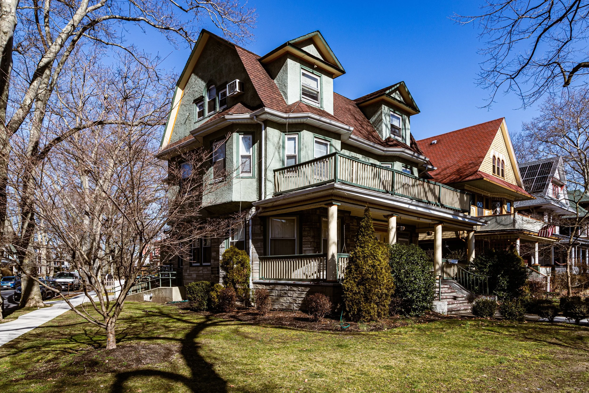
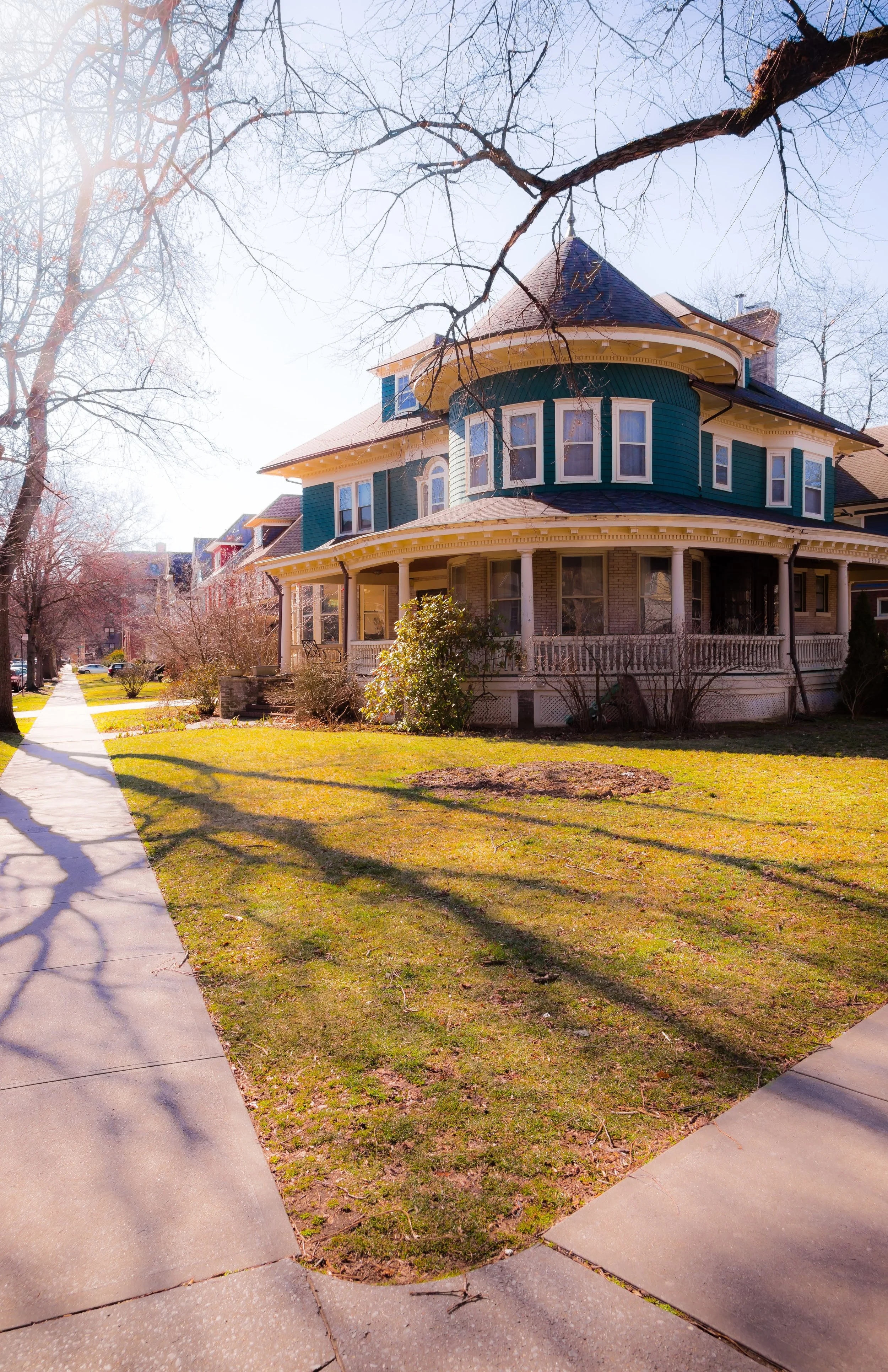
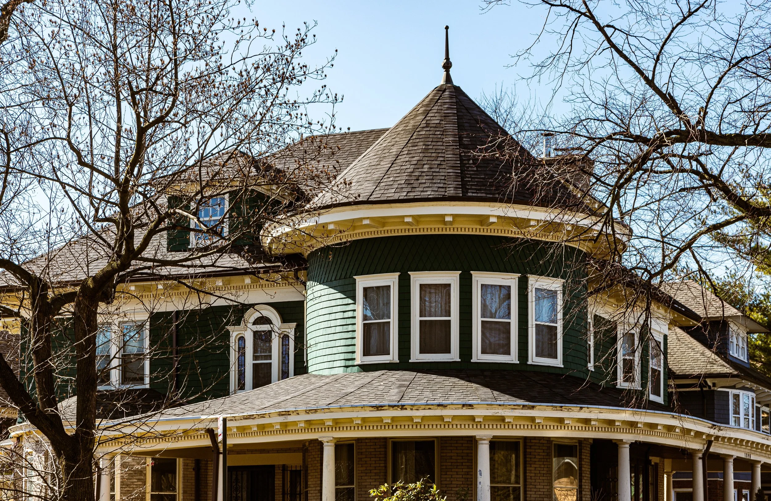
The neighborhood’s built environment is unlike any other in the five boroughs. Streets such as Marlborough Road, Argyle Road, Westminster Road, and East 17th Street are lined with spacious Queen Anne, Colonial Revival, Tudor, and Shingle Style houses—each distinct, yet harmoniously arranged amid mature maples and elms. The business corridor of Cortelyou Road anchors the community’s social life with cafés, markets, and bookstores, while Newkirk Plaza, just to the north, provides transit links to Manhattan. To the east, the tree canopy of Ocean Avenue merges seamlessly with the green expanses of Prospect Park South and Flatbush’s historic parkland, reinforcing the district’s pastoral character within the urban grid.
Etymology and Origins
The name Ditmas Park derives from the Ditmas family, Dutch settlers who farmed this land for more than two centuries. Their holdings—part of the original township of Flatbush, founded in 1652—stretched across fertile meadows and woodlots that remained rural well into the 19th century. The Ditmas homestead once stood near what is now Dorchester Road, surrounded by orchards and fields extending to the Flatbush Plank Road (today’s Flatbush Avenue).
By the late 1800s, as Brooklyn evolved from a patchwork of towns into a unified city, the farmland of Flatbush became a frontier for suburban development. With the completion of Prospect Park (1867–1873) and the expansion of streetcar and rail lines along Coney Island Avenue and Ocean Avenue, developers recognized the potential to create a new kind of neighborhood—one that blended suburban spaciousness with urban accessibility.
The name “Victorian Flatbush” came later, a modern umbrella term for a cluster of residential tracts—including Ditmas Park, Fiske Terrace, Beverley Square, and Albemarle-Kenmore Terraces—all developed between 1899 and 1914 and unified by their late Victorian and Edwardian architecture. Ditmas Park, platted in 1902 by the Ditmas Park Company, became the archetype of this suburban vision.
The Neighborhood
19th Century Origins: The Suburban Dream in Brooklyn
The 1890s–1910s marked Ditmas Park’s defining era of development. Real estate entrepreneurs such as Lewis Pounds and Dean Alvord (the latter also responsible for nearby Prospect Park South) purchased tracts of farmland and laid out broad streets with underground utilities, paved sidewalks, and landscaped medians—features that symbolized modernity and refinement.
The Ditmas Park Company, established in 1902, marketed the area as a “suburban paradise within the city limits.” Advertisements in the Brooklyn Eagle promised “pure air, detached homes, and every urban convenience.” To ensure architectural diversity and exclusivity, the developers imposed covenants dictating minimum lot sizes, setbacks, and building materials. The results were spectacular: more than 200 large freestanding houses in a dazzling array of late Victorian styles.
The architectural variety remains the neighborhood’s hallmark. Queen Anne houses feature asymmetrical towers and wraparound porches; Colonial Revival homes exhibit white columns and wide verandas; Tudor cottages reveal half-timbered façades and leaded-glass windows; and Shingle Style mansions display gambrel roofs and cedar siding. The architects—among them Benjamin Dreisler, John J. Petit, and Slee & Bryson—crafted homes that balanced individuality with cohesive streetscapes.
Early–Mid 20th Century: Prosperity, Stability, and Transition
During the first half of the 20th century, Ditmas Park flourished as a middle- and upper-middle-class residential enclave. Its residents included doctors, lawyers, and educators, many of whom commuted to Manhattan via the nearby BMT Brighton Line (today’s Q train). The district’s spacious homes, tree-lined streets, and proximity to Prospect Park gave it an aura of quiet prosperity.
By the 1930s–1950s, the neighborhood began to diversify. Jewish and Italian families moved in from northern Brooklyn, followed by Caribbean-American professionals and families drawn to Ditmas Park’s beauty and stability. Churches, synagogues, and civic associations reflected the area’s growing pluralism, while Cortelyou Road developed into a commercial corridor serving multiple generations.
The postwar years brought change across Flatbush: suburban flight, urban renewal, and redlining threatened many historic neighborhoods. Ditmas Park, though not immune, retained its architectural integrity and community activism. While some large homes were subdivided into apartments, most remained intact—preserved by residents who valued the neighborhood’s unique charm.
Victorian Flatbush / Ditmas Park Photographic Video
Late 20th Century: Rediscovery and Preservation
By the 1970s, preservationists and longtime homeowners had begun to champion Ditmas Park as an architectural treasure. The district’s early 20th-century houses—many still occupied by their original families—stood in stark contrast to the high-rise developments proliferating elsewhere in Brooklyn. In 1981, the New York City Landmarks Preservation Commission designated the Ditmas Park Historic District, recognizing it as one of the nation’s best-preserved ensembles of suburban Victorian architecture within a major metropolis.
Throughout the 1980s–1990s, a new generation of residents—artists, teachers, and professionals priced out of Park Slope and Windsor Terrace—discovered Ditmas Park’s affordability and tranquility. Community groups such as the Flatbush Development Corporation and Ditmas Park Association organized house tours, tree-planting drives, and preservation campaigns that strengthened local pride. Despite periods of economic stress, the area’s tight-knit community ensured that neglect never overwhelmed its fabric.
21st Century: A Living Landmark of Brooklyn Domestic Life
In the 21st century, Ditmas Park has emerged as one of Brooklyn’s most admired neighborhoods—a living museum of American domestic architecture, yet vibrant and evolving. Its population reflects the borough’s diversity: Caribbean-American families with deep roots, Russian and South Asian immigrants, and newer arrivals seeking both historic beauty and community warmth.
The Cortelyou Road corridor has flourished as a hub of neighborhood life, lined with coffeehouses, organic markets, restaurants, and bookstores. Newkirk Plaza, one of the oldest open-air subway plazas in the United States, remains a daily crossroads where the rhythms of old Flatbush meet the cosmopolitan energy of new Brooklyn. At the same time, rising real estate values have revived debates over preservation versus modernization—a balance the community continues to navigate with care.
The district’s homes, many now restored to their original splendor, stand as tangible testaments to the artistry of a bygone age. Porches host block parties and Halloween displays; lawns bloom with lilacs and hydrangeas; and residents still refer to streets by their historic charm—“The Avenues of Old Flatbush”—with affection and pride.
Victorian Flatbush / Ditmas Park Photographic Video
Spirit and Legacy
The spirit of Ditmas Park lies in its architectural grace and human scale—a neighborhood where the ideals of the early 20th century suburb endure within the modern city. It embodies a rare harmony of craftsmanship, community, and greenery, offering proof that urban life can be both beautiful and humane.
New York City
Use this custom Google map to explore where every neighborhood in all five boroughs of New York City is located.
The Five Boroughs
One of New York City’s unique qualities is its organization in to 5 boroughs: Manhattan, Brooklyn, Queens, The Bronx, and Staten Island. These boroughs are part pragmatic administrative districts, and part vestiges of the region’s past. Each borough is an entire county in New York State - in fact, Brooklyn is, officially, Kings County, while Staten Island is, officially Richmond County. But that’s not the whole story …
Initially, New York City was located on the southern tip of Manhattan (now the Financial District) that was once the Dutch colony of New Amsterdam. Across the East River, another city was rising: Brooklyn. In time, the city planners realized that unification between the rapidly rising cities would create commercial and industrial opportunities - through streamlined administration of the region.
So powerful was the pull of unification between New York and Brooklyn that three more counties were pulled into the unification: The Bronx, Queens, and Staten Island. And on January 1, 1898, the City of New York unified two cities and three counties into one Greater City of New York - containing the five boroughs we know today.
But because each borough developed differently and distinctly until unification, their neighborhoods likewise uniquely developed. Today, there are nearly 390 neighborhoods, each with their own histories, cultures, cuisines, and personalities - and each with residents who are fiercely proud of their corner of The Big Apple.


