NORTHSIDE WILLIAMSBURG
Brooklyn
Geographic Setting
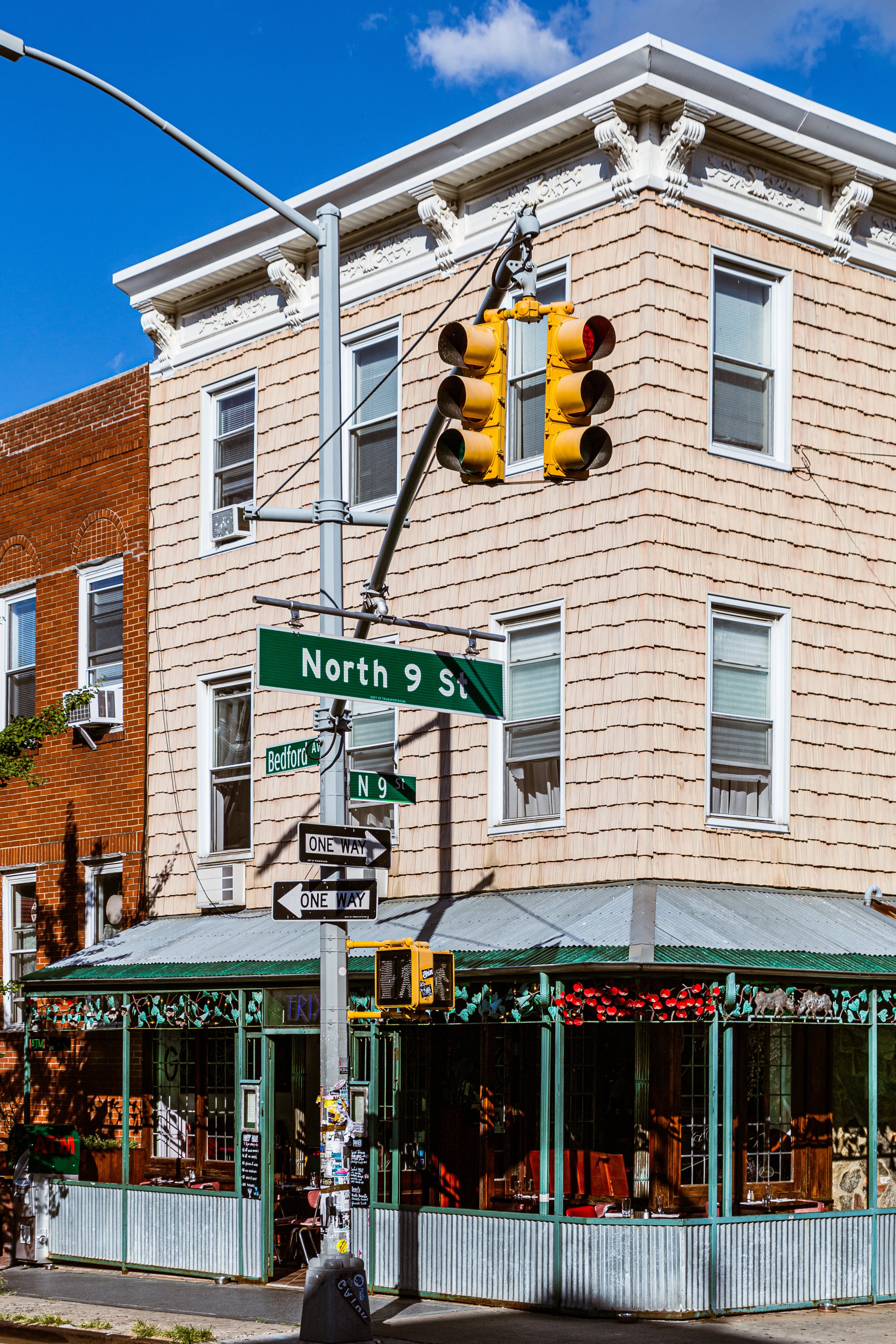
Stretching from the Grand Street north to McCarren Park and N 15th Street, and from the East River waterfront east to roughly Union Avenue, Northside Williamsburg occupies the industrial-to-artistic corridor that came to define Brooklyn’s cultural rebirth at the turn of the 21st century. Long before it became synonymous with creative reinvention, it was one of the city’s most important manufacturing centers, its warehouses, sugar refineries, and shipyards supplying the metropolis across the river. The neighborhood’s grid — narrow streets like North 6th, North 8th, and Berry — still bears the imprint of those industrious origins, even as cafés, galleries, and condominiums now line its cobblestones.
Etymology and Origins
The term Northside distinguishes this part of Williamsburg from the Southside (Los Sures), which lies below Grand Street. Both names date to the mid-19th century, when the independent City of Williamsburg was divided into wards. The Northside, settled earlier and more heavily industrialized, developed a character distinct from its southern counterpart — more German and Polish than Puerto Rican, more factories than rowhouses.
The name Williamsburg itself derives from Jonathan Williams, a U.S. Army engineer and grandnephew of Benjamin Franklin, who surveyed and developed the area in the early 1800s. The waterfront location, directly across from Manhattan’s East Village, made it ideal for shipbuilding and trade. In 1855, Williamsburg was annexed to the City of Brooklyn, and by the Civil War it was one of the nation’s busiest industrial districts.
The Neighborhood
19th Century: Industrial Powerhouse
By the mid-1800s, the Northside was dense with factories: sugar refineries, ropeworks, glass plants, and breweries. Chief among them was the Havemeyer & Elder Sugar Refinery, later known as the Domino Sugar Plant, whose towering brick complex dominated the waterfront for over a century. Immigrants from Germany, Poland, and Ireland filled the neighborhood’s tenements, working long hours in the hot, loud factories that gave Williamsburg its gritty prosperity.
The streets were alive with commerce — horse-drawn carts, dockworkers, and shopkeepers speaking a dozen languages. Churches rose to serve the faithful: St. Vincent de Paul, St. Cecilia’s, and the Holy Ghost Roman Catholic Church reflected the neighborhood’s European Catholic core. Schools, beer gardens, and social halls completed the fabric of a working-class, self-contained city.
By 1898, when Brooklyn joined the consolidated City of New York, the Northside had achieved both industrial maturity and residential density. Its waterfront wharves extended deep into the river, loading barges bound for Manhattan, while inland streets hummed with foundries and tenement life.
Early 20th Century: The Urban Village
The early 1900s were a period of continuity and overcrowding. New immigrant waves — Italian, Jewish, and later Eastern European — joined the established German and Irish communities. Small factories produced everything from iron fittings to pianos, while modest brick and brownstone walkups filled every available lot.
The Northside’s identity as a hardworking industrial village persisted through the 1930s and 1940s. The Williamsburg Bridge Plaza, completed in 1903, provided new links to Manhattan, while the IND Crosstown Line (G train) and L train connected the district to the rest of Brooklyn. During World War II, the shipyards and factories worked around the clock, producing supplies and materials for the war effort.
Mid-20th Century: Decline and Exodus
After the war, industry began to leave the waterfront. Container shipping shifted to New Jersey, and factories closed through the 1950s and 1960s. Many middle-class families moved to Queens or Long Island, leaving behind vacant warehouses and aging housing stock.
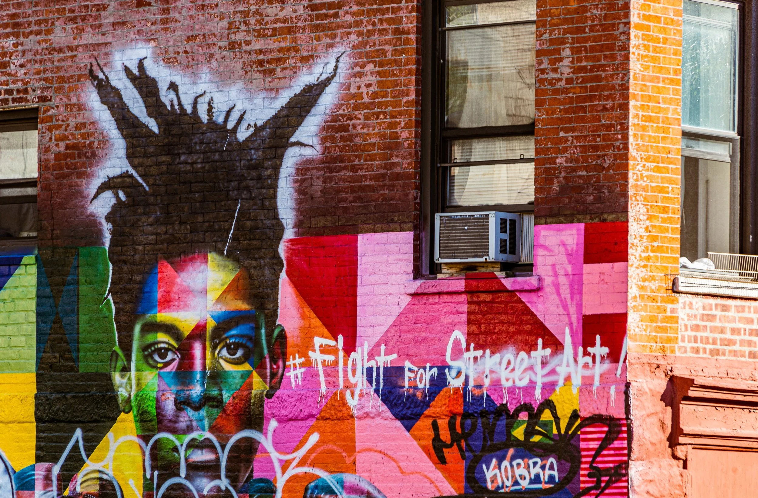
In the 1970s, parts of Northside Williamsburg fell into neglect. Fires, disinvestment, and crime took their toll. Yet the area’s low rents and large industrial lofts soon attracted a new population: artists, musicians, and filmmakers seeking cheap studio space. The very buildings once filled with factory workers now echoed with the sounds of rehearsals, welding torches, and typewriters.
Northside Williamsburg Video Coming Soon
Late 20th Century: The Creative Frontier
By the 1980s, the Northside had become Brooklyn’s bohemian frontier. Abandoned factories along Kent Avenue and Wythe Avenue were converted into live-work lofts and art collectives. DIY galleries such as Minor Injury and Sideshow Gallery flourished, while small performance spaces and underground music venues gave rise to an avant-garde culture that rivaled Manhattan’s East Village scene.
The 1990s brought cafes, record stores, and experimental theater. Artists from across the world moved into cheap apartments, and Williamsburg’s Northside became synonymous with creativity and defiance — a community of makers living amid industrial decay.
21st Century: Reinvention and Reckoning
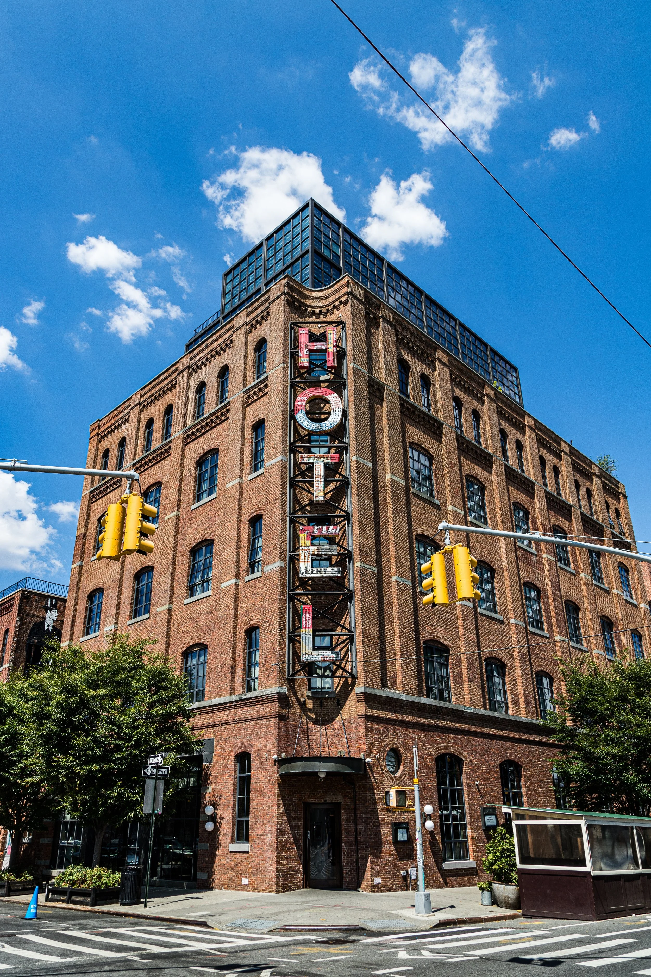
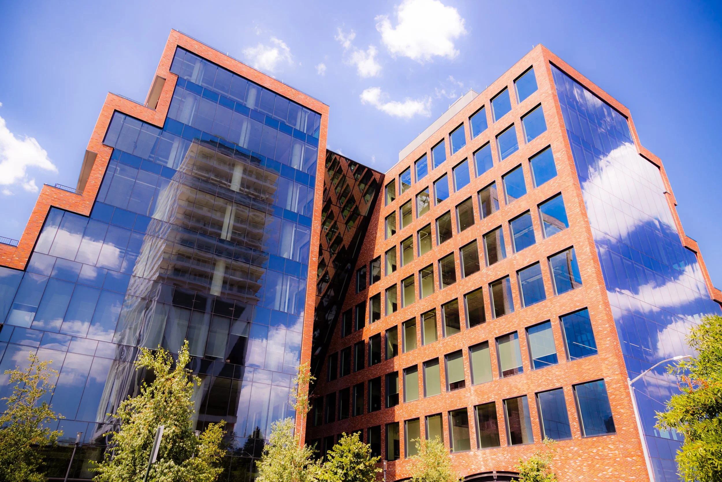
The rezoning of the Williamsburg waterfront in 2005 transformed the Northside permanently. Former factories gave way to glass towers and landscaped parks, notably Bushwick Inlet Park and North 5th Street Pier. The Domino Sugar Refinery redevelopment turned the iconic plant into mixed-use space, symbolizing both renewal and loss.
As property values soared, many long-time residents and artists were priced out, replaced by professionals and families drawn to the area’s new luxury buildings, proximity to Manhattan, and lively culture. Despite gentrification’s displacement, the Northside retained vestiges of its creative spirit: street murals, community gardens, and converted industrial spaces that still host art studios and galleries.
Today, the neighborhood’s population is diverse but transformed — Polish, Italian, and Hasidic enclaves coexist with younger arrivals from across the country and globe. Boutique hotels, rooftop bars, and concert halls like Brooklyn Bowl and Music Hall of Williamsburg draw crowds nightly, while the Smorgasburg food market and Brooklyn Flea echo the entrepreneurial energy that once defined the area’s industrial past.
Northside Williamsburg Photo Gallery
Architecture and Atmosphere
Architecturally, the Northside is an archive of industrial grandeur and modern ambition. 19th-century brick warehouses with cast-iron lintels stand beside sleek condominiums of glass and steel. The Domino Sugar Refinery’s smokestack remains a totem of the old city, while cobblestone streets, faded ghost signs, and restored lofts preserve the patina of history.
The atmosphere shifts block by block: waterfront promenades alive with cyclists and joggers give way to quiet side streets where three-story tenements and century-old churches endure. The juxtaposition of old labor and new luxury defines the neighborhood’s present tension — a place where reinvention has not yet erased remembrance.
Spirit and Legacy
Northside Williamsburg’s legacy is one of continual transformation: from farmland to factory, from factory to frontier, from frontier to phenomenon. It is a neighborhood that has repeatedly redefined what Brooklyn means — industrious, creative, self-made.
New York City
Use this custom Google map to explore where every neighborhood in all five boroughs of New York City is located.
The Five Boroughs
One of New York City’s unique qualities is its organization in to 5 boroughs: Manhattan, Brooklyn, Queens, The Bronx, and Staten Island. These boroughs are part pragmatic administrative districts, and part vestiges of the region’s past. Each borough is an entire county in New York State - in fact, Brooklyn is, officially, Kings County, while Staten Island is, officially Richmond County. But that’s not the whole story …
Initially, New York City was located on the southern tip of Manhattan (now the Financial District) that was once the Dutch colony of New Amsterdam. Across the East River, another city was rising: Brooklyn. In time, the city planners realized that unification between the rapidly rising cities would create commercial and industrial opportunities - through streamlined administration of the region.
So powerful was the pull of unification between New York and Brooklyn that three more counties were pulled into the unification: The Bronx, Queens, and Staten Island. And on January 1, 1898, the City of New York unified two cities and three counties into one Greater City of New York - containing the five boroughs we know today.
But because each borough developed differently and distinctly until unification, their neighborhoods likewise uniquely developed. Today, there are nearly 390 neighborhoods, each with their own histories, cultures, cuisines, and personalities - and each with residents who are fiercely proud of their corner of The Big Apple.


