FIELDSTON
The Bronx
Geographic Setting
Bounded by Riverdale Avenue to the southwest, the Henry Hudson Parkway to the west and north, Broadway to the east, and West 238th and West 240th Streets to the south, Fieldston occupies a lofty, secluded enclave on the western heights of the Bronx. Nestled between the grand boulevards of Riverdale and the bustle of Kingsbridge, Fieldston rises on a series of rolling ridges overlooking the Hudson River Valley to the west and the Harlem River basin to the east. Its topography—steep, wooded, and irregular—dictated the curvilinear pattern of streets such as Fieldston Road, West 246th Street, and Manhattan College Parkway, forming a rare oasis of suburban calm within New York City.
Unlike the gridded neighborhoods surrounding it, Fieldston’s landscape feels almost rural: shaded lanes wind past stately homes set amid gardens and trees, with stone walls, wrought-iron gates, and period streetlamps reinforcing its early-20th-century character. The neighborhood’s boundaries are marked as clearly by sensation as by geography—the quiet rustle of leaves replaces the hum of city traffic as one ascends the hill from Broadway, signaling entry into one of the Bronx’s most distinctive residential districts.
Etymology
The name “Fieldston” derives from the estate of Major Joseph Delafield (1790–1875), a prominent lawyer, surveyor, and War of 1812 veteran whose family once owned hundreds of acres stretching from the Hudson River to Broadway. Delafield named his estate “Fieldston” after the family’s ancestral home in Yorkshire, England. When his descendants began subdividing the land in the early 20th century, they retained the name to evoke both heritage and pastoral grace—a “town within the fields.”
Thus, “Fieldston” signifies not only lineage but vision: the fusion of old-world gentility with new-world city planning, an experiment in suburban living that would remain within the urban bounds of New York.
The Neighborhood
Origins through the 19th Century
Before development, the Fieldston tract formed part of the Delafield family estate, established in 1829 when Joseph Delafield purchased land from the Van Cortlandt family, whose colonial manor once spanned much of today’s northwestern Bronx. The Delafields built a mansion overlooking the Hudson River and farmed the surrounding slopes, maintaining orchards and pastureland while carefully preserving the site’s natural contours.
For most of the 19th century, this remained private countryside. The area’s proximity to Van Cortlandt Park and the Spuyten Duyvil Creek made it a favored destination for weekend excursions, but urbanization stayed distant. The construction of the New York Central Railroad’s Hudson Line (1850s) and later the Broadway streetcar (1880s) improved accessibility, yet the Delafields resisted subdivision until after the turn of the century, determined to shape development according to their own aesthetic and moral ideals rather than speculative demand.
Early 20th Century: The Garden Suburb Realized
In 1909, the Delafield Estate Company—founded by Joseph’s sons—initiated the planned development of Fieldston as an exclusive, architecturally controlled residential community. They hired civil engineer Albert E. Wheeler and landscape architect Frederick Law Olmsted Jr. (son of Central Park’s designer) to design a neighborhood that harmonized with the terrain. Rejecting the city’s rigid street grid, Olmsted’s plan followed the natural topography, with curved roads, generous lots, and landscaped setbacks that preserved trees and sightlines.
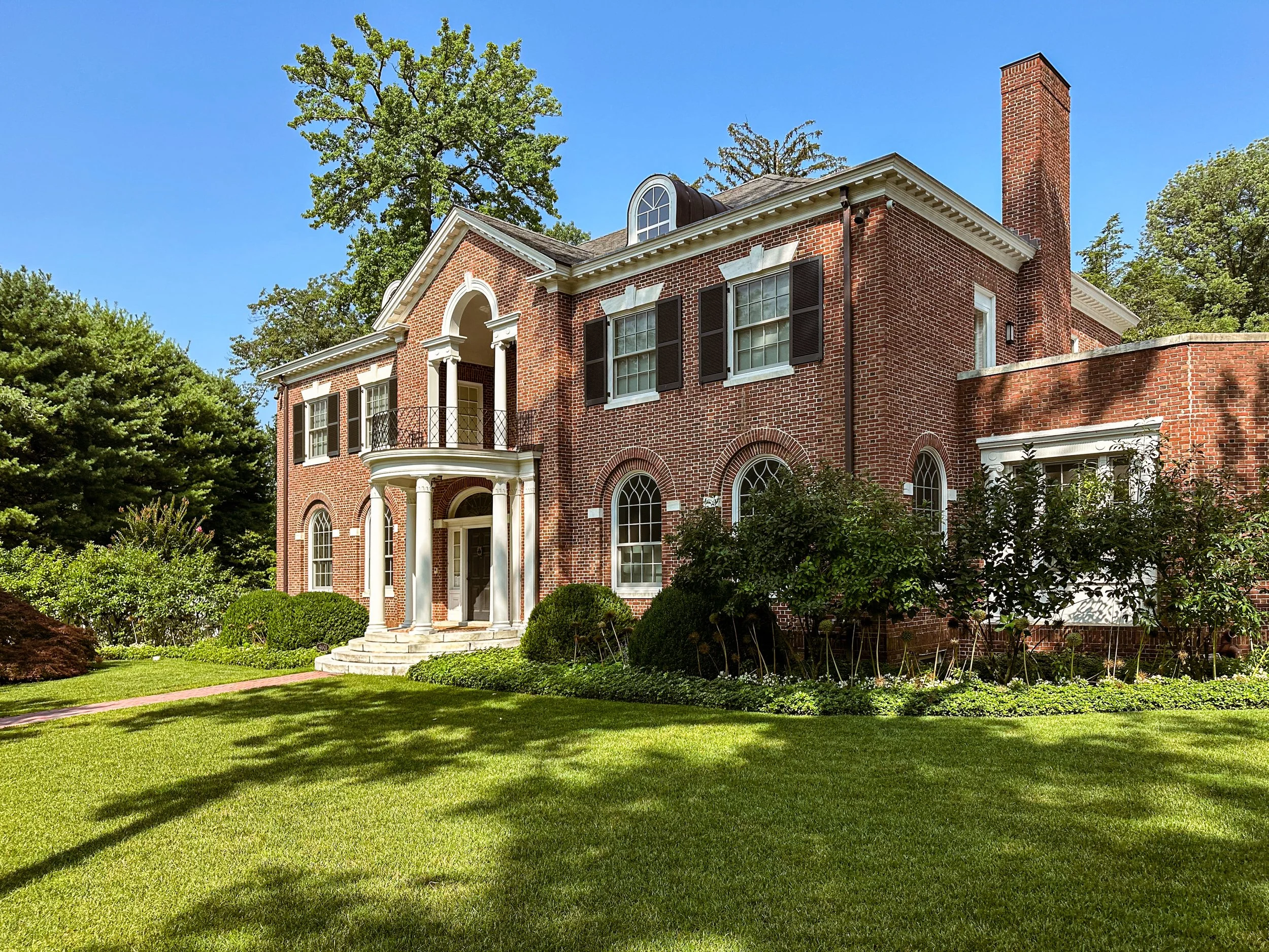
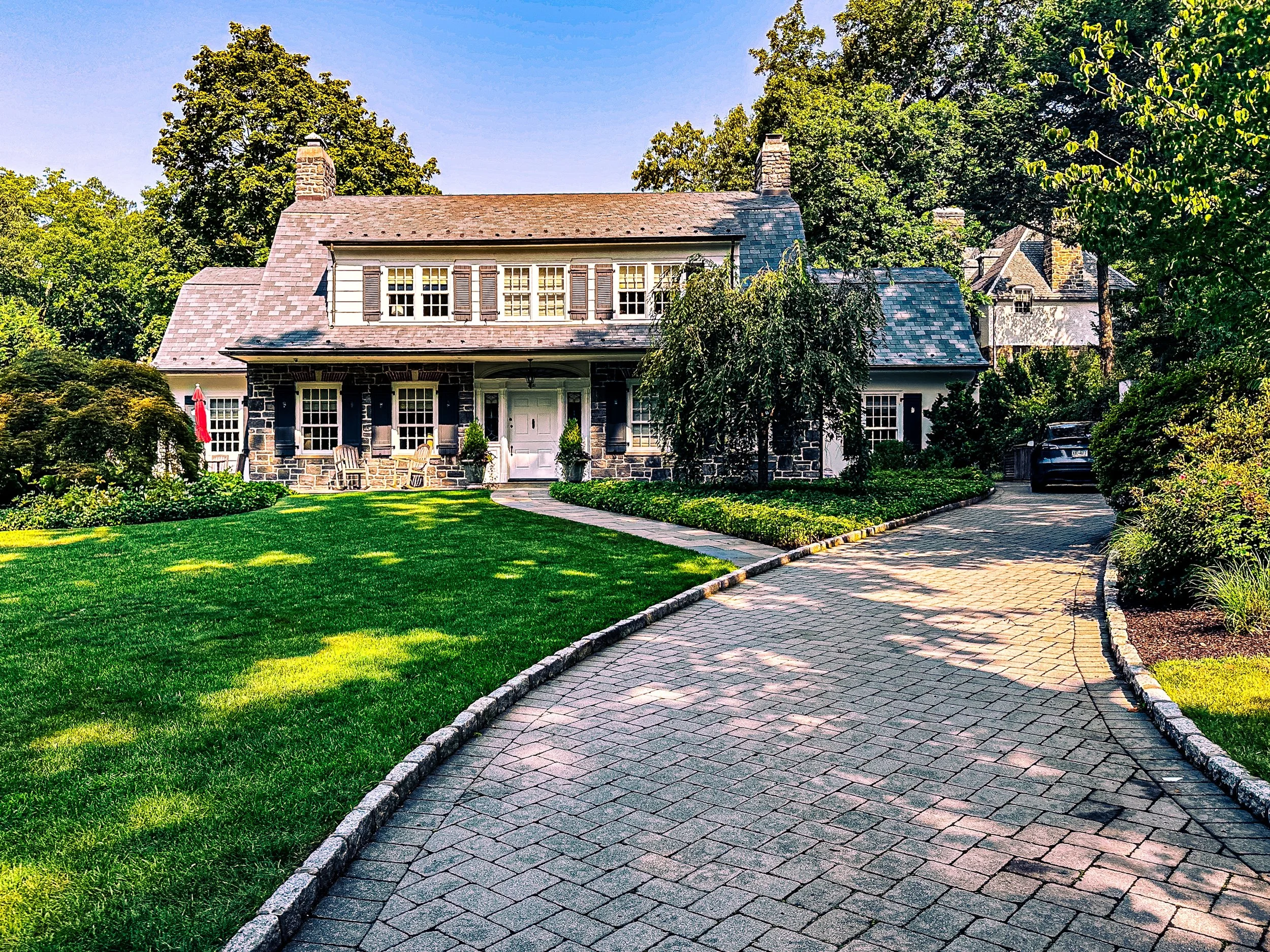
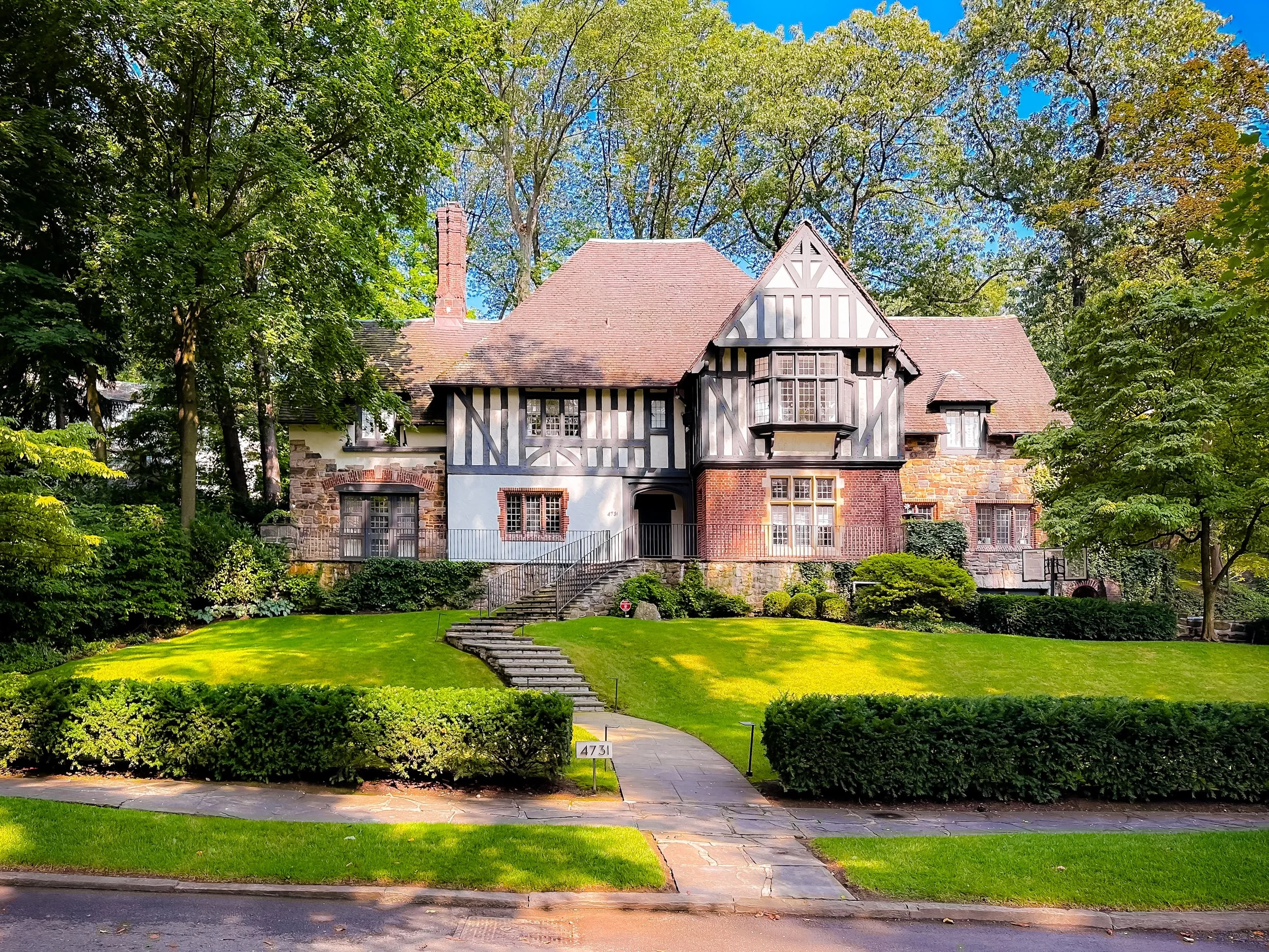
Construction began around 1910, producing large detached homes in Tudor Revival, Georgian, Colonial, and Arts and Crafts styles, many designed by leading architects such as Dwight James Baum, Delano & Aldrich, and Van Vleck & Goldsmith. Fieldston was formally incorporated as a private community in 1928, maintaining its own streets, streetlights, and security patrols—a status it retains to this day.
Early residents were professionals, academics, and artists—drawn by the promise of suburban living within city limits. The neighborhood’s proximity to Manhattan College and elite schools such as Horace Mann, Riverdale Country School, and Ethical Culture Fieldston School (est. 1928) reinforced its identity as a cultivated, intellectual enclave. The community’s winding roads and absence of commercial activity preserved the illusion of rural seclusion even as the rest of the Bronx urbanized.
Fieldston Video Coming Soon
Mid–Late 20th Century: Preservation and Adaptation
Fieldston weathered the mid-century transformations that reshaped much of the Bronx with remarkable stability. While other districts saw waves of construction and demographic turnover, Fieldston remained largely as built, its large single-family homes passing from one generation to the next. The Henry Hudson Parkway, completed in 1937, formed a physical and psychological boundary between Fieldston and the denser neighborhoods to the west, protecting its tranquility but also isolating it from urban energy.
During the 1950s–1970s, as the Bronx grappled with depopulation and disinvestment, Fieldston remained a bastion of middle- and upper-middle-class continuity. Community associations and the Fieldston Property Owners’ Association maintained strict oversight of zoning and upkeep. In 2006, the New York City Landmarks Preservation Commission designated Fieldston a Historic District, recognizing its exceptional coherence as one of America’s most intact examples of early suburban planning.
Despite its exclusivity, Fieldston was not immune to the social currents of its time. The postwar decades saw gradual diversification, particularly among faculty and professionals affiliated with nearby colleges and schools. The presence of the Ethical Culture Fieldston School, known for progressive education, gave the neighborhood a cultural identity distinct from mere affluence—rooted in liberal humanism and civic responsibility.
21st Century: Heritage, Sustainability, and Quiet Renewal
Today, Fieldston remains one of the Bronx’s most distinctive enclaves: a private, landmarked residential district where city and suburb merge seamlessly. The tree canopy planted a century ago has matured into a dense green vault, shading narrow lanes where historic homes stand in near-original condition. Property owners maintain their residences under strict architectural guidelines, ensuring that any renovation honors the neighborhood’s original design principles.
Environmental consciousness has deepened Fieldston’s long-standing commitment to landscape preservation. Many homes now incorporate solar panels, green roofs, and stormwater management systems that respect the area’s fragile topography. The community participates in Bronx-wide conservation efforts through collaborations with Van Cortlandt Park Alliance and Riverdale Nature Preservancy, reinforcing its role as both steward and neighbor within the broader environmental network of the Bronx’s northwest corridor.
Despite its privacy, Fieldston engages with the surrounding borough through its educational institutions, historic preservation programs, and cultural outreach from the Ethical Culture Fieldston School, whose campus anchors the neighborhood’s civic heart.
Fieldston Photo Gallery
Spirit and Legacy
The spirit of Fieldston endures in its deliberate harmony between architecture and nature—a vision conceived over a century ago and sustained through vigilance and pride. It represents a rare success story in New York’s urban history: a planned community that has retained both its physical form and philosophical intent.
New York City
Use this custom Google map to explore where every neighborhood in all five boroughs of New York City is located.
The Five Boroughs
One of New York City’s unique qualities is its organization in to 5 boroughs: Manhattan, Brooklyn, Queens, The Bronx, and Staten Island. These boroughs are part pragmatic administrative districts, and part vestiges of the region’s past. Each borough is an entire county in New York State - in fact, Brooklyn is, officially, Kings County, while Staten Island is, officially Richmond County. But that’s not the whole story …
Initially, New York City was located on the southern tip of Manhattan (now the Financial District) that was once the Dutch colony of New Amsterdam. Across the East River, another city was rising: Brooklyn. In time, the city planners realized that unification between the rapidly rising cities would create commercial and industrial opportunities - through streamlined administration of the region.
So powerful was the pull of unification between New York and Brooklyn that three more counties were pulled into the unification: The Bronx, Queens, and Staten Island. And on January 1, 1898, the City of New York unified two cities and three counties into one Greater City of New York - containing the five boroughs we know today.
But because each borough developed differently and distinctly until unification, their neighborhoods likewise uniquely developed. Today, there are nearly 390 neighborhoods, each with their own histories, cultures, cuisines, and personalities - and each with residents who are fiercely proud of their corner of The Big Apple.


