HIGHBRIDGE
The Bronx
Geographic Setting
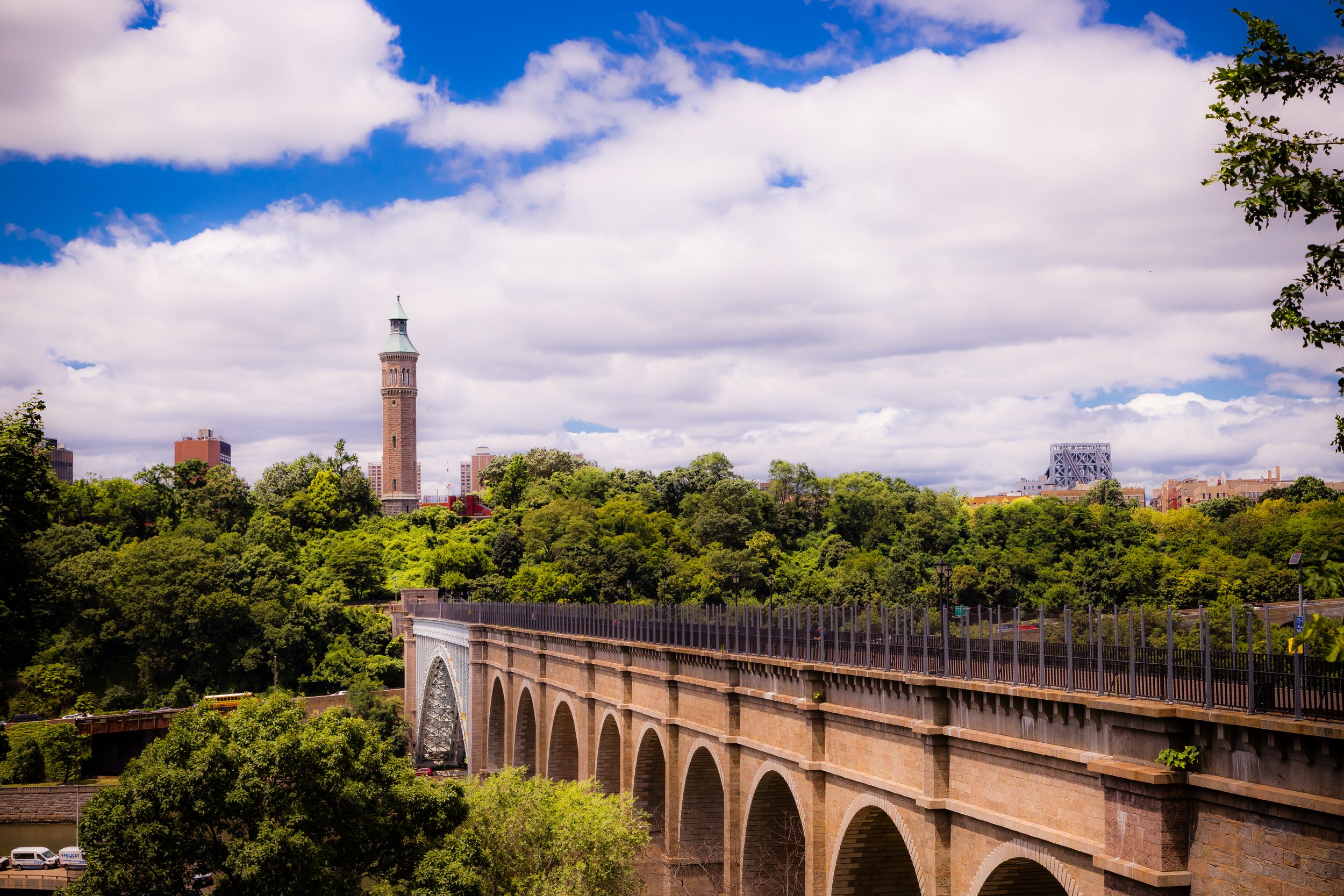
Bounded by the Washington Bridge to the north, Edward L. Grant Highway to the northeast, Jerome Avenue curving along its eastern and southern borders, and the Harlem River to the west, Highbridge occupies one of the Bronx’s most historic and topographically dramatic settings. Rising sharply from the riverbanks opposite Upper Manhattan, the neighborhood is defined by its steep hills, winding streets, and commanding views across the High Bridge—the city’s oldest surviving bridge and the structure from which the community takes its name.
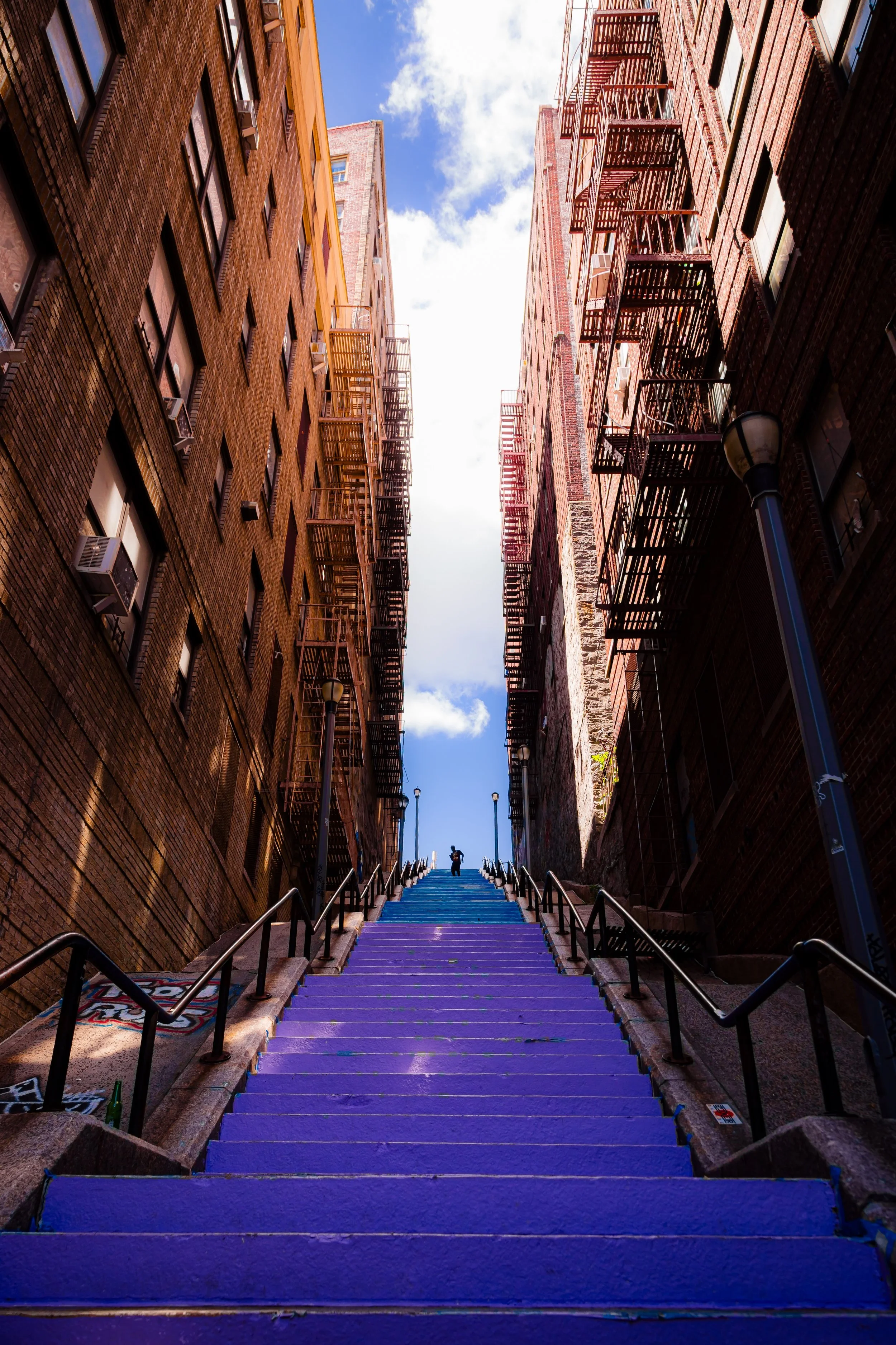
The terrain, part of the ancient Fordham gneiss ridge, shapes both the street pattern and the experience of the neighborhood. Streets such as Anderson Avenue, Ogden Avenue, and University Avenue climb sharply from the river’s edge to the hilltop, while 167th, 168th, and 170th Streets trace east–west routes through densely packed blocks of five- and six-story apartment buildings. Along Jerome Avenue, the elevated 4 train provides a visual and auditory spine, its rhythmic clatter a constant reminder of urban life. Yet despite this density, the neighborhood retains open vistas and pockets of greenery—most notably Highbridge Park and the Mullaly Park recreational fields near the Grand Concourse. From its river overlooks, one can see the elegant arches of the High Bridge Aqueduct, the spire of the Highbridge Water Tower, and the shimmering span of the Washington Bridge, which together root the neighborhood in its 19th-century origins.
Etymology
The name “Highbridge” derives directly from the High Bridge, the iconic stone aqueduct that once carried the Croton Aqueduct over the Harlem River. Completed in 1848, the bridge connected Manhattan and the Bronx, its 140-foot-high masonry arches symbolizing the triumph of urban engineering and the expansion of New York’s water system. As settlement grew around its Bronx terminus, the surrounding district came to be known simply as “High Bridge.”
The term thus connotes both geography and ingenuity: “high” for its elevation above the river gorge, and “bridge” for the vital conduit linking boroughs and bringing life-giving water to the city. Over time, “Highbridge” (as a single word) became the accepted local usage—synonymous with both the structure and the neighborhood it inspired.
The Neighborhood
Origins through the 19th Century
Long before the aqueduct transformed the landscape, the land that became Highbridge was part of the Morris family estate, descendants of Lewis Morris, signer of the Declaration of Independence and proprietor of Morrisania. In the 18th and early 19th centuries, the area remained rural, characterized by wooded hills and small farms overlooking the Harlem River. Its isolation—then accessible only by ferry or rough country roads—preserved it from early urbanization.
The decisive moment came with the construction of the Croton Aqueduct (1837–1848), a monumental public works project designed to bring fresh water from Westchester to a rapidly growing Manhattan. The High Bridge, spanning the Harlem River between 170th Street in Manhattan and the Bronx hillside, was the aqueduct’s crowning feature. Its completion not only changed the skyline but also attracted engineers, workers, and settlers to the surrounding area.
By the 1860s–1870s, the region north of the bridge developed as a small suburban village—complete with country inns, villas, and picnic grounds that drew weekend visitors from Manhattan. The opening of the Washington Bridge (1888) and the Jerome Avenue trolley line further integrated Highbridge into the expanding metropolis. Early housing, primarily freestanding wood and brick homes, lined curving streets that followed the contours of the hills.
Early 20th Century: From Suburb to City
The turn of the 20th century brought sweeping transformation. With the annexation of the western Bronx into New York City in 1874 and the extension of rapid transit northward, Highbridge shifted from semi-rural suburb to urban neighborhood. The IRT Jerome Avenue Line (4 train) opened in 1917, connecting the district directly to Manhattan and spurring a wave of residential construction.
Between 1910 and 1930, developers erected rows of five- and six-story apartment buildings in Renaissance Revival and Art Deco styles, replacing older houses and filling the hillsides with solid masonry structures designed for working- and middle-class tenants. Anderson Avenue and Ogden Avenue became lined with ornate facades, cornices, and courtyard entrances that still characterize the neighborhood’s architectural rhythm today.
Highbridge’s population during this period was largely Irish, Jewish, and Italian, with a significant number of Eastern European immigrants. Churches such as Sacred Heart (founded 1875) and community institutions anchored social life, while small businesses flourished along Jerome Avenue and 167th Street. The nearby Yankee Stadium (opened 1923) at the southern edge of the neighborhood added both pride and commotion, bringing crowds and commerce that reverberated through the local streets.
Highbridge Video Coming Soon
Mid–Late 20th Century: Decline, Struggle, and Survival
By the 1950s, demographic shifts began reshaping Highbridge. As white ethnic residents moved to the suburbs, new arrivals—Puerto Rican, African-American, and later Dominican families—brought new languages, faiths, and cultural traditions. Urban renewal projects, highway construction, and disinvestment across the South Bronx destabilized nearby areas, and Highbridge, while less devastated than others, suffered from neglect.
The 1970s fiscal crisis hit hard. Arson, abandonment, and poverty scarred the neighborhood, and the once-proud apartment buildings fell into disrepair. Yet even amid these hardships, Highbridge’s community spirit endured. Churches, tenant associations, and block groups rallied to maintain stability. Organizations such as the Highbridge Community Life Center (founded 1980) began offering education, housing, and social services that became models for grassroots recovery.
By the 1980s–1990s, rehabilitation programs and nonprofit developers had begun restoring housing stock, aided by city and state initiatives. The neighborhood’s resilience was symbolized by the reopening of parks and the steady return of new immigrant families who brought vitality and entrepreneurship to Jerome Avenue’s storefronts.
21st Century: Renewal and Reconnection
In the 21st century, Highbridge has experienced a notable revival while retaining its working-class identity. The High Bridge, closed for over 40 years, was restored and reopened to pedestrians and cyclists in 2015, reconnecting the Bronx and Manhattan as a shared civic space. The bridge’s elegant arches, visible from every vantage in the neighborhood, once again serve as a symbol of connection and pride.
Ongoing investment has improved local schools, housing, and parks. Mullaly Park, Highbridge Park, and the Harlem River Greenway offer new recreational access, while renovated apartment buildings and new affordable housing developments have strengthened the residential core. The population today is among the most diverse in the Bronx, reflecting Dominican, Mexican, African, and Caribbean heritages, alongside long-term residents whose families have been here for generations.
Community institutions—the Highbridge Community Development Corporation, Sacred Heart Church, and neighborhood youth centers—continue to anchor social life. While economic challenges persist, the neighborhood’s physical and social renewal reflects a broader Bronx resurgence grounded in equity and place-based investment.
Highbridge Photo Gallery
Spirit and Legacy
The spirit of Highbridge is inseparable from its geography—an identity built on height, connection, and perseverance. Its towering arches and steep streets embody both the labor that built the modern city and the endurance of those who have kept it alive through hardship and renewal.
New York City
Use this custom Google map to explore where every neighborhood in all five boroughs of New York City is located.
The Five Boroughs
One of New York City’s unique qualities is its organization in to 5 boroughs: Manhattan, Brooklyn, Queens, The Bronx, and Staten Island. These boroughs are part pragmatic administrative districts, and part vestiges of the region’s past. Each borough is an entire county in New York State - in fact, Brooklyn is, officially, Kings County, while Staten Island is, officially Richmond County. But that’s not the whole story …
Initially, New York City was located on the southern tip of Manhattan (now the Financial District) that was once the Dutch colony of New Amsterdam. Across the East River, another city was rising: Brooklyn. In time, the city planners realized that unification between the rapidly rising cities would create commercial and industrial opportunities - through streamlined administration of the region.
So powerful was the pull of unification between New York and Brooklyn that three more counties were pulled into the unification: The Bronx, Queens, and Staten Island. And on January 1, 1898, the City of New York unified two cities and three counties into one Greater City of New York - containing the five boroughs we know today.
But because each borough developed differently and distinctly until unification, their neighborhoods likewise uniquely developed. Today, there are nearly 390 neighborhoods, each with their own histories, cultures, cuisines, and personalities - and each with residents who are fiercely proud of their corner of The Big Apple.


