WHITESTONE
Queens
Geographic Setting
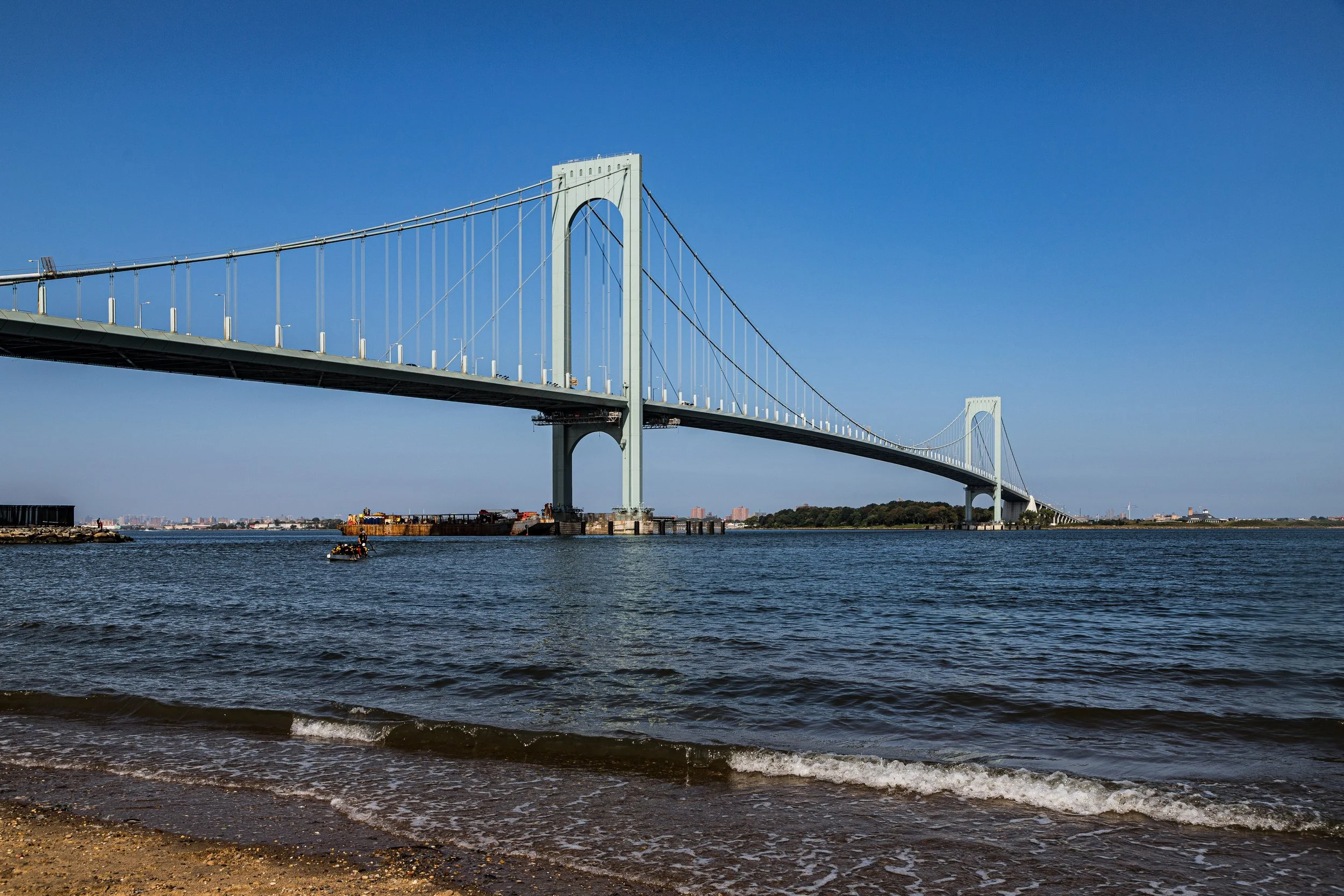
Bounded by 25th Avenue to the south, the Whitestone Expressway (I-678) to the west, the East River to the north, and an eastern border that runs south along 154th Street to the Cross Island Parkway, then east to Utopia Parkway and south again to 25th Avenue, Whitestone occupies the far north-central tip of Queens—a tranquil, waterfront community overlooking the Bronx-Whitestone Bridge and the wide expanse of the river leading into the Long Island Sound.
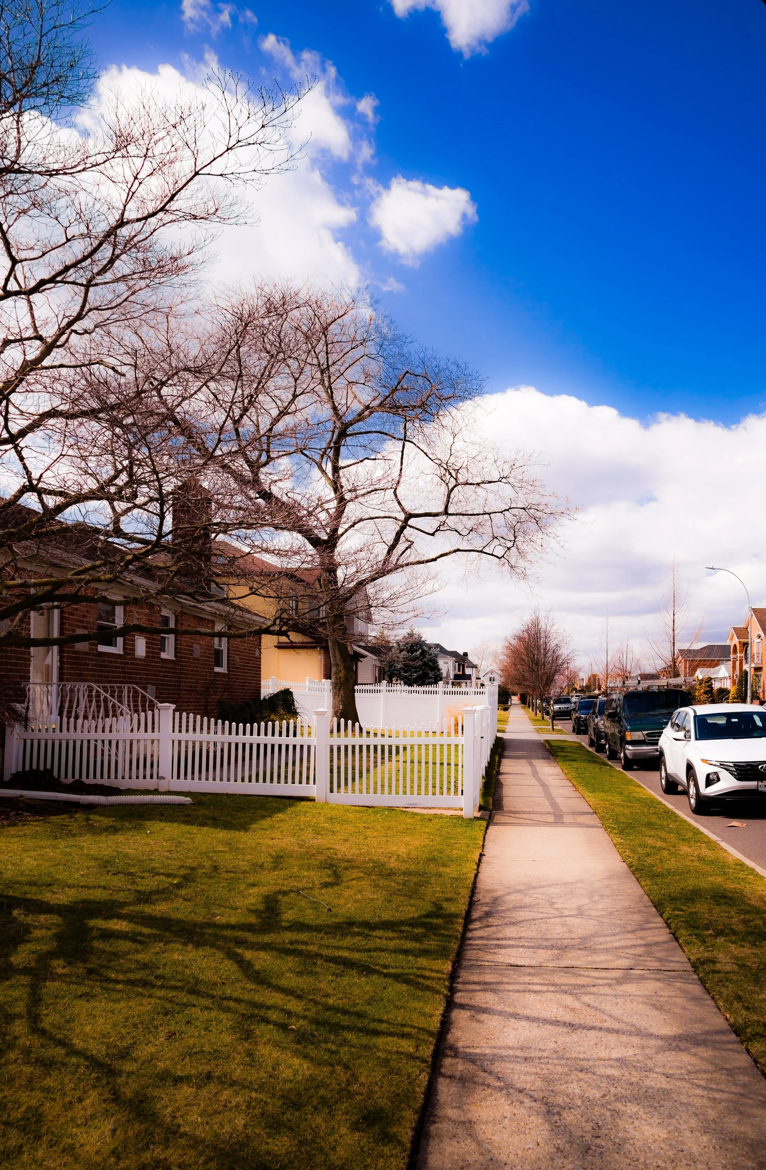
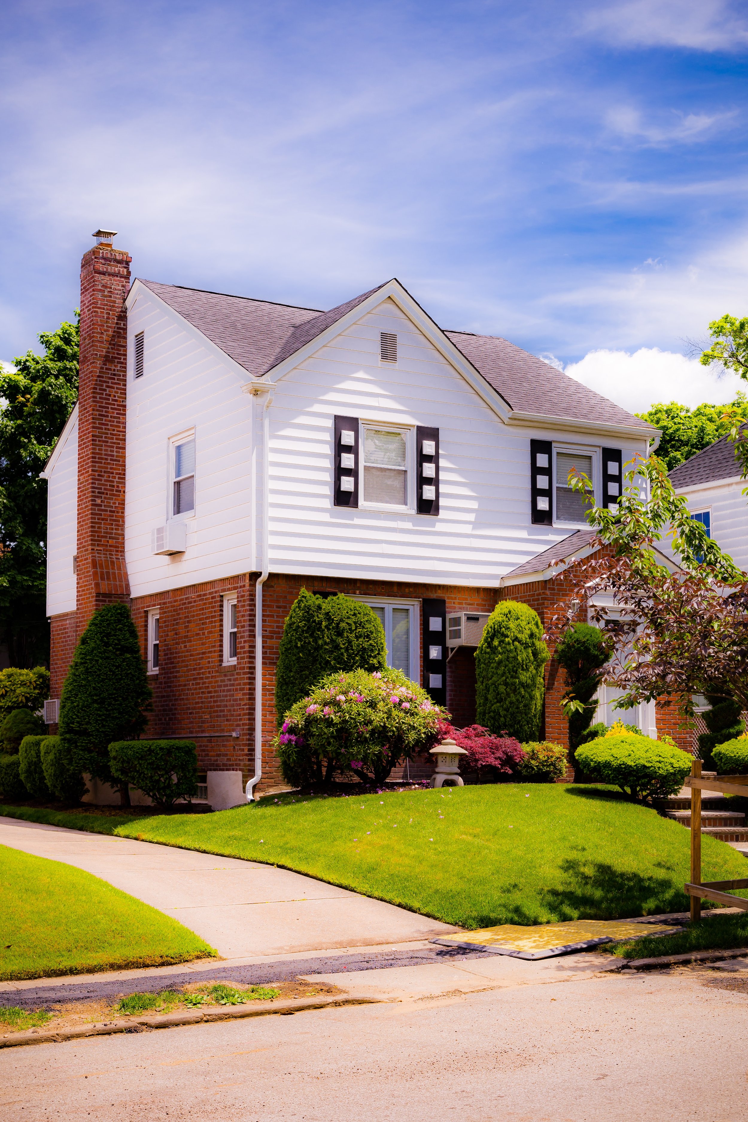
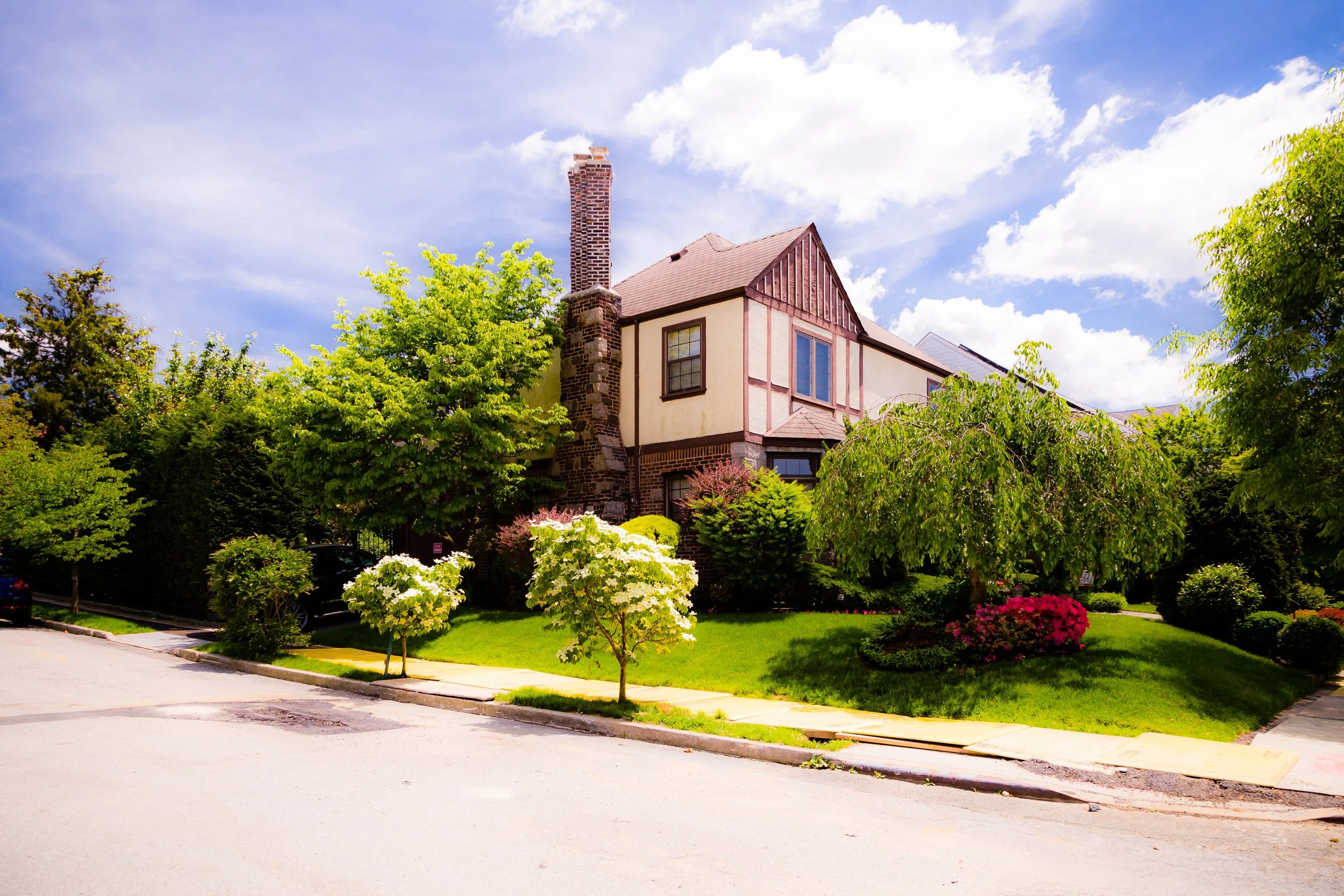
The neighborhood is defined by its sweeping coastal vistas, tree-lined residential streets, and spacious single-family homes, many set on manicured lawns or quiet cul-de-sacs. Its character combines suburban comfort with maritime proximity: docks, yacht clubs, and waterfront parks meet tidy grids of Tudors, Colonials, and Cape Cod houses built through much of the 20th century. Francis Lewis Boulevard, 150th Street, and Whitestone Expressway form the main north-south routes, while 14th Avenue, 20th Avenue, and 25th Avenue connect east-west through low-rise commercial centers.
To the north lies the East River shoreline, edged by Francis Lewis Park, Powell’s Cove, and Malba Bay, offering some of the most scenic views in Queens—particularly at sunset, when the Whitestone Bridge gleams against the skyline.
Etymology and Origins
The name “Whitestone” dates back to the 17th century and derives from a prominent white limestone boulder—once visible along the shoreline—that served as a landmark for Dutch and English settlers navigating the Long Island Sound. Early records refer to the area as “White Stone Point,” a descriptive toponym that endured as farms, wharves, and estates developed along the riverfront.
Originally part of the Town of Flushing, Whitestone’s history reflects the evolution of Queens from agrarian settlement to suburban borough. The area’s fertile soil and river access made it ideal for farming and shipping; by the early 1800s, it supported orchards, fisheries, and small shipyards. Wealthy merchants and ship captains from Manhattan built summer estates here, drawn by the sea breezes and isolation. Among the earliest was Francis Lewis, a signer of the Declaration of Independence, whose estate near today’s Francis Lewis Park gave its name to the main boulevard.
The opening of the Whitestone Branch of the Long Island Rail Road in 1869 connected the rural hamlet to the rest of the city, spurring gradual suburban development. By the early 20th century, Whitestone had evolved into a quiet commuter suburb, prized for its waterfront location and village-like character.
The Neighborhood
Early–Mid 20th Century: Suburban Expansion and the Bridge Era
The defining transformation of Whitestone came with the completion of the Bronx-Whitestone Bridge in 1939—an engineering marvel of its time that linked Queens to the Bronx and Manhattan via the Whitestone Expressway. Designed by Othmar Ammann, the bridge not only altered the local skyline but reshaped the neighborhood’s destiny, positioning Whitestone as a critical gateway between Long Island and the mainland.
Throughout the 1930s to 1950s, Whitestone developed rapidly as a middle- to upper-middle-class residential district. Single-family homes in Tudor, Colonial, and split-level styles filled former farmland and estate grounds, particularly in sections like Whitestone Village, Beechhurst, and Malba. Small commercial districts arose along 150th Street and 14th Avenue, while schools, churches, and civic associations anchored community life.
The construction of the Whitestone Expressway (I-678) in the postwar years both improved accessibility and introduced physical division, separating the neighborhood from Flushing Meadows and points south. Despite these infrastructural changes, Whitestone retained its calm, suburban feel—protected by strict zoning that favored detached housing and limited high-rise development.
By mid-century, the neighborhood’s population included Irish, Italian, German, and Jewish families, many of whom had relocated from denser parts of Brooklyn and Manhattan. Its proximity to industrial and commercial centers in Flushing and College Point provided employment opportunities while preserving Whitestone’s residential tranquility.
Late 20th Century: Continuity and Quiet Affluence
From the 1960s through the 1990s, Whitestone experienced minimal upheaval—its appeal as a stable, suburban enclave only deepened. As much of Queens urbanized, Whitestone remained defined by homeownership, low density, and generational continuity. Families tended to remain in place, passing homes from one generation to the next.
During these decades, small demographic shifts introduced Greek, Chinese, and Korean residents, alongside long-established Italian and Jewish households. Yet the neighborhood’s essential character—tidy homes, strong civic organizations, and a village-like business district—remained unchanged. Whitestone Shopping Center, opened in the 1960s, became the local commercial anchor, while neighborhood institutions such as the Whitestone Volunteer Ambulance Service, Daughters of Whitestone Civic Association, and Whitestone Historical Society reinforced community cohesion.
The waterfront, once industrial and dotted with private docks, gradually gave way to recreation. Francis Lewis Park, expanded and refurbished, became a beloved neighborhood retreat with views of the bridge and river. The adjacent Powell’s Cove Park, designated a nature preserve in 1987, protected wetlands and bird habitats, underscoring the area’s enduring connection to the natural environment.
Whitestone Video Coming Soon
21st Century: Preservation, Diversity, and Identity
In the 21st century, Whitestone remains one of Queens’ most affluent and residentially stable neighborhoods, marked by an evolving yet cohesive identity. Its population reflects the borough’s global character, with a mix of Italian-American, Greek-American, Chinese-American, and Korean-American families coexisting amid long-time residents. The neighborhood’s architectural landscape has also diversified: classic brick colonials and Tudors share the streetscape with modern stucco and Mediterranean-style homes, particularly along the waterfront.
Community groups continue to advocate for zoning protection and infrastructure maintenance, ensuring that Whitestone retains its low-rise, suburban charm in the face of citywide development pressures. Environmental stewardship remains central to local priorities: shoreline preservation projects along Powell’s Cove, flood-mitigation efforts near Malba Bay, and the maintenance of Francis Lewis Park all underscore the neighborhood’s environmental consciousness.
Commercial life has adapted modestly to modern trends, with family-run eateries, cafés, and specialty shops along 14th Avenue and 150th Street maintaining a local feel. The Whitestone Expressway continues to serve as both conduit and constraint—linking residents swiftly to LaGuardia Airport and Manhattan while physically delineating the neighborhood from the rest of Queens.
Whitestone Photo Gallery
Spirit and Legacy
The spirit of Whitestone is one of continuity, calm, and coastal grace. It embodies the dream of suburban living within New York City: a place of quiet streets, water views, and enduring community bonds. Unlike much of Queens, Whitestone has changed slowly—its measured pace of life and strong civic identity preserving what many describe as “a small town by the city’s edge.”
New York City
Use this custom Google map to explore where every neighborhood in all five boroughs of New York City is located.
The Five Boroughs
One of New York City’s unique qualities is its organization in to 5 boroughs: Manhattan, Brooklyn, Queens, The Bronx, and Staten Island. These boroughs are part pragmatic administrative districts, and part vestiges of the region’s past. Each borough is an entire county in New York State - in fact, Brooklyn is, officially, Kings County, while Staten Island is, officially Richmond County. But that’s not the whole story …
Initially, New York City was located on the southern tip of Manhattan (now the Financial District) that was once the Dutch colony of New Amsterdam. Across the East River, another city was rising: Brooklyn. In time, the city planners realized that unification between the rapidly rising cities would create commercial and industrial opportunities - through streamlined administration of the region.
So powerful was the pull of unification between New York and Brooklyn that three more counties were pulled into the unification: The Bronx, Queens, and Staten Island. And on January 1, 1898, the City of New York unified two cities and three counties into one Greater City of New York - containing the five boroughs we know today.
But because each borough developed differently and distinctly until unification, their neighborhoods likewise uniquely developed. Today, there are nearly 390 neighborhoods, each with their own histories, cultures, cuisines, and personalities - and each with residents who are fiercely proud of their corner of The Big Apple.


