
OAKWOOD
Staten Island
Geographic Setting
Oakwood lies along Staten Island’s southeastern shoreline, bounded by the Willowbrook Parkway to the northwest, Tysens Lane to the northeast, Great Kills Park to the southwest, and the Raritan Bay to the southeast. The neighborhood sits between New Dorp to the northeast and Great Kills to the southwest, forming part of Staten Island’s broad coastal plain where wooded uplands meet tidal marshes and the sea.
The terrain is a gentle mosaic of tree-lined residential streets, open parklands, and salt marsh preserves that descend toward the sandy beaches of the Lower New York Bay. Oakwood’s central spine follows Guyon Avenue and Amboy Road, where modest commercial strips serve a largely residential community of single-family homes, garden-style apartments, and postwar developments. To the south, the expansive wetlands of Oakwood Beach and the recreational lands of Great Kills Park define its horizon—an ever-changing landscape shaped by tides, storms, and the enduring balance between city and sea.
Etymology
The name Oakwood first appeared in the mid-19th century and reflects the area’s natural environment—a landscape once thick with oak forests that stretched across Staten Island’s southern reaches. The name conveyed both pastoral charm and suburban aspiration, fitting for a community that developed around the Staten Island Railway and drew city dwellers seeking fresh air and space.
Before formal settlement, the area was sometimes referred to by older local designations such as Four Corners or Richmond Valley’s North Plain, but by the late 1800s, Oakwood had become the prevailing name—simply descriptive yet dignified, evoking a rustic woodland ideal that continues to shape the neighborhood’s identity.
The Neighborhood
Origins through the 19th Century: From Woodlands to Coastal Hamlet
Long before its suburban era, Oakwood was part of the broader agricultural and maritime landscape of southern Staten Island. The Lenape people once fished its creeks and gathered shellfish along the Raritan Bay, leaving traces of shell middens and fishing sites that attest to centuries of habitation. In the colonial and early American periods, European settlers—mostly English and Dutch families—cleared the inland woods for small farms, orchards, and grazing meadows while leaving large tracts of oak and maple forest intact.
By the early 19th century, Oakwood’s proximity to the bay made it a modest but lively coastal community. The tidal flats and marshes supported oyster harvesting and salt hay farming, while inland homesteads and dairies supplied nearby Richmondtown and Tottenville. Amboy Road, one of Staten Island’s oldest thoroughfares, served as the neighborhood’s main artery, connecting farms and taverns along the south shore.
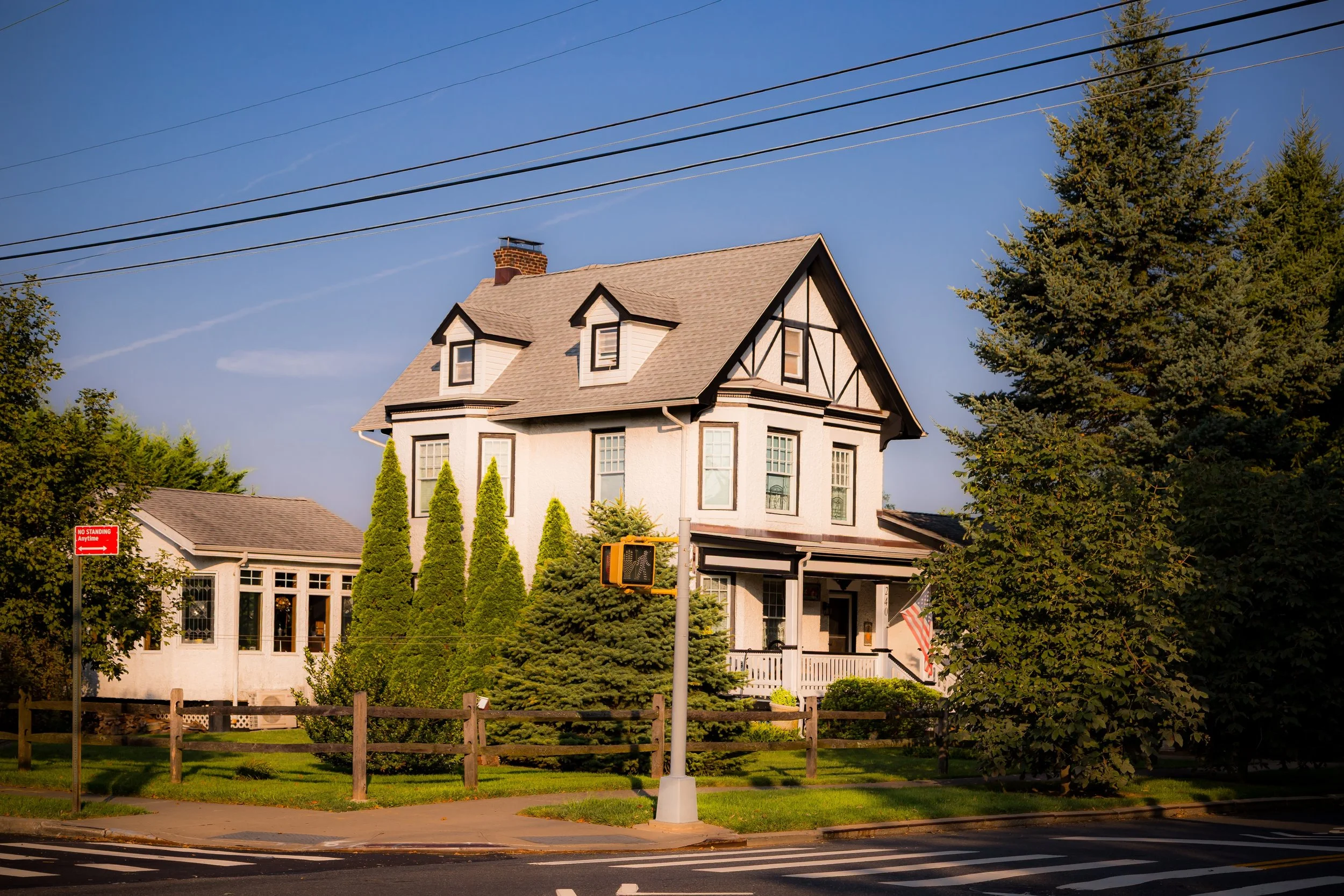
The defining change came in 1860, with the completion of the Staten Island Railway, which ran parallel to Amboy Road. The opening of the Oakwood Heights station transformed the area into a commuter suburb, attracting families from Manhattan and Brooklyn who sought affordable homes in a rural setting. Small cottages, inns, and general stores clustered around the station, while larger estates occupied the wooded high ground to the west. The name Oakwood Heights became synonymous with suburban promise—a quiet retreat within reach of the city.
Early 20th Century: Suburb by the Shore
In the early decades of the 20th century, Oakwood evolved from a semi-rural village into a stable residential neighborhood. The Staten Island Railway spurred steady population growth, and new streets—Guyon Avenue, Mill Road, and Tysens Lane—were laid out in an orderly grid. Modest single-family homes, often built by local craftsmen, reflected early 20th-century vernacular styles: wood-frame colonials, bungalows, and stucco cottages shaded by oaks and elms.
The community’s character was shaped by its balance of nature and domestic life. Residents could walk to the bayfront for clamming or swimming, yet still commute by rail to Manhattan jobs. Churches such as St. Charles Roman Catholic Church (founded in 1920) became social and spiritual anchors, serving a predominantly Irish and Italian working- and middle-class population. Small shops and bakeries along Guyon and Amboy Avenues supplied everyday needs, reinforcing the neighborhood’s self-contained feel.
At the same time, Oakwood retained vestiges of its rural past. Farms and woodlots still bordered the southern end of the neighborhood near the marshes, and open meadows stretched toward what is now Great Kills Park. Its blend of pastoral openness and civic order made Oakwood a model of early 20th-century suburban living—a place where nature’s rhythm remained audible amid the city’s steady expansion.
Oakwood Video Coming Soon
Mid–Late 20th Century: Suburbanization and Environmental Awareness
The postwar years brought profound transformation to Oakwood and the surrounding South Shore. The Verrazzano-Narrows Bridge (1964) opened Staten Island to a surge of new residents from Brooklyn, and Oakwood—already accessible by rail and road—saw an influx of middle-class families seeking suburban tranquility within New York City limits. Developers built new subdivisions west of Guyon Avenue, replacing remaining farmland with neat rows of ranch houses, split-levels, and brick colonials.
Despite suburban growth, Oakwood maintained a distinctive equilibrium: its older core near Amboy Road preserved its early-20th-century character, while newer tracts expanded the population without overwhelming the landscape. Civic associations and parish groups played a vital role in sustaining the neighborhood’s identity and safety during this period of rapid change.
Yet the natural environment that had long defined Oakwood became a focus of increasing concern. The coastal zone—particularly Oakwood Beach and the wetlands along Mill Creek—proved vulnerable to flooding and storm damage. By the late 20th century, many bayfront homes faced recurrent inundation, and environmental advocates began calling for restoration and managed retreat. The creation of Great Kills Park (1972) as part of the Gateway National Recreation Area both preserved large swaths of shoreline and signaled a shift toward ecological stewardship along the South Shore.
21st Century: Resilience, Renewal, and the Living Shoreline
The 21st century has defined Oakwood as both a community of tradition and a laboratory for coastal resilience. The neighborhood’s inland residential sections—centered around St. Charles Church, Oakwood Heights, and the Oakwood train station—remain among Staten Island’s most stable, marked by well-kept homes, good schools, and enduring civic pride. Its coastal edge, however, has undergone profound transformation.
The devastation of Hurricane Sandy (2012) profoundly reshaped Oakwood’s shoreline identity. The storm’s surge inundated much of Oakwood Beach, destroying homes and infrastructure. In the aftermath, residents participated in the New York State Buyout Program, voluntarily selling flood-prone properties for conversion into open space. The result has been a remarkable rewilding: former residential blocks have returned to meadow and marsh, forming part of an expanding Bluebelt system designed to manage stormwater naturally while restoring coastal habitats.
Today, the Oakwood Beach Bluebelt and adjacent Great Kills Park represent some of New York City’s most innovative environmental projects—landscapes where tidal wetlands, restored dunes, and retention basins function as living defenses against sea-level rise. The area now hosts saltmarsh sparrows, egrets, and diamondback terrapins where homes once stood, blending memory and regeneration in equal measure.
Meanwhile, the inland community continues to thrive, its leafy streets and small businesses maintaining the rhythm of daily life much as they have for a century. Families gather for parish festivals, students walk to local schools, and the scent of sea air mingles with the hum of suburban quiet.
Oakwood Photo Gallery
Spirit and Legacy
The spirit of Oakwood lies in its endurance—its ability to evolve while remaining grounded in place. From wooded uplands to seaside suburb, from storm-wracked beach to restored wetland, it has continually adapted to the shifting dialogue between land and water. Its people—farmers, commuters, builders, and now environmental stewards—have shaped and reshaped its story while preserving its essential calm.
Oakwood’s legacy is one of coexistence: between city and shore, home and habitat, memory and renewal. It stands as a living reminder that resilience is not merely survival but transformation—the capacity to restore balance in a changing world.

New York City
Use this custom Google map to explore where every neighborhood in all five boroughs of New York City is located.
The Five Boroughs
One of New York City’s unique qualities is its organization in to 5 boroughs: Manhattan, Brooklyn, Queens, The Bronx, and Staten Island. These boroughs are part pragmatic administrative districts, and part vestiges of the region’s past. Each borough is an entire county in New York State - in fact, Brooklyn is, officially, Kings County, while Staten Island is, officially Richmond County. But that’s not the whole story …
Initially, New York City was located on the southern tip of Manhattan (now the Financial District) that was once the Dutch colony of New Amsterdam. Across the East River, another city was rising: Brooklyn. In time, the city planners realized that unification between the rapidly rising cities would create commercial and industrial opportunities - through streamlined administration of the region.
So powerful was the pull of unification between New York and Brooklyn that three more counties were pulled into the unification: The Bronx, Queens, and Staten Island. And on January 1, 1898, the City of New York unified two cities and three counties into one Greater City of New York - containing the five boroughs we know today.
But because each borough developed differently and distinctly until unification, their neighborhoods likewise uniquely developed. Today, there are nearly 390 neighborhoods, each with their own histories, cultures, cuisines, and personalities - and each with residents who are fiercely proud of their corner of The Big Apple.


