JAMAICA CENTER
Queens
Geographic Setting
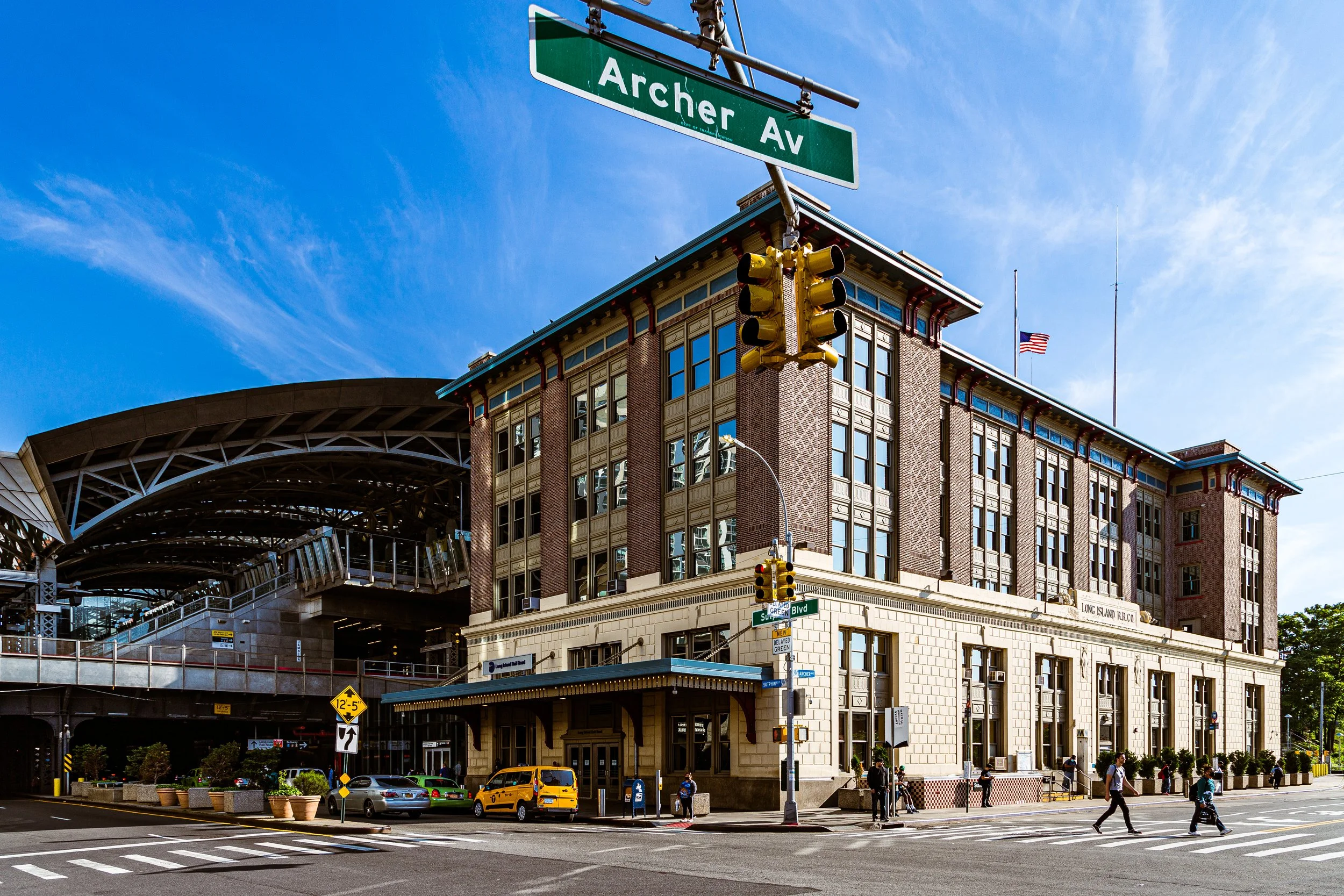
Bounded by Archer Avenue to the south, the Van Wyck Expressway to the west, Hillside Avenue to the north, and 180th Street to the east, Jamaica Center forms the historic and commercial core of Jamaica, and by extension, one of the most vital urban districts in Queens. Anchored by Jamaica Avenue, the neighborhood stands at the intersection of transportation, commerce, and civic life—a dense, energetic downtown where the borough’s history and its modern multicultural pulse converge.
At its heart runs Jamaica Avenue, a thoroughfare that has served as the area’s main street since colonial times. Today it remains lined with a vivid mix of retail shops, street vendors, and department stores, while civic landmarks—the Queens County Supreme Court, Central Library of Queens, and King Manor Museum—define its sense of continuity and place. The elevated J and Z subway lines rumble overhead, while the E line, AirTrain JFK, and Long Island Rail Road Jamaica Station to the west ensure that Jamaica Center functions as one of New York City’s most important transportation hubs.
The neighborhood’s built environment is an eclectic blend of early 20th-century commercial architecture, mid-century civic buildings, and 21st-century mixed-use developments. North of Jamaica Avenue, Hillside Avenue hosts banks, offices, and apartment houses; to the south, Archer Avenue—expanded in the 1980s as part of the Archer Avenue Subway Extension—serves as both a major transit artery and the gateway to the wider Jamaica community. In its density, rhythm, and resilience, Jamaica Center stands as both a downtown and a crossroads—a place where the borough’s civic institutions, cultural identity, and economic vitality meet.
Etymology and Origins
The term “Jamaica Center” reflects the area’s historical role as the center of the old Town of Jamaica, founded by English settlers in 1656 on land originally inhabited by the Lenape people, who called it “Yameco,” meaning “beaver” or “beaver water.” From its beginnings, this intersection of trails—modern-day Jamaica Avenue and Sutphin Boulevard—served as a focal point of trade and travel across Long Island.
Throughout the 18th and 19th centuries, Jamaica evolved from a farming village into a bustling market town. Jamaica Avenue—once the Jamaica Plank Road—connected the Atlantic coast at Brooklyn to eastern Long Island, making the settlement a natural hub for commerce, carriage traffic, and civic activity. The establishment of the Long Island Rail Road in the 1830s and the Queens County Courthouse in 1872 elevated the district’s prominence. By the late 19th century, “Jamaica Center” had come to denote both the town’s civic square and its surrounding commercial district—a title it has retained through every phase of the borough’s evolution.
The Neighborhood
Early 20th Century: The Borough’s Downtown
In the early decades of the 20th century, Jamaica Center emerged as the de facto downtown of Queens, its civic and commercial institutions drawing people from across the borough. Jamaica Avenue became Queens’ premier shopping corridor, lined with grand department stores such as Gertz, Mays, and E.J. Korvette, along with ornate theaters like the Loew’s Valencia (1929)—a lavish atmospheric movie palace that remains a beloved landmark.
The surrounding streets filled with office buildings, banks, and professional services, while civic institutions—the Queens Public Library’s Central Branch (1930), the Borough Courthouse, and numerous churches—cemented the area’s role as the administrative and cultural center of Queens. Public transit followed suit: the BMT Jamaica Elevated Line (now the J/Z) was extended eastward, bringing the rest of Brooklyn and Manhattan within easy reach.
During this period, Jamaica Center’s built environment reflected confidence and prosperity. Elegant Art Deco and Beaux-Arts façades lined Jamaica Avenue, while nearby neighborhoods such as Hollis, St. Albans, and Briarwood depended on Jamaica Center as their marketplace and transportation hub.
Mid-20th Century: Transformation, Challenge, and Continuity
By the mid-20th century, Jamaica Center remained a bustling commercial hub but faced the challenges of urban change. The postwar rise of suburban shopping malls and highways diverted consumer traffic, and the construction of the Van Wyck Expressway in the 1940s carved a physical boundary along its western edge. Still, Jamaica Center persisted as an essential retail and transit destination for southeastern Queens and Nassau commuters.
The 1960s and 1970s brought demographic transformation, as African-American and Caribbean-American families became the dominant presence in surrounding neighborhoods. Amid periods of disinvestment citywide, Jamaica Center retained its role as the cultural and commercial heart of Black Queens—a place of churches, barber shops, record stores, and civic pride. Local activism kept the area’s institutions alive, while the creation of York College (CUNY) just south of Archer Avenue in the 1970s renewed its educational influence.
The 1970s and 1980s also saw major infrastructure projects intended to modernize and revive the area. The Archer Avenue Subway Extension, completed in 1988, relocated portions of the J and Z lines underground and introduced the E train terminus at Jamaica Center–Parsons/Archer, reshaping the district’s street-level landscape. Concurrently, the Jamaica Center Business Improvement District (BID) was established to maintain storefronts, improve lighting, and attract investment.
Jamaica Center Photographic Video
Late 20th–21st Century: Renewal and Modern Identity
The turn of the millennium brought a wave of revitalization that has redefined Jamaica Center as both a local and regional hub. The completion of the AirTrain JFK (2003) connected Jamaica Station directly to John F. Kennedy International Airport, positioning the area as an essential gateway between Manhattan and the world. This new connectivity sparked public and private redevelopment—new office towers, hotels, and retail complexes began to rise along Archer Avenue and Parsons Boulevard, complementing the preserved historic fabric along Jamaica Avenue.
Cultural renewal accompanied physical change. The restoration of the Loew’s Valencia Theatre—now operated as the Tabernacle of Prayer Church—and the opening of the Jamaica Performing Arts Center (JPAC) within a landmarked Dutch Reformed Church underscored the district’s commitment to both heritage and creativity. The Central Library, one of the busiest in the nation, remains a civic anchor, while nearby King Manor Museum, set amid Rufus King Park, connects residents to Jamaica’s colonial and abolitionist past.
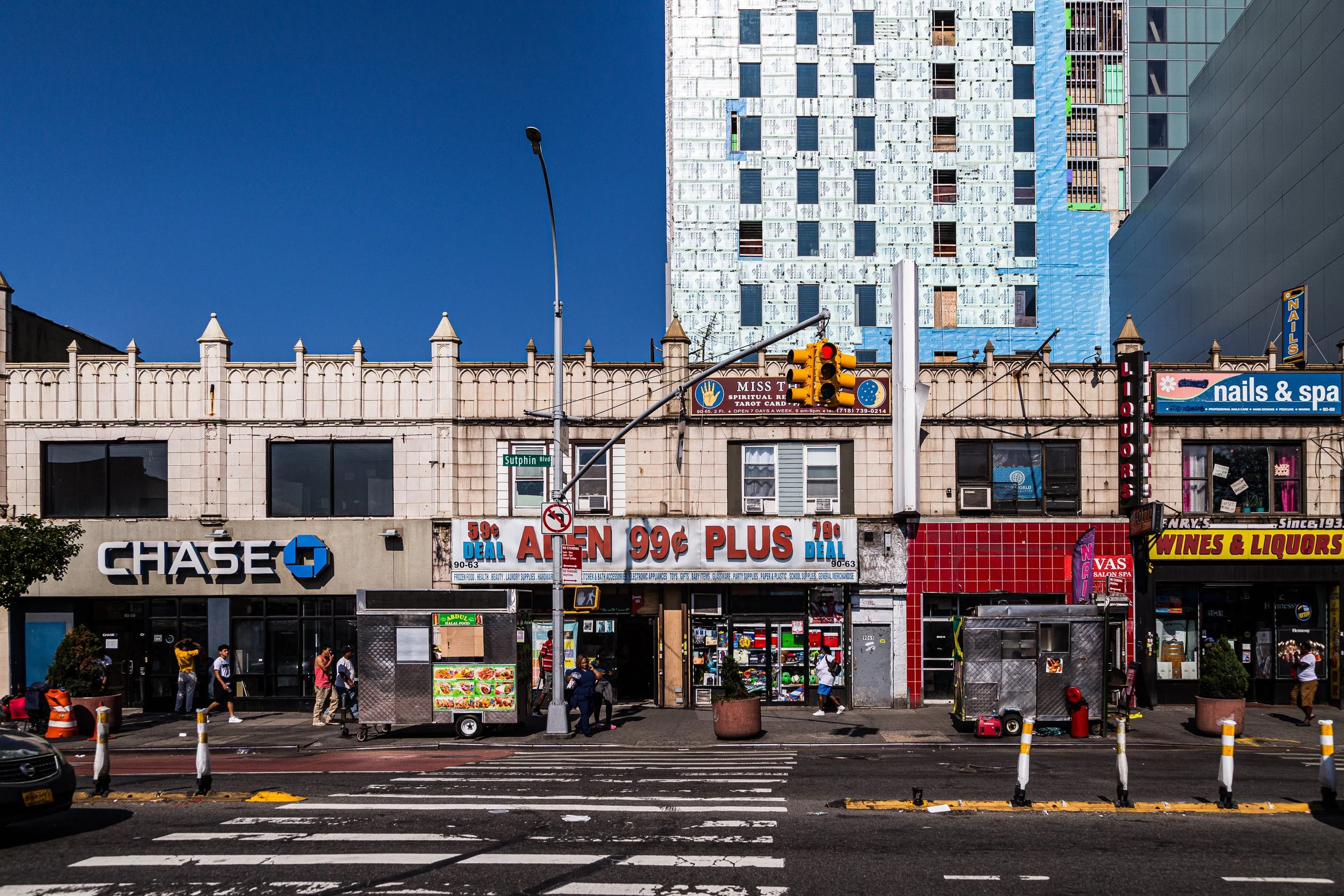
The 21st century has also seen a surge in residential development, with new mixed-use towers rising along Sutphin and Archer. The Downtown Jamaica Plan (2007) and subsequent rezoning spurred investment while emphasizing pedestrian spaces, affordable housing, and small-business support. Today, Jamaica Center’s economy is powered by both its legacy retailers and its entrepreneurial diversity: Caribbean, Bangladeshi, Latin American, and South Asian businesses form the backbone of the district’s street-level culture.
Jamaica Center Photo Gallery
Spirit and Legacy
Jamaica Center’s spirit lies in its continuity through change. For more than three centuries, this district has been a hub of commerce, governance, and community—a place where the borough gathers, debates, and trades. From horse-drawn wagons on the Jamaica Plank Road to subways and AirTrains, it has remained Queens’ front door to the city and the world.
Today, amid the hum of traffic and the din of merchants calling out along Jamaica Avenue, the district retains the energy of a living marketplace layered over centuries of history. Rufus King Park offers quiet reflection beneath ancient elms; a few blocks away, the glow of storefronts and the rhythm of the elevated train remind visitors that this has always been—and remains—the beating heart of southeastern Queens.
At dusk, as commuters stream from the E, J, and Z trains and vendors close their stalls beneath the amber streetlights, Jamaica Center embodies the essence of urban life: industrious, diverse, resilient, and alive with history still unfolding.
New York City
Use this custom Google map to explore where every neighborhood in all five boroughs of New York City is located.
The Five Boroughs
One of New York City’s unique qualities is its organization in to 5 boroughs: Manhattan, Brooklyn, Queens, The Bronx, and Staten Island. These boroughs are part pragmatic administrative districts, and part vestiges of the region’s past. Each borough is an entire county in New York State - in fact, Brooklyn is, officially, Kings County, while Staten Island is, officially Richmond County. But that’s not the whole story …
Initially, New York City was located on the southern tip of Manhattan (now the Financial District) that was once the Dutch colony of New Amsterdam. Across the East River, another city was rising: Brooklyn. In time, the city planners realized that unification between the rapidly rising cities would create commercial and industrial opportunities - through streamlined administration of the region.
So powerful was the pull of unification between New York and Brooklyn that three more counties were pulled into the unification: The Bronx, Queens, and Staten Island. And on January 1, 1898, the City of New York unified two cities and three counties into one Greater City of New York - containing the five boroughs we know today.
But because each borough developed differently and distinctly until unification, their neighborhoods likewise uniquely developed. Today, there are nearly 390 neighborhoods, each with their own histories, cultures, cuisines, and personalities - and each with residents who are fiercely proud of their corner of The Big Apple.


