RANDALLS AND WARDS ISLANDS
Manhattan
Geographic Setting
Set at the confluence of the Harlem River, East River, and Bronx Kill, Randall’s Island occupies one of New York City’s most geographically strategic and visually striking locations. Though formally part of Manhattan, the island lies off its northeastern shore, connected by bridges to East Harlem, the South Bronx, and Astoria, Queens. It is bordered to the west by the Harlem River, to the north by the Bronx Kill, and to the east by the main channel of the East River, with the Hell Gate Bridge arcing dramatically above its eastern edge.
Together with its conjoined neighbor Wards Island—the two separated only by a narrow inlet until the 1930s—Randall’s forms a vast expanse of parkland, athletic fields, and public facilities surrounded by tidal currents and skyline views. The island’s long, low profile—flat fields, riverfront paths, and windswept lawns—stands in deliberate contrast to Manhattan’s density. With its bridges, highways, and green spaces, Randall’s Island functions as both gateway and refuge: an urban park at the city’s literal crossroads.
Etymology and Origins
Randall’s Island takes its name from Jonathan Randel (also spelled Randall), a British army sergeant who received the land as a grant in 1772. The Randall family farmed here for decades before selling it to the city in 1835, when urban expansion and social reform movements began transforming the small islands of the East River into institutional sites. Early maps show Randall’s and neighboring Wards Island as separate, marsh-fringed parcels—their fertile soils once part of a broader archipelago known for shellfish beds and tidal meadows.
The Randall family’s modest farmstead gave way to an era of institutional use that would define the island’s 19th-century identity: a place of asylums, orphanages, hospitals, and reformatories, meant to isolate the vulnerable from the temptations and diseases of the mainland city. Its name thus carries a double legacy—agrarian origins overlaid by civic purpose.
The Neighborhood
19th Century: Reform, Isolation, and Institutional Landscapes
In the 19th century, Randall’s Island became a microcosm of New York’s social conscience. Following its purchase in 1835, the city erected the House of Refuge for Juvenile Delinquents (opened 1854), the first reformatory of its kind in the nation. The island’s separation by water was seen as a moral safeguard, a space for discipline and rehabilitation. Over the following decades, other institutions followed: the Idiots’ Asylum (later the Randall’s Island Hospital for Children), a poorhouse, and facilities for the mentally ill and infirm.
The island’s layout reflected Victorian ideas of moral order and public health. Institutional buildings stood in orderly rows facing the river, surrounded by lawns and gardens intended to inspire calm. Bridges connected Randall’s to Wards Island, which housed the New York City Asylum for the Insane (1847) and the Metropolitan Hospital complex. Together, the twin islands formed a self-contained world of caretakers and patients—half prison, half sanctuary.
By the 1870s, the city’s Department of Charities and Correction managed the islands jointly. Ferries from East Harlem transported supplies and staff, while steam launches patrolled the river channels. Though isolated, Randall’s Island was hardly forgotten: its institutions featured prominently in 19th-century reform literature, emblematic of both the city’s compassion and its contradictions.
Early 20th Century: Athletic Aspirations and Public Works
The early 1900s brought a profound shift in function and philosophy. As medical and social reforms centralized services elsewhere, city planners reimagined Randall’s Island as a recreational and infrastructural hub. In 1930, the two islands were officially joined by landfill under the direction of Robert Moses, Commissioner of Parks and Public Works. His sweeping Randall’s and Wards Island Redevelopment Plan transformed the combined landmass into a public park and athletic complex for the people of New York.
The centerpiece of this transformation was Triborough Bridge (now Robert F. Kennedy Bridge), opened in 1936, linking Manhattan, Queens, and the Bronx in one of the great engineering achievements of the century. Beneath its steel towers, Moses built baseball diamonds, soccer fields, and the Triborough Stadium (later Downing Stadium), which hosted the 1936 U.S. Olympic trials and countless civic events. In the same year, Randall’s Island Park was dedicated—a symbol of Depression-era optimism and urban planning grandeur.
Throughout the mid-century decades, Randall’s Island served as a multipurpose civic space. It hosted outdoor concerts, track meets, and the Randall’s Island Music Festival of 1938. Yet it also continued to house state and city institutions, including the Manhattan State Hospital Annex and, later, a fire academy, police training grounds, and Department of Sanitation facilities—a testament to the island’s ongoing role as the city’s functional hinterland.
Randalls & Wards Islands Photographic Tour
Late 20th Century: Neglect and Renewal
By the 1970s, decades of heavy use and limited maintenance left Randall’s Island in decline. Downing Stadium, once a civic showcase, fell into disrepair, and large portions of the park were inaccessible or underutilized. Yet the island’s potential as green space never disappeared. Civic leaders and environmental advocates pushed for restoration, emphasizing its role as a natural habitat and recreational resource.
In the 1990s, the Randall’s Island Sports Foundation (now the Randall’s Island Park Alliance) was established to rehabilitate and manage the park. Their efforts led to extensive ecological and recreational renewal: restoration of salt marshes and wetlands, new athletic fields, and miles of pedestrian and bicycle paths along the waterfront. The Icahn Stadium, opened in 2005 on the site of Downing Stadium, reestablished the island as the city’s premier track-and-field venue, hosting international competitions and community events alike.
Simultaneously, the island became a stage for art and music festivals such as Frieze New York and Governors Ball, bringing new cultural visibility to its once-isolated landscape.
21st Century: Ecology, Recreation, and Connection
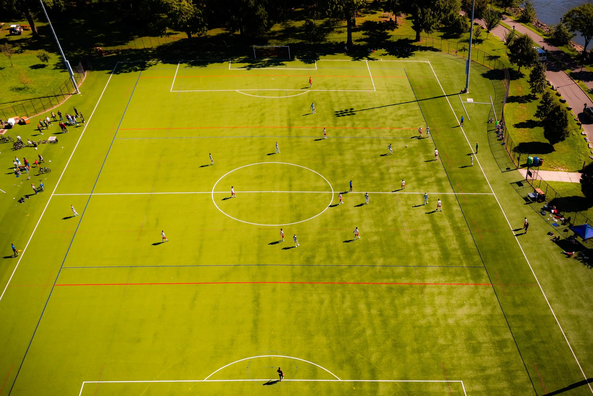
Today, Randall’s Island represents one of New York’s great success stories in urban ecology and public access. More than 60 athletic fields accommodate soccer, baseball, and lacrosse, while waterfront promenades link seamlessly to the East River Greenway. Native wetlands and restored tidal habitats host egrets, herons, and migratory birds, making the island an unexpected ecological haven in the heart of the metropolis.
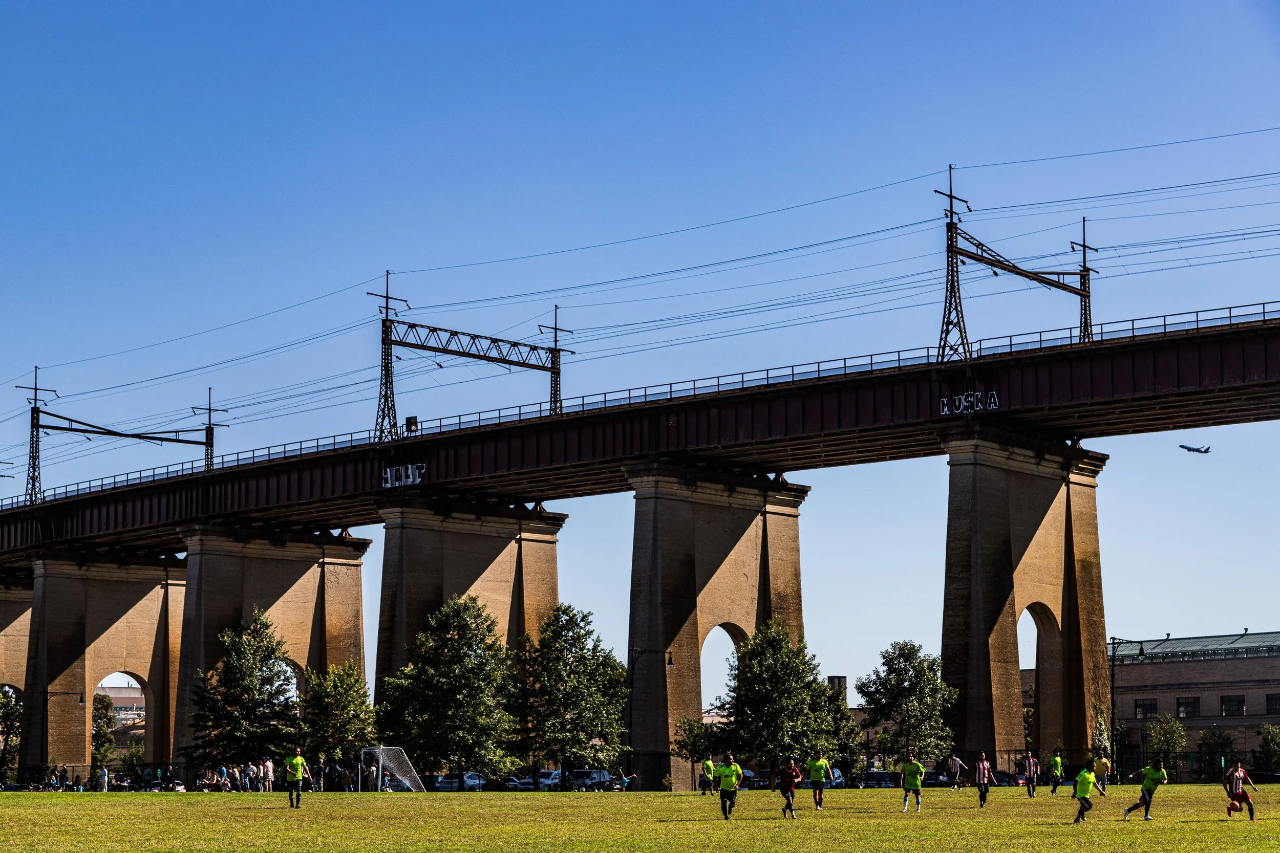
Infrastructure continues to define its silhouette: the red arc of the Hell Gate Bridge, the trusses of the RFK Bridge, and the steady hum of expressways overhead. Yet at ground level, the atmosphere is pastoral—open skies, breezes, and the scent of the river. Civic institutions such as the FDNY Training Academy, NYPD facilities, and City Parks Department headquarters coexist with playgrounds, gardens, and event spaces. The island has also become a focal point for resilience planning, with flood mitigation and shoreline protection projects ensuring its long-term sustainability in a changing climate.
Randalls & Wards Islands Photo Gallery
Spirit and Legacy
Randall’s Island embodies New York’s paradox of isolation and interconnection. Once a haven for society’s forgotten, then a playground for its multitudes, it has continually reflected the city’s evolving ideals—charity, progress, recreation, and renewal. Its bridges link not only boroughs but eras: from colonial farmland to reformist institutions, from Robert Moses’ monumental modernism to today’s ecological stewardship.
New York City
Use this custom Google map to explore where every neighborhood in all five boroughs of New York City is located.
The Five Boroughs
One of New York City’s unique qualities is its organization in to 5 boroughs: Manhattan, Brooklyn, Queens, The Bronx, and Staten Island. These boroughs are part pragmatic administrative districts, and part vestiges of the region’s past. Each borough is an entire county in New York State - in fact, Brooklyn is, officially, Kings County, while Staten Island is, officially Richmond County. But that’s not the whole story …
Initially, New York City was located on the southern tip of Manhattan (now the Financial District) that was once the Dutch colony of New Amsterdam. Across the East River, another city was rising: Brooklyn. In time, the city planners realized that unification between the rapidly rising cities would create commercial and industrial opportunities - through streamlined administration of the region.
So powerful was the pull of unification between New York and Brooklyn that three more counties were pulled into the unification: The Bronx, Queens, and Staten Island. And on January 1, 1898, the City of New York unified two cities and three counties into one Greater City of New York - containing the five boroughs we know today.
But because each borough developed differently and distinctly until unification, their neighborhoods likewise uniquely developed. Today, there are nearly 390 neighborhoods, each with their own histories, cultures, cuisines, and personalities - and each with residents who are fiercely proud of their corner of The Big Apple.


