DYKER HEIGHTS
Brooklyn
Geographic Setting
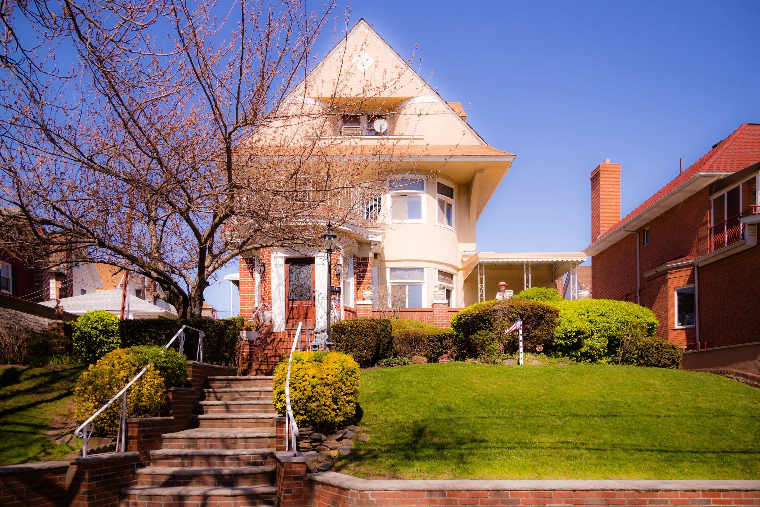
Bounded by the Gowanus Expressway to the west and 14th Avenue to the east, and stretching from 65th Street south to 86th Street, Dyker Heights occupies a commanding position atop the rolling plateau between Bay Ridge and Bensonhurst—a neighborhood defined by gracious homes, manicured lawns, and a sense of suburbia within the city. Its quiet, tree-lined streets descend gently toward New York Harbor, offering distant glimpses of the Verrazzano-Narrows Bridge and Staten Island beyond. Though surrounded by dense, working-class districts, Dyker Heights has maintained a singular identity since its founding at the turn of the 20th century: a planned residential enclave built for comfort, elegance, and continuity.
The neighborhood’s geography is both literal and symbolic. Rising higher than the surrounding lowlands, Dyker Heights forms part of the ancient glacial ridge that once shaped Brooklyn’s topography. Its broad avenues—11th through 14th Avenues—are lined with detached and semi-detached houses in styles ranging from Colonial Revival to Mediterranean villa, Tudor, and midcentury brick. Yards and driveways replace the stoops of denser neighborhoods, and the scent of lilac, pine, and pastry mingles in the air. The centerpiece of community life is Dyker Beach Park and Golf Course, a vast 217-acre expanse along the western edge that serves as both green refuge and the symbolic heart of the neighborhood.
Etymology and Origins
The name Dyker Heights derives from the old “Dykes Meadows”, Dutch-era farmlands located near the tidal inlets that once stretched from the Narrows inland. The term “Dyker” comes from the dikes and drainage ditches built by 17th-century Dutch settlers to reclaim marshy coastal land for agriculture. By the 19th century, these meadows formed part of the rural holdings of the Bennet, Polhemus, and Van Brunt families—names still found throughout southern Brooklyn.
The modern neighborhood owes its existence to Walter L. Johnson, a developer and civic booster who, in 1895, purchased farmland atop the ridge and laid out a suburban-style community modeled on the ideals of the City Beautiful movement. Johnson envisioned “country living within the city,” a place of single-family homes, tree-lined streets, and restrictive covenants ensuring architectural harmony. His Dyker Heights Company marketed the development to Brooklyn’s rising professional class—lawyers, bankers, and merchants seeking tranquility without sacrificing urban convenience.
The Neighborhood
Late 19th Century: The Birth of a Suburban Ideal
Development began in earnest in the 1890s, as Johnson’s firm parceled the ridge into spacious lots with panoramic harbor views. Early houses were large Queen Anne and Colonial Revival residences, featuring porches, turrets, and lawns—an aesthetic departure from the tight brownstone rows of northern Brooklyn. The extension of electric trolley lines along 13th and 14th Avenues and the opening of the Fourth Avenue subway line (1915) made Dyker Heights easily accessible, further spurring growth.
A landmark of this era was the Dyker Heights Clubhouse, a social and real estate center promoting the district’s genteel character. Advertisements boasted “pure sea air,” “no tenements,” and “high-class improvements.” Churches, such as St. Philip’s Episcopal (1900) and Our Lady of Angels Roman Catholic Church (1906), anchored early civic life, while the adjoining Dyker Beach Park—established by the city in 1895—provided recreation and scenic vistas.
By 1905, Dyker Heights had become a model of suburban planning within New York City—its curving streets, uniform setbacks, and landscape planting setting a precedent for later residential developments like Marine Park and Forest Hills Gardens.
Early–Mid 20th Century: Consolidation and Character
Through the 1920s–1940s, Dyker Heights solidified its identity as one of Brooklyn’s most stable middle- and upper-middle-class neighborhoods. The original Victorian and Colonial homes were joined by more compact brick and stucco houses built in Renaissance Revival and Mediterranean styles, reflecting the architectural tastes of the era. The nearby Dyker Beach Golf Course, redesigned by John Van Kleek in 1935, gave the area an additional touch of prestige and open space.
The population shifted gradually as Italian-American families, many moving outward from Bay Ridge and Bensonhurst, purchased homes and established tight-knit community networks. Family-run bakeries, butchers, and restaurants along 13th Avenue became neighborhood institutions. Parish life flourished around churches such as St. Bernadette’s (founded 1937) and St. Ephrem’s (1921), both of which remain spiritual and social anchors.
During this period, Dyker Heights developed a reputation for immaculate lawns, strong civic associations, and low crime—qualities that distinguished it amid the industrial bustle of southern Brooklyn. Its modest affluence rested not on ostentation, but on stewardship: pride in homeownership, in block maintenance, and in the continuity of community traditions.

Dyker Heights Photographic Video
Late 20th Century: Preservation amid Suburbanization
The postwar decades brought new infrastructure and slow but steady change. The completion of the Gowanus Expressway (1941–1950s) carved a physical barrier along Dyker Heights’ western edge, cutting it off from the waterfront but shielding it from industrial traffic. The neighborhood, however, retained its residential calm.
By the 1960s–1980s, Dyker Heights was firmly identified with Brooklyn’s Italian-American middle class—characterized by family-run businesses, parish festivals, and multigenerational households. The rise of the Dyker Heights Civic Association (founded 1928, revitalized mid-century) ensured the preservation of zoning protections and architectural integrity, warding off large-scale redevelopment. Despite the city’s broader fiscal struggles, the neighborhood remained remarkably stable.
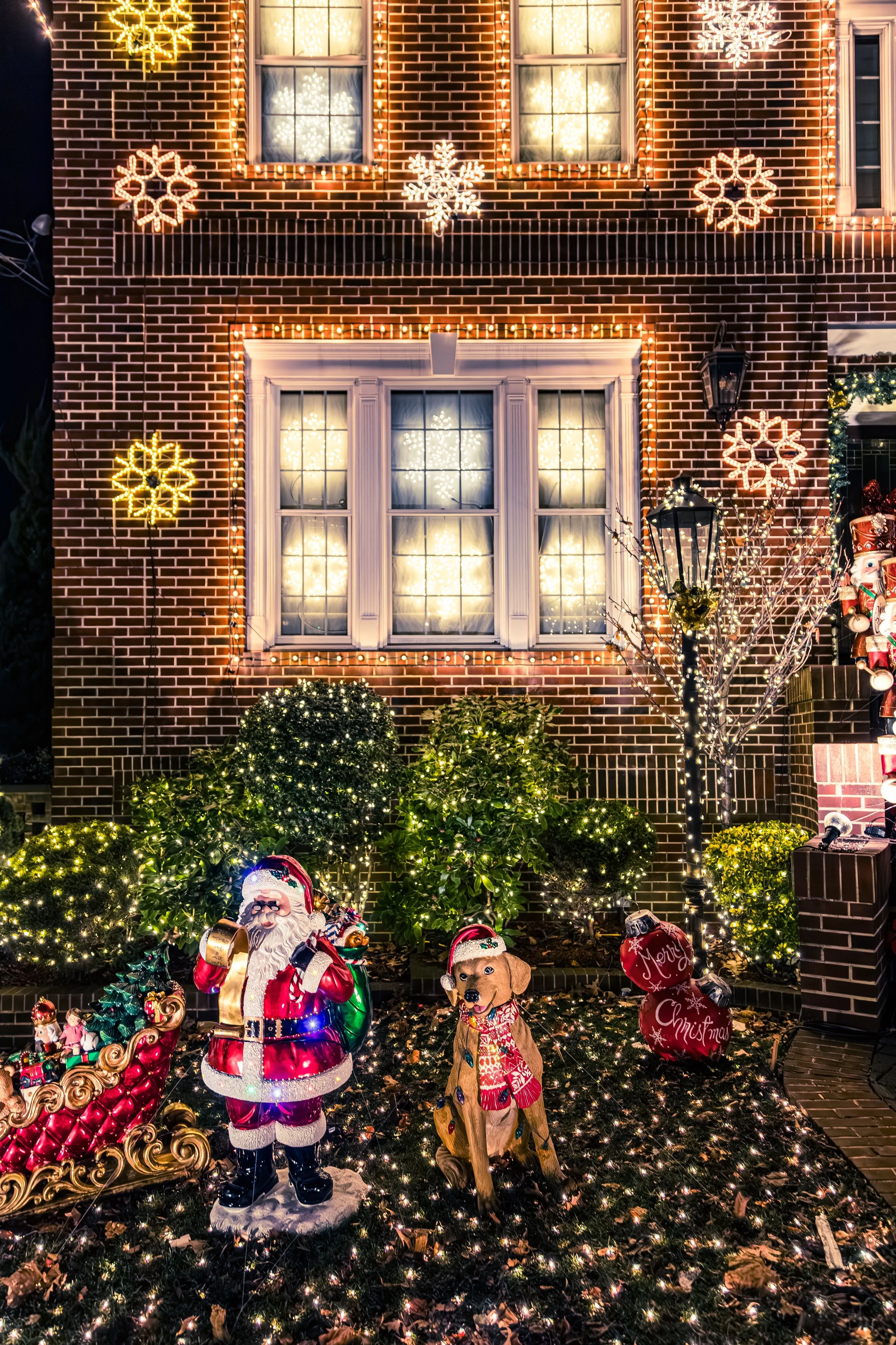
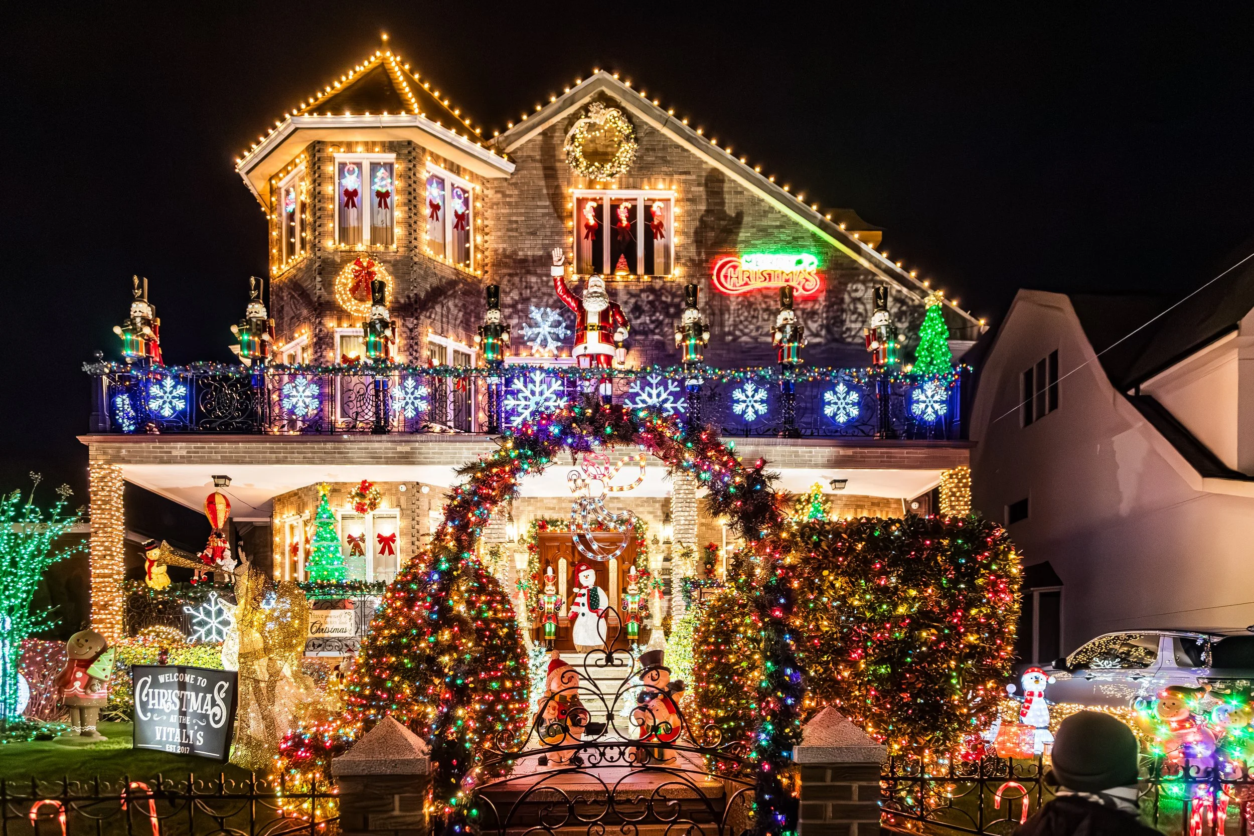
During these years, one local tradition grew into an international phenomenon: the Dyker Heights Christmas Lights. Beginning in the 1980s as a handful of elaborate home displays, the spectacle expanded into a community-wide event drawing thousands each December. Mansions along 84th to 86th Streets became canvases of electric wonder—nativity scenes, animated reindeer, and orchestral light shows transforming quiet residential blocks into a winter carnival. Today, the lights are both an emblem of neighborhood pride and a seasonal pilgrimage site for visitors from around the world.
21st Century: A Neighborhood of Continuity and Quiet Prestige
In the 21st century, Dyker Heights remains one of Brooklyn’s most distinctive enclaves—defined by single-family homes, strong institutions, and enduring social cohesion. While property values have risen sharply, the neighborhood’s character endures: detached houses with porches and driveways, family-owned bakeries, and the rhythms of daily life untroubled by the high-rise transformations elsewhere in the borough.
The population continues to evolve. While Italian-American families remain foundational, the neighborhood has seen growing Chinese, Russian, and Middle Eastern communities, reflecting Brooklyn’s broader demographic mosaic. Yet local culture—rooted in home, faith, and tradition—remains unmistakable. On summer evenings, residents still gather on stoops or stroll along 13th Avenue, chatting with neighbors over espresso or gelato. The Dyker Beach Golf Course continues as a green sanctuary, hosting both weekend golfers and community events.
Through careful zoning and civic vigilance, Dyker Heights has resisted overdevelopment, preserving its rare suburban feel within the five boroughs. The tree canopies along 81st Street, the front gardens trimmed with boxwood and rose, and the neighborhood’s elevated topography continue to embody the pastoral vision that Walter L. Johnson imagined more than a century ago.
Dyker Heights Photo Gallery
Spirit and Legacy
Dyker Heights’ legacy is one of graceful constancy. Founded as a suburban dream within the metropolis, it has remained true to its founding promise—a neighborhood defined not by wealth or spectacle but by care, order, and community pride. Its beauty lies in its restraint: clean streets, tended gardens, and homes that speak softly of continuity.
New York City
Use this custom Google map to explore where every neighborhood in all five boroughs of New York City is located.
The Five Boroughs
One of New York City’s unique qualities is its organization in to 5 boroughs: Manhattan, Brooklyn, Queens, The Bronx, and Staten Island. These boroughs are part pragmatic administrative districts, and part vestiges of the region’s past. Each borough is an entire county in New York State - in fact, Brooklyn is, officially, Kings County, while Staten Island is, officially Richmond County. But that’s not the whole story …
Initially, New York City was located on the southern tip of Manhattan (now the Financial District) that was once the Dutch colony of New Amsterdam. Across the East River, another city was rising: Brooklyn. In time, the city planners realized that unification between the rapidly rising cities would create commercial and industrial opportunities - through streamlined administration of the region.
So powerful was the pull of unification between New York and Brooklyn that three more counties were pulled into the unification: The Bronx, Queens, and Staten Island. And on January 1, 1898, the City of New York unified two cities and three counties into one Greater City of New York - containing the five boroughs we know today.
But because each borough developed differently and distinctly until unification, their neighborhoods likewise uniquely developed. Today, there are nearly 390 neighborhoods, each with their own histories, cultures, cuisines, and personalities - and each with residents who are fiercely proud of their corner of The Big Apple.


