PARK SLOPE
Brooklyn
Geographic Setting
Bounded by Prospect Park West and Flatbush Avenue to the east, Fourth Avenue to the west, Atlantic Avenue and the Flatbush Avenue Extension to the north, and 10th Avenue to the south, Park Slope unfolds along the gentle incline rising from Gowanus toward the emerald edge of Prospect Park. This slope—both literal and historical—defines one of Brooklyn’s most storied neighborhoods: a district of brownstone grace, civic idealism, and cultural continuity that reflects the evolution of urban America itself.
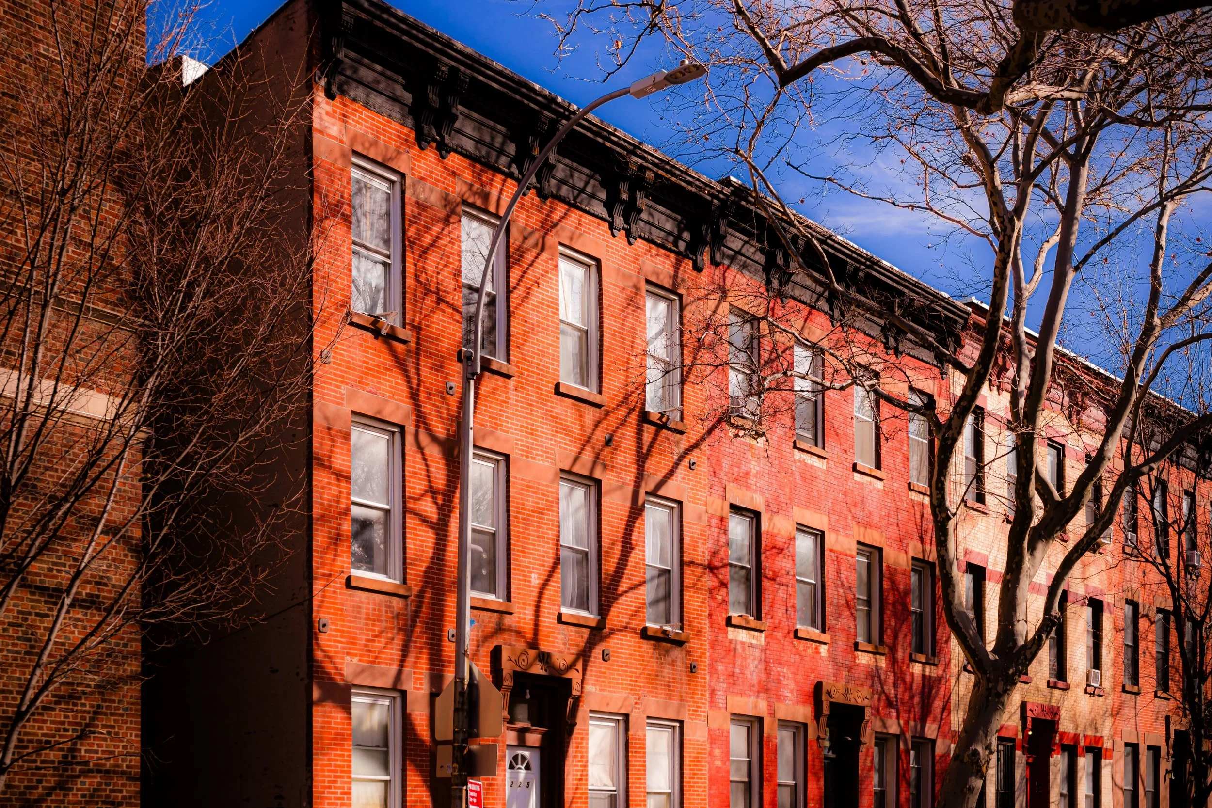
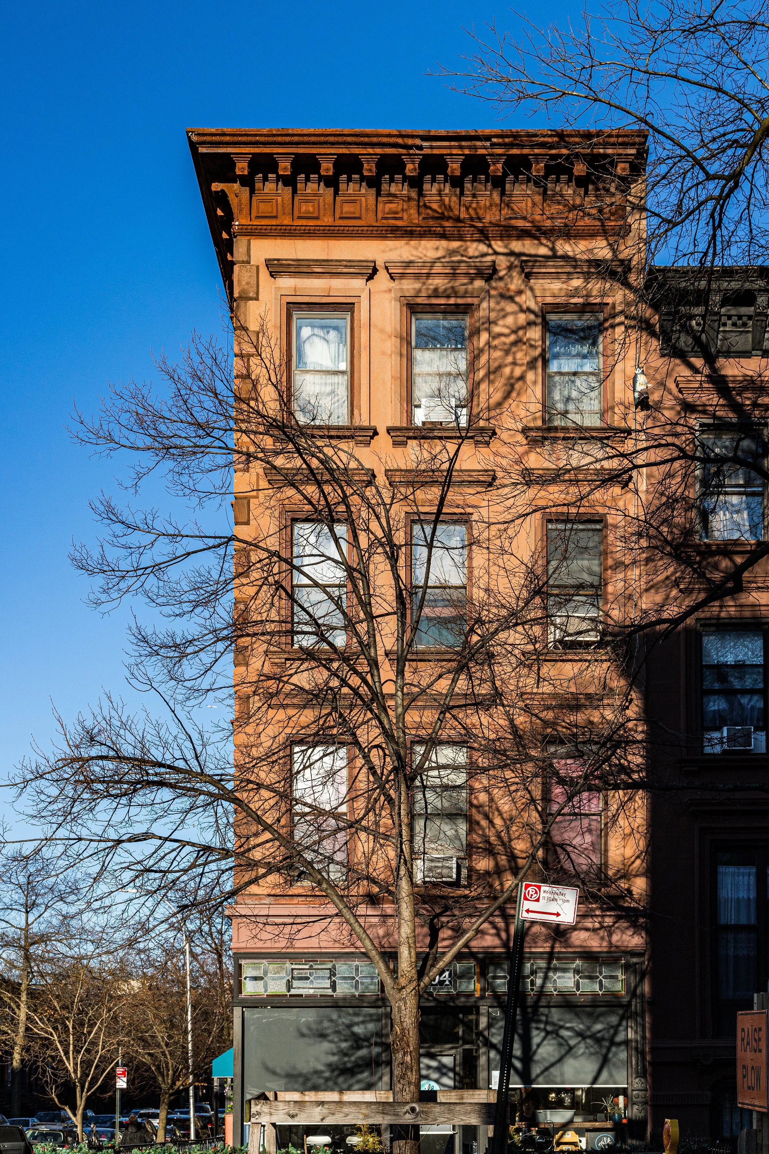
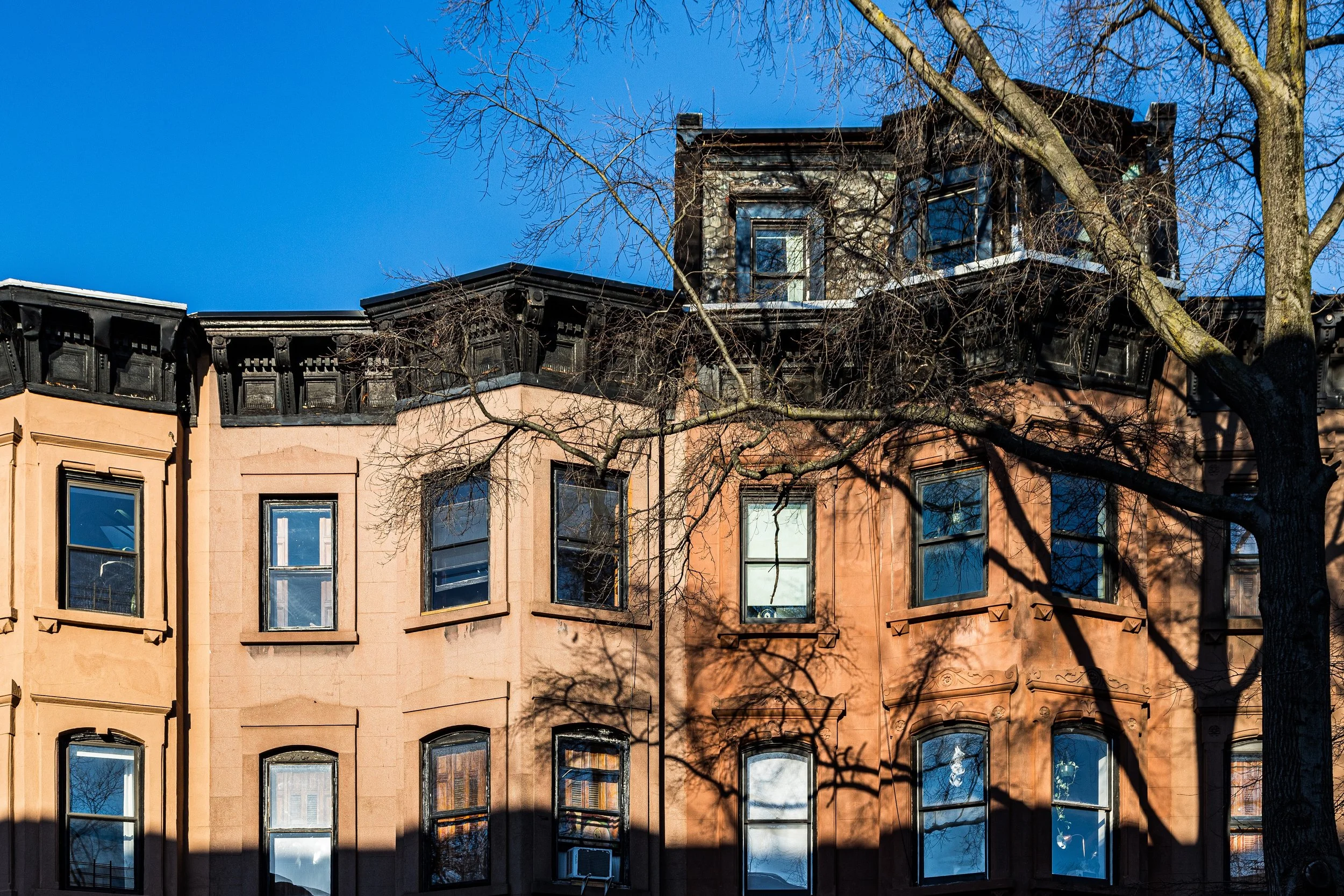
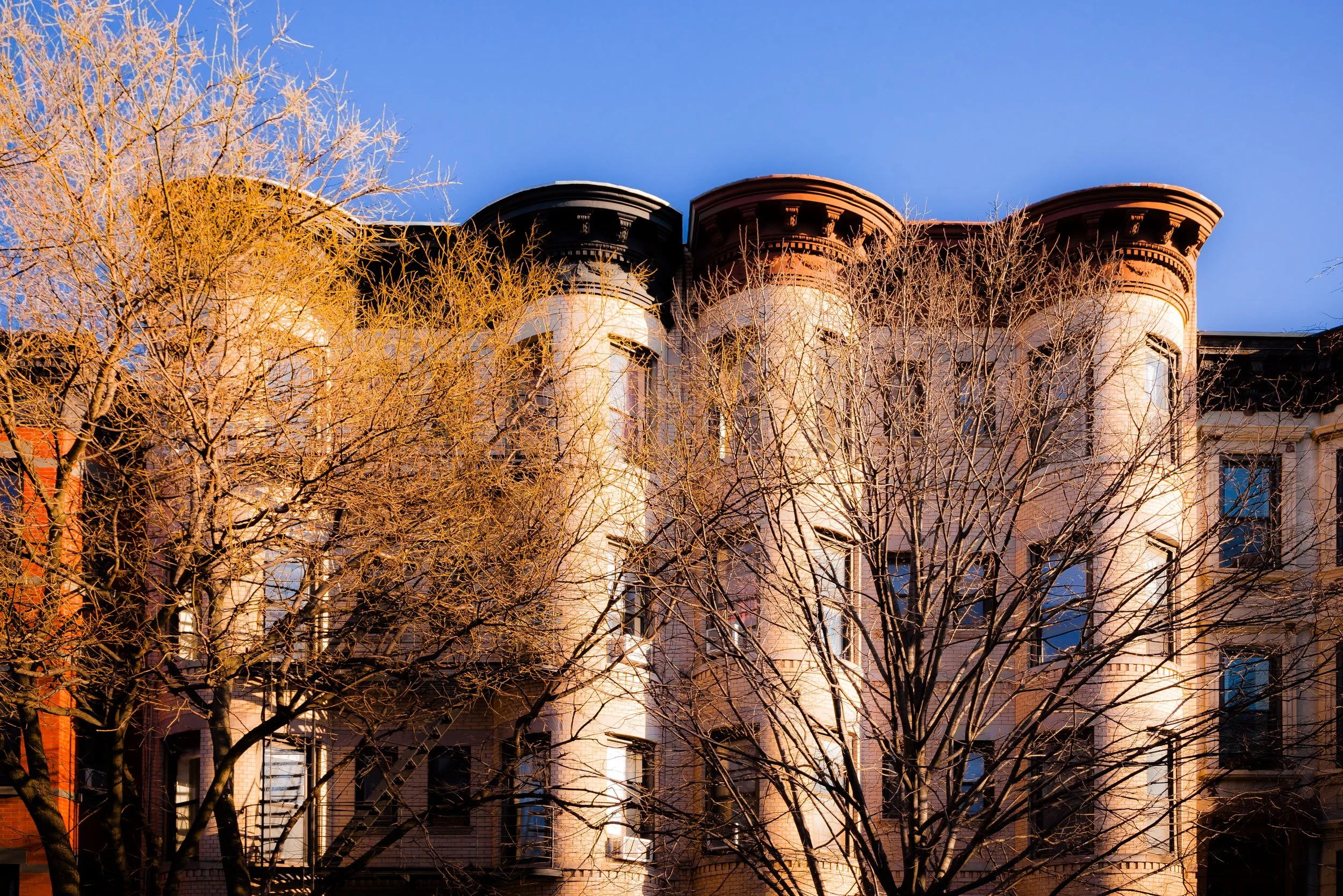
The streets ascend in rhythmic succession—1st through 10th Streets, Berkeley Place, Carroll Street, Garfield Place, and President Street—lined with rows of 19th-century brownstones and tree canopies that form one of the city’s most complete examples of late Victorian urban planning. At its eastern crest, the neighborhood meets Prospect Park, designed by Frederick Law Olmsted and Calvert Vaux, whose landscape vision remains its defining boundary and soul. Commercial corridors along Seventh Avenue, Fifth Avenue, and Union Street supply the hum of cafés, bookstores, and bakeries, while the Grand Army Plaza at the north end—framed by the Soldiers’ and Sailors’ Arch (1892)—forms both an entrance to the park and a civic gateway to Brooklyn itself.
Etymology and Origins
The name Park Slope arose naturally in the late 19th century, after the opening of Prospect Park (1867–1873), describing the upward “slope” of land from the industrial lowlands of Gowanus toward the park’s wooded crest. The area, however, predates the park by centuries: it formed part of the Dutch town of Breuckelen, settled in the 1600s, and remained farmland for nearly 200 years.
Through the 18th and early 19th centuries, large estates and working farms—owned by families like the Litchfields, Cortelyous, and Bergen—dominated the rolling terrain. One of the key figures in its early urbanization was Edwin Clark Litchfield, a railroad magnate who purchased much of the surrounding land in the 1850s and built Litchfield Villa, an Italianate mansion that still stands inside Prospect Park near 5th Street. Litchfield’s influence, combined with the arrival of public transit, laid the foundation for the neighborhood’s development.
The Neighborhood
19th Century: From Farmland to Brownstone Suburb
The transformation of Park Slope began after the completion of Prospect Park (1867–1873) and the extension of the Fifth Avenue Elevated Line and streetcar routes along Flatbush and Fourth Avenues. With these improvements, the once-rural hillside became Brooklyn’s most fashionable residential district—an “urban suburb” of quiet streets, leafy vistas, and ornate architecture.
Between 1870 and 1890, developers erected hundreds of brownstone and limestone rowhouses in Italianate, Neo-Grec, Romanesque Revival, and Queen Anne styles. Builders such as C.P.H. Gilbert, Montrose Morris, and William Flanagan designed facades that emphasized craftsmanship and variety—stoops with carved newels, arched doorways, stained-glass transoms, and intricate cornices. The result was a harmonious yet richly textured environment that remains one of the most admired residential streetscapes in the United States.
The opening of Grand Army Plaza in the 1890s—crowned by the Soldiers’ and Sailors’ Arch, bronze equestrian statues, and the beginnings of the Brooklyn Public Library complex—solidified the area’s prestige. Park Slope’s residents were a cross-section of the late 19th-century urban middle and upper classes: merchants, lawyers, clergy, and educators who prized the combination of civic proximity and pastoral calm. Churches such as St. Augustine’s Roman Catholic Church (1895) and Old First Reformed Church (1891) rose as architectural landmarks, while P.S. 39 (built 1877) reflected the neighborhood’s growing population of families.
By the turn of the century, Park Slope was recognized—along with Brooklyn Heights and Clinton Hill—as one of Brooklyn’s “Gold Coast” neighborhoods.
Early–Mid 20th Century: Stability, Decline, and Survival
The first decades of the 20th century saw Park Slope mature into a well-established residential quarter. Apartment buildings began appearing along the avenues, while the side streets retained their brownstone character. The 1908 extension of the BMT Fourth Avenue Subway Line made commuting to Manhattan even easier.
However, the Great Depression and postwar suburbanization altered the district’s fortunes. As wealthier families moved to outer boroughs and Long Island, many brownstones were converted into rooming houses or multifamily dwellings. By the 1950s–1960s, parts of Park Slope—particularly near Fourth Avenue and Gowanus—had fallen into disrepair. Yet the community’s social institutions persisted: churches, civic clubs, and small businesses maintained a neighborhood identity even amid economic decline.
A turning point came with the Brownstone Revival Movement of the 1960s–1970s, when urban homesteaders and preservation-minded residents began restoring the old houses block by block. The formation of the Park Slope Civic Council and the Park Slope Historic District (designated 1973) formalized these efforts, ensuring protection for over 2,000 buildings within the area’s core.
Park Slope Photographic Video
Late 20th Century: Revival and Renaissance
By the 1980s, Park Slope had reemerged as one of Brooklyn’s most desirable neighborhoods—an emblem of the city’s late-20th-century urban renewal. Artists, professionals, and young families drawn by affordable brownstones and proximity to Prospect Park reinvigorated the community. Cafés, bookstores, and independent shops flourished along Seventh Avenue, giving rise to the neighborhood’s enduring nickname, “The Slope.”
At the same time, long-term residents, particularly Irish, Italian, and Puerto Rican families, contributed to its continuity and texture. The mix of newcomers and old-timers produced a neighborhood culture defined by civic activism and progressive politics—values reflected in its reputation as one of New York’s most engaged and community-oriented districts.
By the 1990s, Park Slope’s revival was complete: restored facades gleamed, schools improved, and property values soared. The Park Slope Food Coop (founded 1973), both symbol and engine of local activism, embodied the area’s blend of idealism and self-sufficiency.
21st Century: Heritage and Transformation
In the 21st century, Park Slope has become synonymous with Brooklyn’s renaissance—a model of urban livability balancing history, green space, and culture. Its tree-lined blocks, stooped brownstones, and vibrant commercial avenues attract residents from around the world. The Prospect Park Bandshell, Brooklyn Public Library’s Central Branch, and Brooklyn Museum anchor its cultural corridor, while new bike lanes and farmers’ markets reflect its eco-conscious ethos.
Yet the neighborhood’s success has brought challenges. Rising housing costs and development pressures along Fourth Avenue—once lined with auto shops, now a corridor of high-rise apartments—have sparked debates over affordability and character. Still, Park Slope’s core identity endures: a neighborhood defined by architecture, activism, and access to nature. Its public schools, playgrounds, and civic life remain among the city’s strongest.
The Park Slope Historic District Extension (2012) reaffirmed the commitment to preservation, while new generations continue to balance modernization with the grace of the past. The sound of children playing near P.S. 321, the chatter at Cafe Regular, and the Sunday bustle of Greenmarket at Grand Army Plaza all capture the neighborhood’s distinctive rhythm—urban yet neighborly, historic yet evolving.
Park Slope Photo Gallery
Spirit and Legacy
The spirit of Park Slope lies in its enduring blend of beauty, community, and purpose. Born from 19th-century ideals of civic grandeur and domestic refuge, it has reinvented itself through every era of the city’s life—Victorian suburb, working-class enclave, countercultural outpost, and family haven. Its architecture endures as living art; its streets, as social commons.
New York City
Use this custom Google map to explore where every neighborhood in all five boroughs of New York City is located.
The Five Boroughs
One of New York City’s unique qualities is its organization in to 5 boroughs: Manhattan, Brooklyn, Queens, The Bronx, and Staten Island. These boroughs are part pragmatic administrative districts, and part vestiges of the region’s past. Each borough is an entire county in New York State - in fact, Brooklyn is, officially, Kings County, while Staten Island is, officially Richmond County. But that’s not the whole story …
Initially, New York City was located on the southern tip of Manhattan (now the Financial District) that was once the Dutch colony of New Amsterdam. Across the East River, another city was rising: Brooklyn. In time, the city planners realized that unification between the rapidly rising cities would create commercial and industrial opportunities - through streamlined administration of the region.
So powerful was the pull of unification between New York and Brooklyn that three more counties were pulled into the unification: The Bronx, Queens, and Staten Island. And on January 1, 1898, the City of New York unified two cities and three counties into one Greater City of New York - containing the five boroughs we know today.
But because each borough developed differently and distinctly until unification, their neighborhoods likewise uniquely developed. Today, there are nearly 390 neighborhoods, each with their own histories, cultures, cuisines, and personalities - and each with residents who are fiercely proud of their corner of The Big Apple.


