HOLLISWOOD
Queens
Neighborhood Profile
Perched on the southern ridge of the Queens Giant terminal moraine, Holliswood is an upscale residential neighborhood known for its spacious, wooded lots and diverse architectural styles. With its winding, suburban-style roads and hilly topography, it provides a secluded and prestigious "forest-in-the-city" atmosphere that feels entirely disconnected from the surrounding urban density.
Geographic Setting
Bounded by Hillside Avenue to the south, 188th Street to the west, and the Grand Central Parkway curving around its northern and eastern edges, Holliswood occupies a verdant hilltop in central-eastern Queens—one of the borough’s most picturesque and affluent residential enclaves. Rising above the surrounding terrain, it forms a secluded pocket of winding streets, expansive lawns, and stately single-family homes framed by mature trees and landscaped gardens. The neighborhood’s elevation, from which it takes its name, affords sweeping views toward Jamaica, Hillcrest, and the wooded expanses of Cunningham Park and Grand Central Parkway’s greenbelt.
Holliswood’s street plan is distinct from the rigid grid typical of Queens. Curving avenues—Goethals Avenue, Palmer Avenue, Marengo Street, and Hollis Court Boulevard—wind gently across its slopes, reflecting its origins as a planned suburban retreat of the early 20th century. The landscape blends old-world suburban design with urban proximity: elegant homes and cul-de-sacs framed by stone walls and hedgerows, yet only minutes from Jamaica Estates, Hollis Hills, and major transportation arteries. Its residential calm, proximity to parks, and architectural grace make Holliswood a rare blend of seclusion and accessibility.
Etymology and Origins
The name “Holliswood” combines the heritage of its neighboring community, Hollis, with a nod to its wooded, elevated setting. The name first appeared in the early 1900s, when the area—then part of the rural fringes of Jamaica—was being subdivided by developers who envisioned an upscale residential district amid rolling hills and oak groves. It was designed to complement nearby Hollis while distinguishing itself through landscape design and exclusivity.
Prior to development, the land formed part of the Town of Jamaica’s farmlands and woodland tracts, including portions of the old Goethals estate, which gave its name to the neighborhood’s main east–west road. The arrival of the Queensboro Bridge (1909) and the expansion of electric trolley and motor parkways in the 1910s–1920s opened new opportunities for suburban-style growth in Queens. Developers promoted Holliswood as a “city within a park,” where residents could enjoy the tranquility of country living without leaving the five boroughs.
The Neighborhood
Early 20th Century: A Planned Suburban Heights
Holliswood’s development accelerated in the 1920s and 1930s, paralleling the creation of Jamaica Estates to the west. Like its neighbor, it was conceived as a garden community with curving streets, large residential lots, and architectural unity. The homes built during this period showcased popular revival styles of the day—Tudor, Colonial, Spanish Mission, and Georgian Revival—often custom-designed with stone façades, decorative half-timbering, and slate roofs.
Real estate advertisements from the 1930s described Holliswood as “an exclusive residential section, commanding a view of the city and bay,” and emphasized its elevation—nearly 100 feet higher than Jamaica’s commercial core. The neighborhood’s tree-lined avenues and limited street access were deliberately designed to ensure privacy and low traffic. Holliswood quickly attracted professionals, physicians, and business owners seeking tranquil surroundings within commuting distance of Manhattan via Hillside Avenue and the Long Island Rail Road’s Hollis Station.
The creation of the Grand Central Parkway (constructed between 1931–1936 under Robert Moses) reshaped the northern and eastern edges of Holliswood, enclosing it within a green corridor and reinforcing its isolation from denser urban areas. The parkway’s landscaped buffers and sound barriers enhanced the neighborhood’s sense of enclosure, effectively turning Holliswood into a self-contained enclave bounded by trees and roadway embankments.
Mid-20th Century: Community Strength and Architectural Cohesion
By the mid-20th century, Holliswood had established itself as one of Queens’ premier residential districts. Its large homes and landscaped lots distinguished it from the more modest postwar developments rising elsewhere in the borough. The Holliswood Civic Association, formed in the 1940s, became a powerful advocate for zoning protections and infrastructure maintenance, ensuring that the area’s single-family zoning remained intact and that commercial incursions were kept at bay.
The neighborhood’s institutions reflected both its stability and its cultural diversity. The Young Israel of Holliswood Jewish Center (founded 1949) became a focal point for the area’s Jewish community, while St. Gerard Majella Church on nearby 188th Street served Roman Catholic families. Local schools such as P.S. 178 (The Holliswood School) gained reputations for excellence, drawing families who prized the area’s combination of quality education and serene environment.
Throughout the 1950s and 1960s, Holliswood retained its suburban exclusivity even as Queens urbanized rapidly. The construction of new homes—many in Ranch and Split-Level styles—introduced a more modern aesthetic but remained consistent with the neighborhood’s standards of spaciousness and quality. Tree preservation and landscaping covenants ensured that the “wooded” identity promised in the neighborhood’s name continued to define its physical character.
Holliswood Video Coming Soon
Late 20th Century: Preservation and Prestige
During the late 20th century, Holliswood remained a bastion of stability and architectural integrity. As nearby areas such as Jamaica and Hollis diversified and densified, Holliswood preserved its low-rise residential form through active civic engagement and strict zoning. The Holliswood Civic Association worked closely with city planners to resist overdevelopment, successfully maintaining the area’s R1-2 zoning (single-family, large-lot housing).
By the 1980s and 1990s, the neighborhood’s population reflected Queens’ growing diversity, welcoming families from South Asia, Israel, Russia, and the Caribbean, alongside long-established Jewish and Italian-American residents. Despite these demographic changes, the community’s shared commitment to quiet living and property maintenance kept Holliswood cohesive. The presence of nearby institutions—Hillcrest Jewish Center, St. John’s University, and Northwell Health’s Long Island Jewish Medical Center—continued to anchor the area within Queens’ educational and professional networks.
The neighborhood’s isolation, once considered a drawback, became one of its greatest assets. Shielded by the Grand Central Parkway’s green buffers and accessible via limited entrances at Hillside Avenue and 188th Street, Holliswood offered a rare balance of accessibility and seclusion.
21st Century: Continuity Amid Subtle Change
In the 21st century, Holliswood remains one of Queens’ most desirable addresses—an enclave where tradition and modernity coexist gracefully. The housing stock, predominantly single-family and owner-occupied, includes both meticulously preserved prewar Tudors and newly constructed homes built in Mediterranean or neo-Colonial styles. Strict zoning laws continue to protect the neighborhood’s scale and character.
The Holliswood Civic Association and Community Board 8 remain active stewards of the area’s infrastructure, green space, and traffic management. Parks and green corridors along the Grand Central Parkway, along with nearby Cunningham Park, provide residents with abundant recreation opportunities. The neighborhood’s quiet, curved streets—free from through traffic—make it a sanctuary for walkers, joggers, and cyclists.
While newer residents bring international backgrounds and professions, Holliswood’s civic life continues to emphasize shared values: education, family, and respect for the land. Schools such as P.S. 178 and Robert A. Van Wyck Middle School remain among Queens’ most respected, reinforcing the area’s family-oriented appeal.
Holliswood Photo Gallery
Through The Lens
The Highlands of Queens The visual legacy of Holliswood is defined by its rugged, glacial topography, which dictates a unique street grid of winding curves and steep climbs. During my 2023 documentation, I focused on how this varied elevation creates a diverse architectural landscape—ranging from sprawling "pastoral" estates to organized garden apartment complexes.
Photographer's Insight:
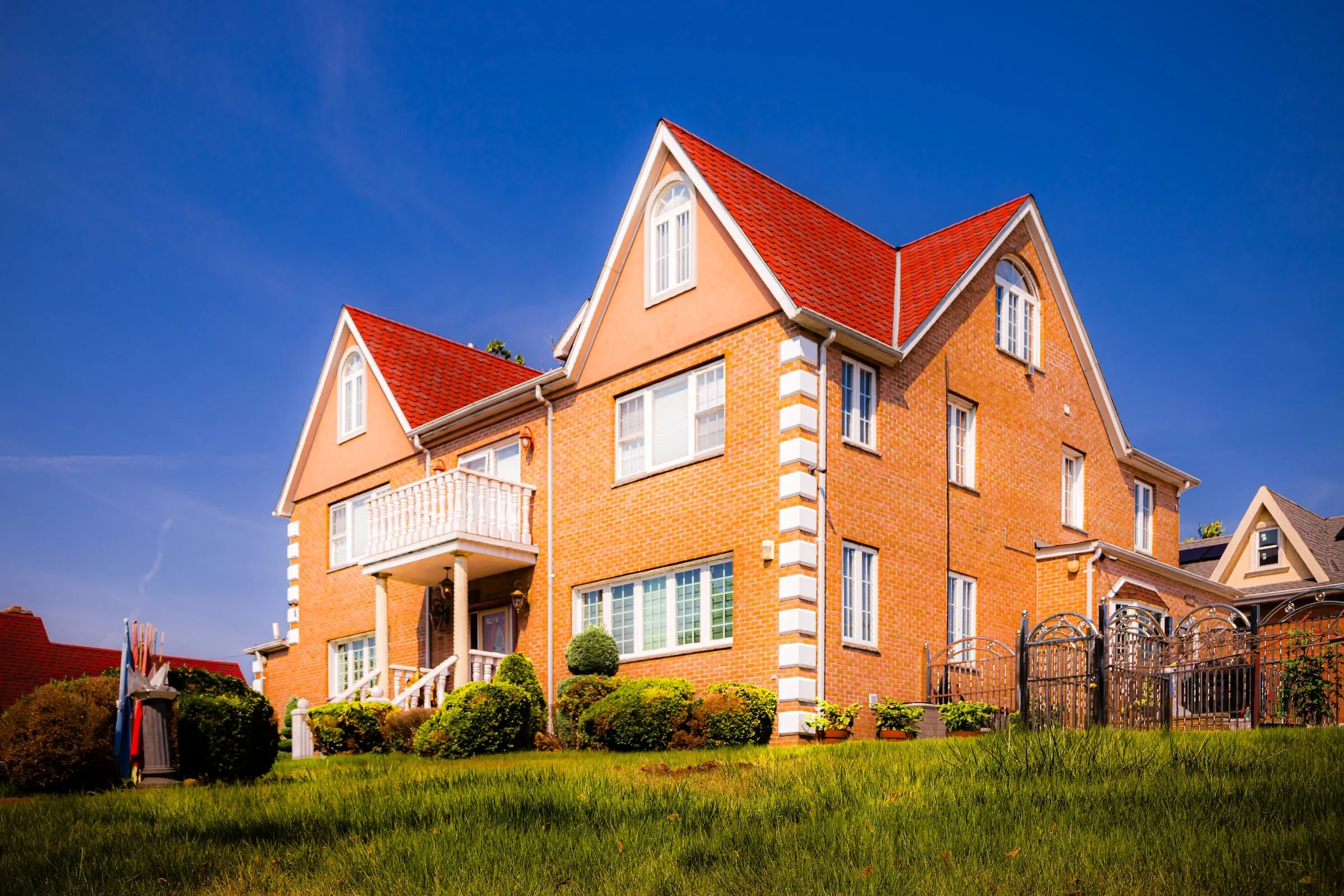
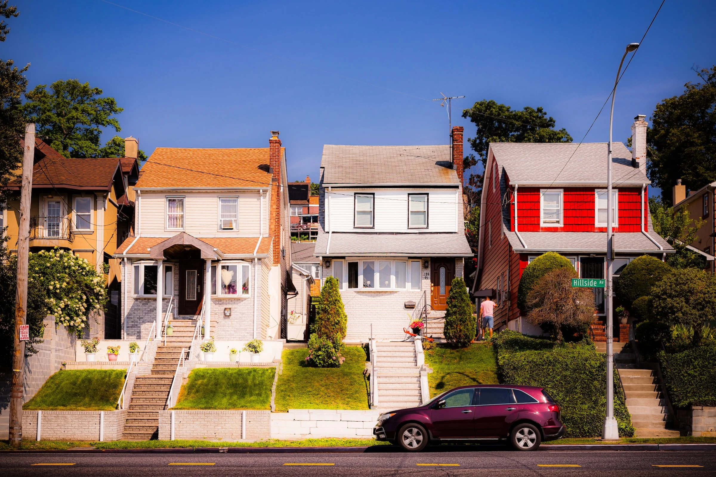
The Vertical Landscape: I sought to capture the "interest" created by the shifting terrain. In “Across Hillside,” the dramatic upward slope of the residential lots emphasizes the neighborhood's "hilltop" character, with homes perched prominently above the street level. This elevation allowed for unique low-angle shots that highlight the height and grandeur of the local architecture.
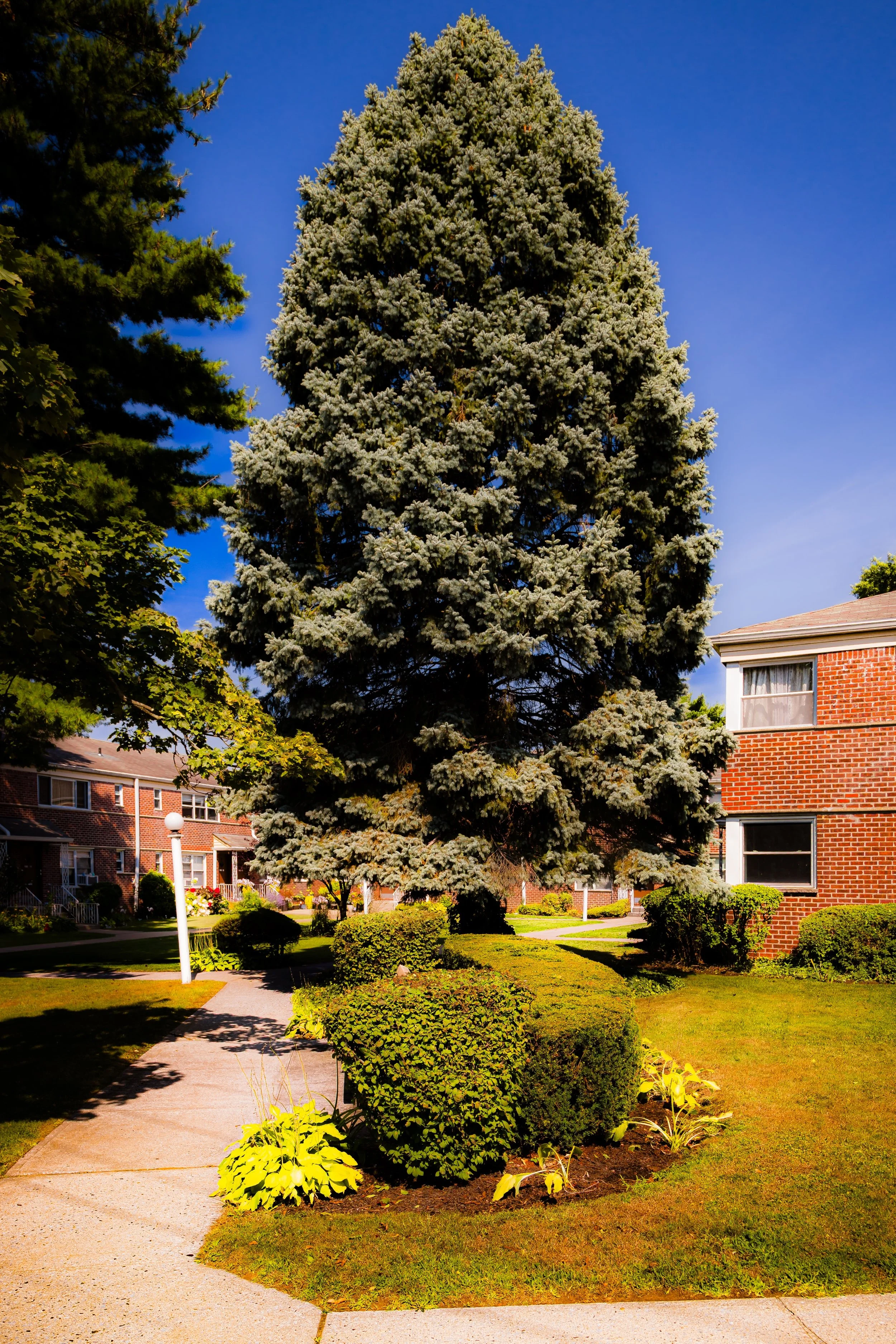
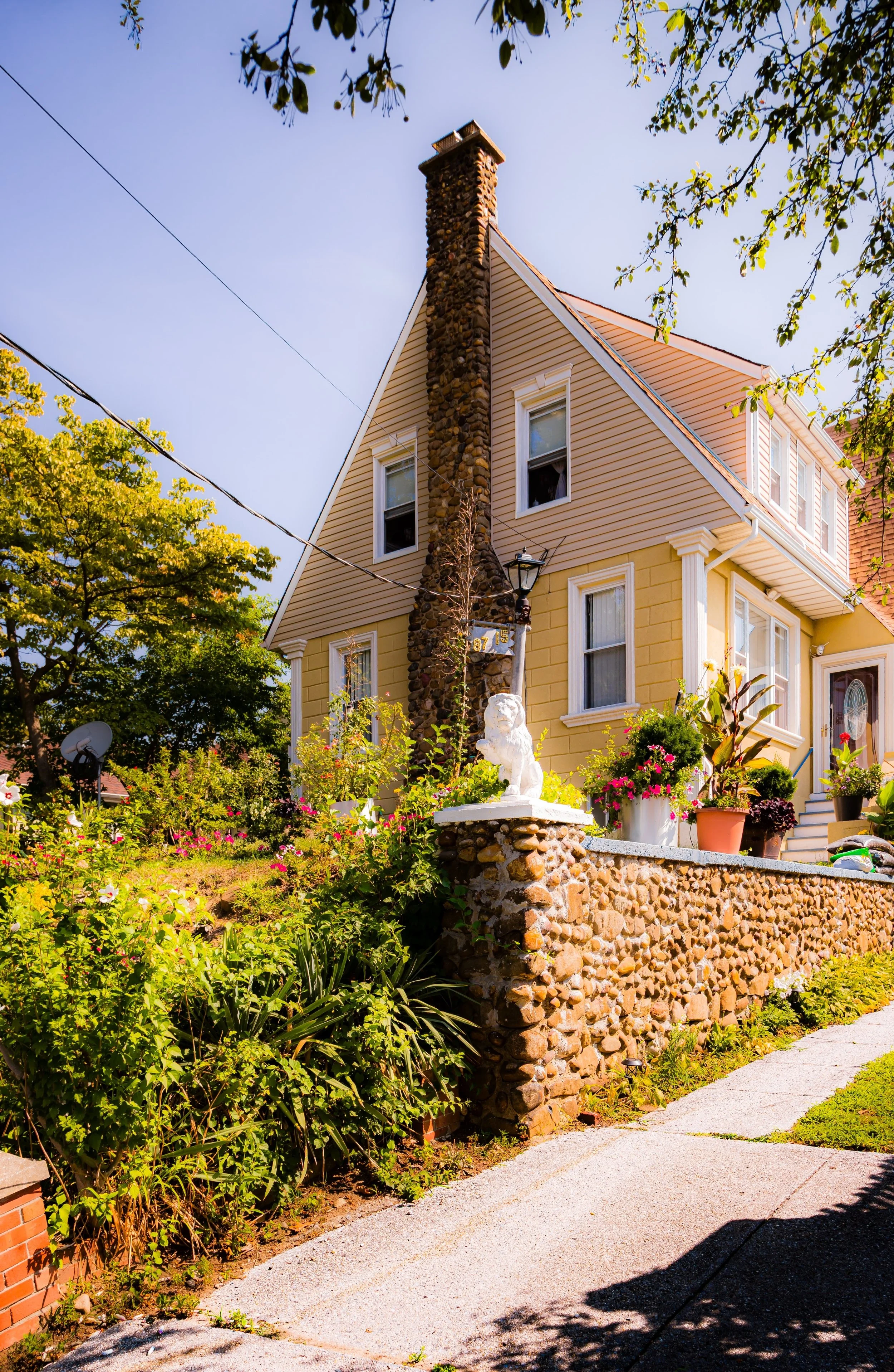
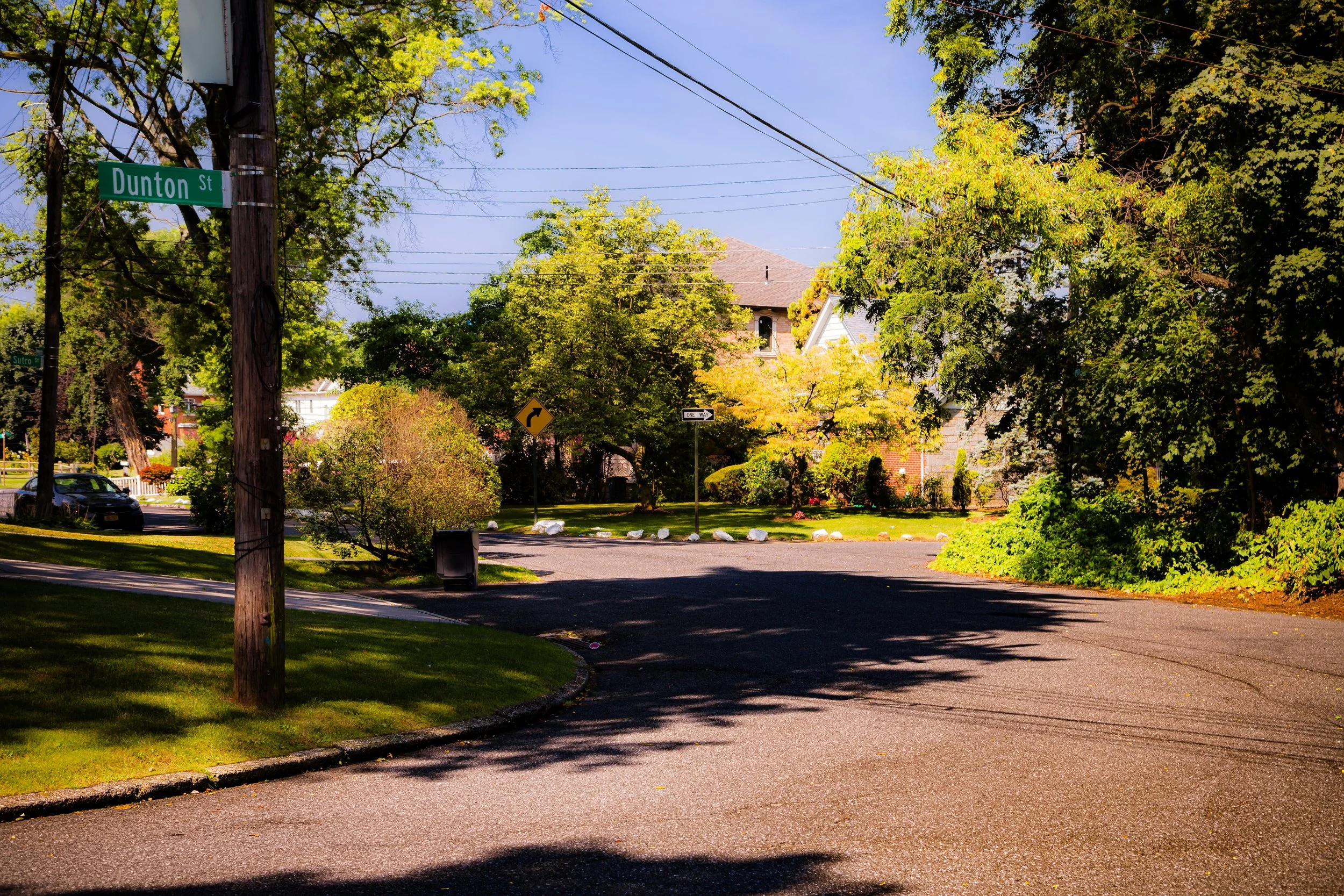
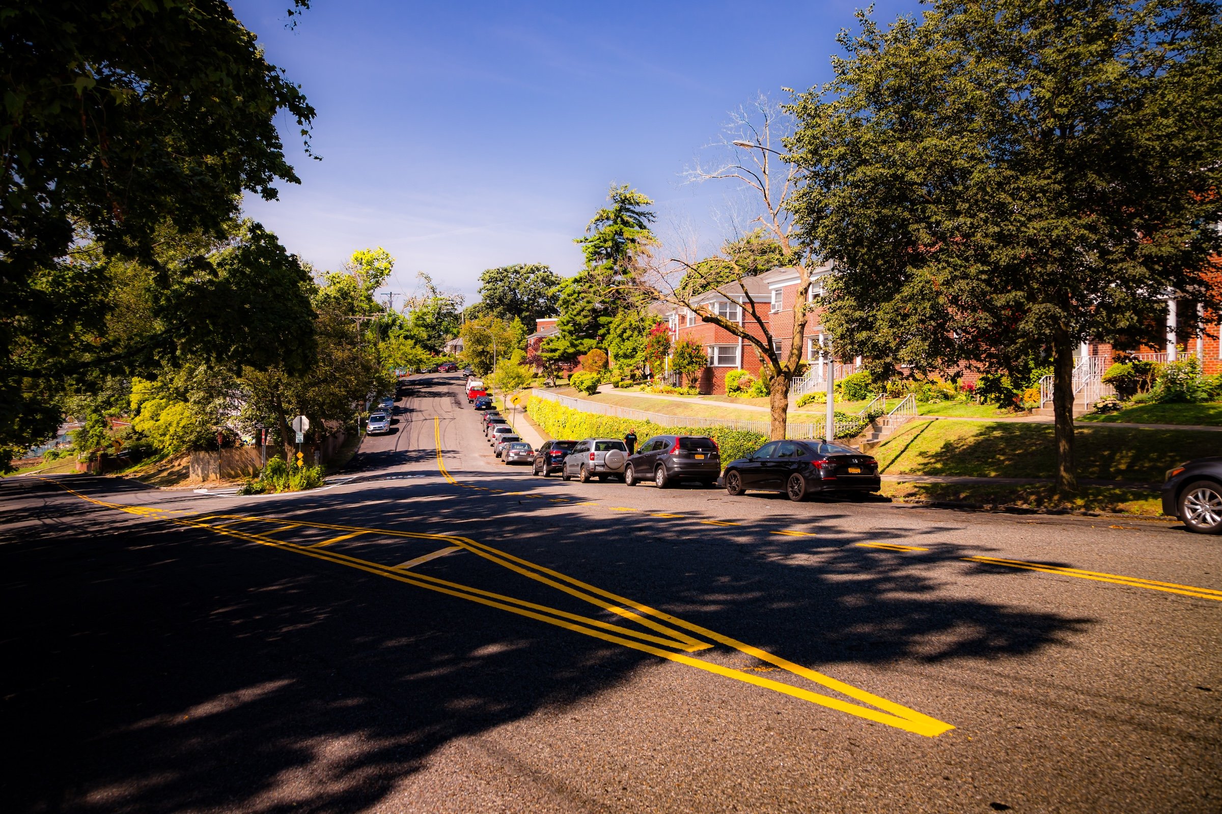
A Forest-Like Sanctuary: The neighborhood’s "spirit" is tied closely to its mature urban forest. I documented how the deep shadows of massive oaks and maples stretch across intersections like Dunton Street (see “Dunton At Epsom”), providing a natural, cooling screen that reinforces the area's secluded feel.
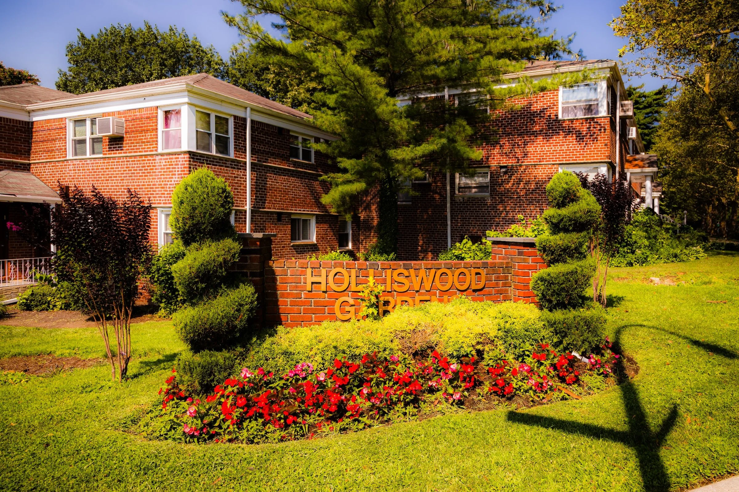
Architectural Diversity: I was particularly interested in the contrast between different housing styles found within blocks of each other. I documented the "Holliswood Gardens" brick complex (see “Holliswood Gardens”) as a communal anchor, contrasting it with the grand, red-roofed modern estates that dominate the higher ridges (see “Red Gables On The Hillside”). The brilliant 10:30 AM sunshine was essential for capturing the textures of these varied materials—from the classic brickwork to the crisp, white architectural accents.
Spirit and Legacy
Holliswood’s spirit lies in its elevation—geographically, architecturally, and communally. It embodies the 20th-century vision of suburban living within New York City: a neighborhood of trees and terraces, of neighbors who know one another, and of homes that harmonize with the land they stand on. Its wooded slopes, winding streets, and civic pride distinguish it as one of the few remaining places in the city where the ideal of the “urban garden suburb” remains fully intact.
Holliswood Field Notes
-
Field Note: August 5, 2023 | 10:12 AM
Conditions: 76°F | Humidity: 65%.
As the humidity began to drop, the visibility across the winding, hillside streets of Holliswood sharpened significantly. The mid-morning sun provided a golden saturation to the varied architectural textures of the neighborhood's manor-style homes.
Holliswood proved to be a remarkable "hidden highland" just north of the busy Hillside Avenue corridor. I was immediately struck by the silence of the forest-like streets; the change in elevation creates a physical and visual separation from the rest of the borough that is both challenging to walk and incredibly rewarding to photograph. The way the late-morning sun filters through the dense canopy onto the winding asphalt (see “Dunton At 197th”) gives the neighborhood a secluded, pastoral energy.
Other neighborhoods visited:
Across Hillside - Click To Purchase Print
Dunton At 197th - Click To Purchase Print
Holliswood Gardens - Click To Purchase Print

Red Gables On The Hillside - Click To Purchase Print

Dunton At Epsom - Click To Purchase Print
Use this custom Google map to explore where every neighborhood in all five boroughs of New York City is located.
The Five Boroughs
One of New York City’s unique qualities is its organization in to 5 boroughs: Manhattan, Brooklyn, Queens, The Bronx, and Staten Island. These boroughs are part pragmatic administrative districts, and part vestiges of the region’s past. Each borough is an entire county in New York State - in fact, Brooklyn is, officially, Kings County, while Staten Island is, officially Richmond County. But that’s not the whole story …
Initially, New York City was located on the southern tip of Manhattan (now the Financial District) that was once the Dutch colony of New Amsterdam. Across the East River, another city was rising: Brooklyn. In time, the city planners realized that unification between the rapidly rising cities would create commercial and industrial opportunities - through streamlined administration of the region.
So powerful was the pull of unification between New York and Brooklyn that three more counties were pulled into the unification: The Bronx, Queens, and Staten Island. And on January 1, 1898, the City of New York unified two cities and three counties into one Greater City of New York - containing the five boroughs we know today.
But because each borough developed differently and distinctly until unification, their neighborhoods likewise uniquely developed. Today, there are nearly 390 neighborhoods, each with their own histories, cultures, cuisines, and personalities - and each with residents who are fiercely proud of their corner of The Big Apple.


