FORT WADSWORTH
Staten Island
Geographic Setting
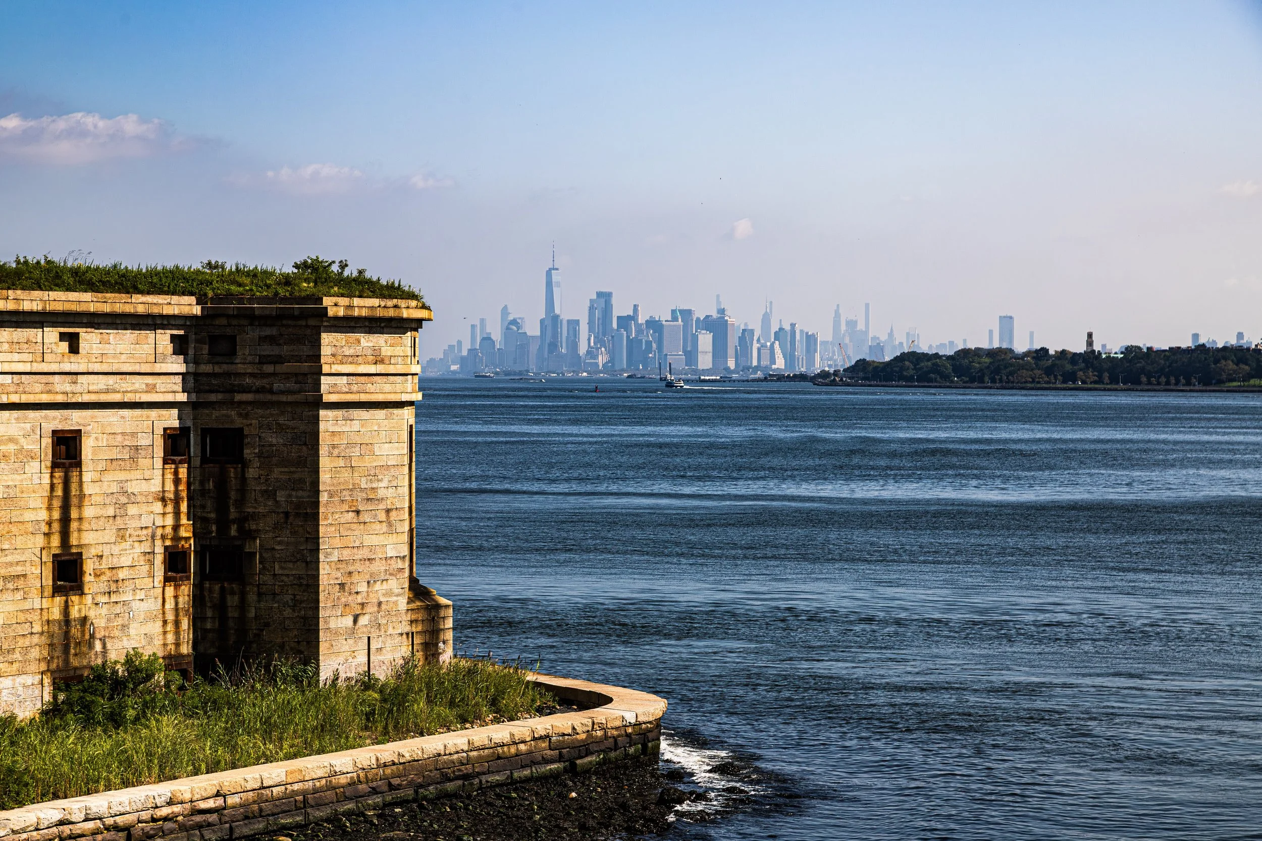
Situated at the southeastern tip of Staten Island where the Narrows connects the Upper and Lower New York Bays, Fort Wadsworth occupies one of the most strategic and scenic sites in New York City. The fort’s grounds extend along the steep coastal bluffs between Bay Street and Lily Pond Avenue to the west, and the Verrazzano-Narrows Bridge to the east, overlooking the narrow strait that has for centuries served as the maritime gateway to New York Harbor.
From its ramparts, the views encompass the Manhattan skyline, Brooklyn’s Shore Road, and the expanse of the Atlantic beyond the Verrazzano’s soaring towers. Beneath its modern layers of highway and bridge infrastructure, the landscape still bears the imprint of centuries of military architecture—stone bastions, brick casemates, and earthen ramparts that descend toward the water. Today, Fort Wadsworth forms part of the Gateway National Recreation Area, yet its terrain still resonates with the echoes of centuries of watchfulness, standing as both monument and guardian of the harbor it once defended.
Etymology
The name Fort Wadsworth honors Brigadier General James S. Wadsworth (1807–1864), a Union Army officer killed in the Battle of the Wilderness during the American Civil War. The designation was adopted in 1865, replacing earlier names such as Fort Richmond and Fort Tompkins, which had referred to separate but adjacent defensive works on the same site.
The area itself had been known since the colonial era as Signal Hill or Flagstaff Hill, reflecting its early function as a lookout and signal post for approaching ships. The succession of names—Signal Hill, Fort Richmond, Fort Wadsworth—charts the evolution of the site from coastal lookout to bastioned fortress, and finally to a unified military installation that would guard the Narrows for more than two centuries.
The Neighborhood
Origins through the 18th Century: Colonial Outpost and Revolutionary Stronghold
The strategic value of the Narrows was recognized almost as soon as Europeans began sailing into New York Harbor. By the mid-17th century, Dutch settlers established signal fires on Staten Island’s bluffs to warn of incoming vessels. When the English assumed control, they continued the practice, using Signal Hill as part of a rudimentary defense network.
During the American Revolution, British forces quickly seized the site, recognizing its commanding vantage over the harbor entrance. In 1776, the British established a fortified position here as part of their broader occupation of Staten Island and New York City. The Narrows became a major anchorage for the Royal Navy, and the bluffs were fortified with earthworks and cannon to protect the fleet.
After the war, the site returned to American hands but remained largely undeveloped until the early 19th century. The young republic, wary of foreign invasion after the War of 1812, launched an ambitious program of coastal fortification known as the Second System of national defense. The Staten Island bluffs were chosen for a major new stronghold to guard the harbor’s outer gate.
19th Century: Building the Great Fortress of the Narrows
Construction of permanent masonry fortifications began in 1808, with the erection of Fort Richmond near the waterline and Fort Tompkins on the higher ground directly above it. These twin bastions were part of a coordinated harbor defense system that included Fort Hamilton across the Narrows in Brooklyn. Their interlocking fields of fire could seal the harbor entrance against any hostile fleet.
By the 1840s, both forts were rebuilt and expanded under the Third System of Coastal Defense, using granite and brick casemates capable of mounting hundreds of heavy cannon. Fort Richmond—later incorporated into Fort Wadsworth—featured arched galleries, bombproof magazines, and tiered gun emplacements, while Fort Tompkins’s massive earth-covered walls housed troops and officers’ quarters.
In 1865, following the Civil War, the two forts and surrounding batteries were unified under the name Fort Wadsworth, in honor of General James Wadsworth. The installation became a permanent U.S. Army garrison and continued to evolve through the late 19th century as technology advanced. New gun batteries—Battery Weed, Battery Duane, and others—were added to the shoreline to accommodate modern artillery. The post grew into a small military village, complete with barracks, officer housing, a hospital, and parade grounds.
Throughout the century, Fort Wadsworth stood as a symbol of national vigilance, its towering walls visible to every ship entering the harbor—a silent statement of defense and deterrence.
Early 20th Century: Modernization and World Wars
At the dawn of the 20th century, Fort Wadsworth adapted to new forms of warfare. The era’s coastal defense strategy, known as the Endicott Program, introduced reinforced concrete gun batteries equipped with disappearing guns and searchlights. Battery Weed, completed in 1903, replaced much of the old masonry fort and became the centerpiece of the harbor’s outer defense. Its four massive 12-inch guns could hurl shells far into the Atlantic, while subterranean galleries housed ammunition and communications rooms.
During World War I, Fort Wadsworth served as both a defensive post and a mobilization site for troops and supplies. Its guns were manned by the U.S. Coast Artillery Corps, though the harbor never came under direct threat. In the interwar years, the fort continued to modernize, adding antiaircraft batteries and observation towers.
During World War II, Fort Wadsworth once again played a vital role in harbor defense. Radar stations, anti-aircraft emplacements, and anti-submarine nets across the Narrows turned the fort into a high-tech command post for protecting New York Harbor against potential enemy attack. Thousands of soldiers and sailors passed through its gates, and the post’s strategic importance remained unquestioned even as warfare began to shift from coastal artillery to aerial and naval supremacy.

Fort Wadsworth Video Coming Soon
Mid–Late 20th Century: Transition and Preservation
By the 1950s, advances in missile and naval technology rendered traditional harbor forts obsolete. Fort Wadsworth’s heavy guns were dismantled, and the site was repurposed as a training and administrative center. The U.S. Navy assumed control in 1979, using the installation as Naval Station New York and housing command offices, reserves, and support facilities. For more than a century and a half, the fort’s guns had never been fired in anger—a testament to deterrence and geography rather than combat.
In 1994, the Navy decommissioned the site, and Fort Wadsworth was transferred to the National Park Service as part of the Gateway National Recreation Area. Restoration efforts began immediately, preserving the 19th-century stone and brick structures as part of one of the most complete coastal defense complexes in the United States. Public access reopened in stages, allowing visitors to explore ramparts, tunnels, and gun batteries that had long been closed to civilians.
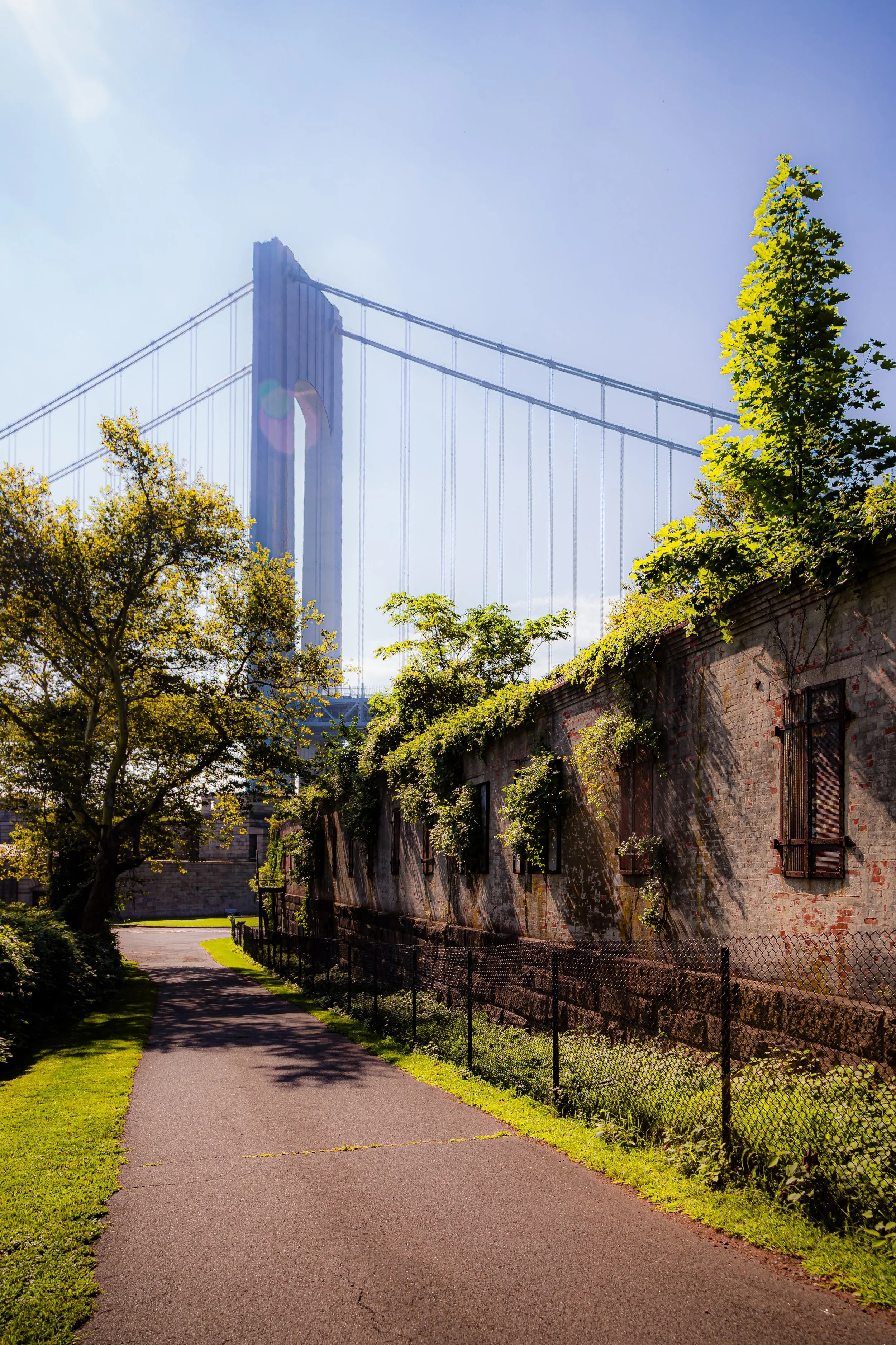
The construction of the Verrazzano-Narrows Bridge (1964) dramatically altered the site’s skyline but also linked its historical narrative to modern engineering achievement. The bridge’s anchorage rises directly beside the old fort walls, symbolically uniting two centuries of civic infrastructure—one built for defense, the other for connection.
21st Century: Heritage, Education, and the Edge of the Harbor
Today, Fort Wadsworth serves as both historic monument and public park, managed by the National Park Service as part of Gateway National Recreation Area’s Staten Island Unit. Visitors can walk through Battery Weed, explore the vaulted galleries of Fort Tompkins, and climb to lookout points offering unmatched views of the Narrows, the bridge, and the Manhattan skyline. The site’s trails and lawns connect to the broader Staten Island Greenbelt, while its beaches and picnic areas provide urban respite.
Interpretive programs and tours illuminate the fort’s layered history—from the colonial era through the Cold War—offering insight into New York’s maritime defenses and military evolution. Annual events such as Fleet Week open the harbor once again to naval ships, echoing centuries of maritime tradition. Restoration continues to stabilize the fort’s structures, balancing historic preservation with public accessibility.
Beyond its military story, Fort Wadsworth has become a site of contemplation—a place where the rhythms of history, architecture, and sea meet. The juxtaposition of the Verrazzano’s cables above and the granite arches below embodies the continuum of human ambition: from watchtowers to bridges, from isolation to connection.
Fort Wadsworth Photo Gallery
Spirit and Legacy
The spirit of Fort Wadsworth is one of endurance. For over 350 years, this bluff has watched over New York Harbor—first as signal post, then as fortress, later as monument. Its legacy is written in stone and sea, in the unbroken gaze that has faced every ship entering the Narrows since the city’s earliest days.
Here, the evolution of New York itself is visible: colonial outpost, industrial power, world city. The granite walls that once guarded against invasion now guard memory—reminders of the vigilance, ingenuity, and human labor that built them.

New York City
Use this custom Google map to explore where every neighborhood in all five boroughs of New York City is located.
The Five Boroughs
One of New York City’s unique qualities is its organization in to 5 boroughs: Manhattan, Brooklyn, Queens, The Bronx, and Staten Island. These boroughs are part pragmatic administrative districts, and part vestiges of the region’s past. Each borough is an entire county in New York State - in fact, Brooklyn is, officially, Kings County, while Staten Island is, officially Richmond County. But that’s not the whole story …
Initially, New York City was located on the southern tip of Manhattan (now the Financial District) that was once the Dutch colony of New Amsterdam. Across the East River, another city was rising: Brooklyn. In time, the city planners realized that unification between the rapidly rising cities would create commercial and industrial opportunities - through streamlined administration of the region.
So powerful was the pull of unification between New York and Brooklyn that three more counties were pulled into the unification: The Bronx, Queens, and Staten Island. And on January 1, 1898, the City of New York unified two cities and three counties into one Greater City of New York - containing the five boroughs we know today.
But because each borough developed differently and distinctly until unification, their neighborhoods likewise uniquely developed. Today, there are nearly 390 neighborhoods, each with their own histories, cultures, cuisines, and personalities - and each with residents who are fiercely proud of their corner of The Big Apple.


