CHARLESTON
Staten Island
Geographic Setting
Bounded by St. Luke’s Avenue to the northeast, the West Shore Expressway to the east, the Outerbridge Crossing to the south, and the Arthur Kill to the west, Charleston occupies the southwesternmost corner of Staten Island—a landscape where the rhythms of suburban life meet the tidewaters of the Kill and the great industrial arteries of the region. It is the island’s edge in both geography and history: a place of open skies, wide boulevards, and vast parcels of reclaimed land.
Charleston’s terrain is low and level, defined by salt meadows and woodlands that slope gently toward the Arthur Kill shoreline. To the east, the West Shore Expressway and Bloomingdale Road provide vital transportation links, while to the west, the view across the Kill stretches toward New Jersey’s refineries and ports. Within these bounds lies a mosaic of residential developments, commercial plazas, and preserved green space—including portions of the Clay Pit Ponds State Park Preserve and the ecologically rich Saw Mill Creek Marshes. Charleston today is at once Staten Island’s newest retail center and one of its oldest settled areas—a juxtaposition that defines its modern identity.
Etymology
The name Charleston emerged in the 1790s from Charles Kreischer, a German immigrant and brick manufacturer whose family established one of Staten Island’s most successful 19th-century industries. Originally known as Kreischerville, the area took its name from the Kreischer Brick Works, founded along Arthur Kill Road near the waterfront in 1854. For decades, the Kreischers’ distinctive yellow bricks—made from Staten Island clay—were shipped across the harbor and used in buildings throughout New York City.
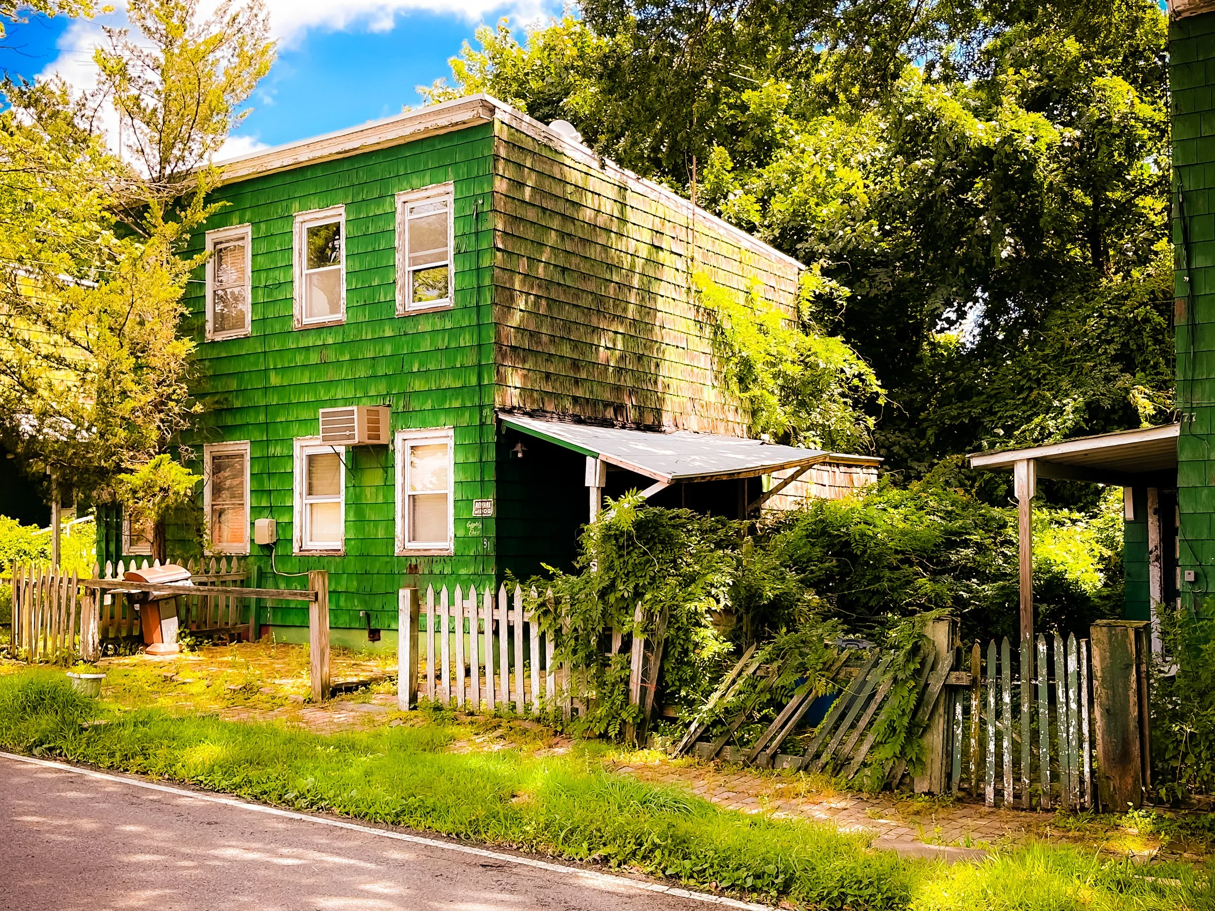
Following World War I, anti-German sentiment led to the renaming of Kreischerville to Charleston—a nod both to the original “Charles” and to the cultural shift of the early 20th century. The new name preserved the founder’s legacy while adopting a more neutral, Americanized identity. To this day, the Kreischer Mansion, a grand Victorian residence built by Balthasar Kreischer for his son, stands on Arthur Kill Road as one of Staten Island’s most hauntingly beautiful landmarks—a relic of industrial ambition and family tragedy amid a transformed landscape.
The Neighborhood
Origins through the 19th Century
Charleston’s history is among Staten Island’s oldest. The area was first inhabited by the Lenape, who fished and hunted along the Arthur Kill and used the freshwater streams that coursed through the land. In the 17th century, Dutch settlers claimed tracts of this fertile terrain, later joined by English farmers who established homesteads linked by rudimentary dirt lanes—predecessors of today’s Bloomingdale and Arthur Kill Roads.
By the early 1800s, Charleston had become a quiet rural community of farms and clay pits. Its abundant clay deposits, located near the shoreline, gave rise to a thriving brickmaking industry. The arrival of Balthasar Kreischer and his sons in the 1850s transformed the hamlet into a company town. The Kreischer Brick Works employed hundreds of laborers—many of them German and Irish immigrants—and the family built worker housing, a company store, and a stately mansion overlooking the Arthur Kill. The bricks fired in Charleston’s kilns helped build the very infrastructure of a growing New York.
During this period, the area also developed a small port, with barges and schooners loading bricks for shipment across the harbor. The community was close-knit, centered on the factory and the small churches that rose nearby. By the late 19th century, Charleston had become a recognizable settlement on Staten Island maps—a pocket of industry surrounded by open farmland and forest.
Early 20th Century: Industry and Isolation
The decline of the Kreischer Brick Works in the early 20th century marked a turning point. As industrial production consolidated elsewhere and demand shifted, the factory closed in 1927, and the surrounding area fell into relative quiet. Charleston reverted to a semi-rural outpost—a landscape of abandoned kilns, scattered houses, and overgrown clay pits slowly filling with water.
During the interwar years, small farms, boatyards, and junkyards dotted the area. The opening of the Outerbridge Crossing (1928) brought improved access, linking Staten Island to New Jersey and setting the stage for future development. Yet for decades afterward, Charleston remained isolated—its remoteness preserved by the wetlands and the absence of major transit infrastructure. The Kreischer Mansion, still occupied by descendants of the family, stood as a lone reminder of the area’s industrious past, while the rest of the land awaited rediscovery.
Charleston Video Coming Soon
Mid–Late 20th Century: Transition and Transformation
Charleston’s modern transformation began after World War II, when Staten Island’s southern and western reaches entered the suburban era. The construction of the West Shore Expressway (1960s) opened the area to residential and commercial development, though progress came slowly compared to other borough neighborhoods. The neighborhood’s isolation and flood-prone lands limited dense construction, preserving large tracts of open space well into the 1980s.
By the late 20th century, however, the city and state recognized Charleston’s potential as a site for both economic development and environmental conservation. The establishment of the Clay Pit Ponds State Park Preserve (1977) protected over 260 acres of rare pine barrens, ponds, and sand dunes—an ecosystem unique within New York City. This preserve, stretching along Bloomingdale Road and Sharrotts Road, became a sanctuary for wildlife and a beloved retreat for hikers, equestrians, and naturalists.
Meanwhile, on the former industrial lands near Arthur Kill Road, plans emerged for modern retail and commercial complexes that would bring new life to the area. By the century’s end, Charleston had begun its evolution from forgotten hamlet to emerging regional hub.
21st Century: The New Frontier of Staten Island
In the 21st century, Charleston has undergone one of Staten Island’s most striking renaissances. Once largely rural, it is now a nexus of commerce, recreation, and environmental restoration. The Bricktown Centre at Charleston, opened in 2007 and later expanded, introduced national retailers, restaurants, and a multiplex cinema, drawing visitors from across the island. New housing developments, including senior residences and planned townhome communities, have filled long-vacant lots, while wide, landscaped roads and modern infrastructure have reshaped the once-remote district into a model of suburban renewal.
At the same time, Charleston remains defined by its green expanse. The nearby Clay Pit Ponds Preserve, Saw Mill Creek wetlands, and the emerging Freshkills Park to the north form a vast environmental corridor that positions the neighborhood at the heart of Staten Island’s ecological rebirth. Along the Arthur Kill waterfront, proposals for greenways and observation piers aim to reconnect residents with the water that once sustained the community’s economy. The Kreischer Mansion, restored and occasionally opened for cultural events, serves as a poignant reminder of Charleston’s roots in craft, labor, and enterprise.
Charleston Photo Gallery
Spirit and Legacy
Charleston’s spirit is one of reinvention grounded in memory. It has moved through every phase of Staten Island’s story—from rural farmland to industrial village, from isolation to rebirth—without losing its sense of place. Its very name encapsulates that continuity: honoring the Kreischer family while embracing a broader civic identity.
For residents and visitors alike, Charleston today represents the meeting point of past and future. Its restored wetlands and preserved woodlands echo the island’s preindustrial landscape, while its modern plazas and expressways symbolize forward motion. The chimneys of the long-vanished brickworks may no longer rise over the Arthur Kill, but their legacy endures in every home and building that bears their mark.
New York City
Use this custom Google map to explore where every neighborhood in all five boroughs of New York City is located.
The Five Boroughs
One of New York City’s unique qualities is its organization in to 5 boroughs: Manhattan, Brooklyn, Queens, The Bronx, and Staten Island. These boroughs are part pragmatic administrative districts, and part vestiges of the region’s past. Each borough is an entire county in New York State - in fact, Brooklyn is, officially, Kings County, while Staten Island is, officially Richmond County. But that’s not the whole story …
Initially, New York City was located on the southern tip of Manhattan (now the Financial District) that was once the Dutch colony of New Amsterdam. Across the East River, another city was rising: Brooklyn. In time, the city planners realized that unification between the rapidly rising cities would create commercial and industrial opportunities - through streamlined administration of the region.
So powerful was the pull of unification between New York and Brooklyn that three more counties were pulled into the unification: The Bronx, Queens, and Staten Island. And on January 1, 1898, the City of New York unified two cities and three counties into one Greater City of New York - containing the five boroughs we know today.
But because each borough developed differently and distinctly until unification, their neighborhoods likewise uniquely developed. Today, there are nearly 390 neighborhoods, each with their own histories, cultures, cuisines, and personalities - and each with residents who are fiercely proud of their corner of The Big Apple.


