CARROLL GARDENS
Brooklyn
Geographic Setting
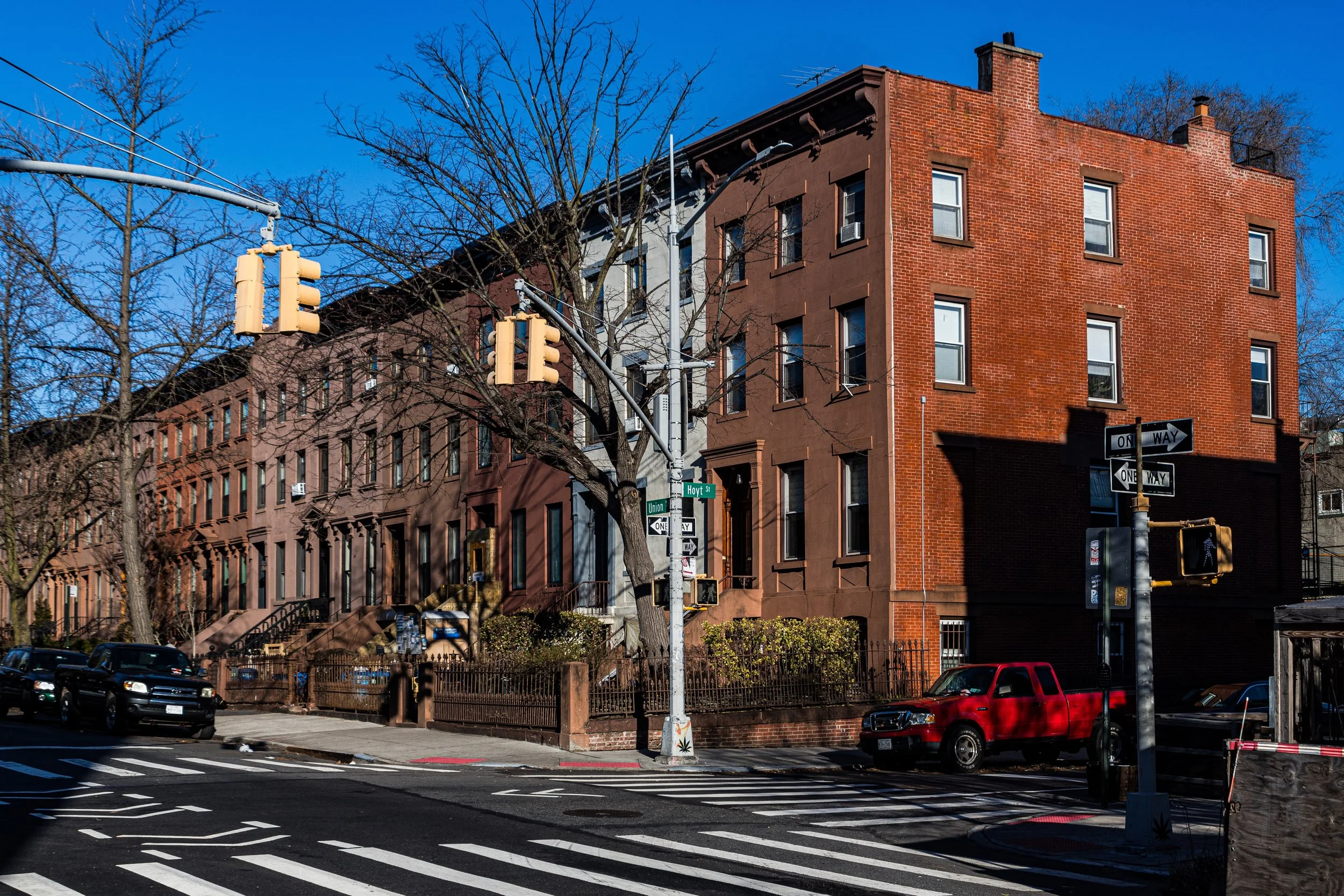
Bounded, going clockwise, by the Brooklyn–Queens Expressway (BQE) north to Degraw Street, east to Court Street, north to Baltic Street, east to Hoyt Street, south to 5th Street, west to Smith Street, south to the Gowanus Expressway, and then northwest to the BQE, Carroll Gardens sits at the juncture between Cobble Hill, Red Hook, and the industrial flats of Gowanus. It is one of Brooklyn’s most cherished brownstone neighborhoods—celebrated for its deep front gardens, leafy streets, and a uniquely self-contained village character that blends Old World warmth with modern sophistication.
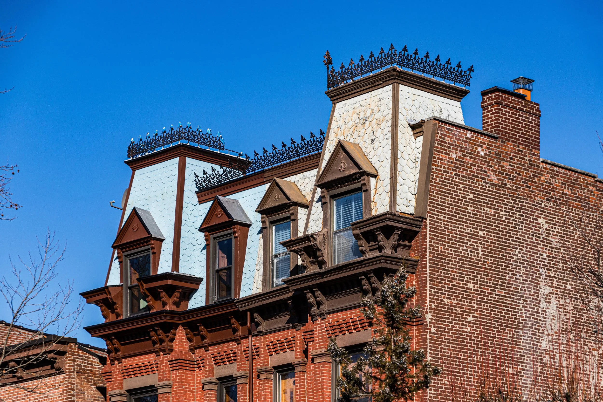
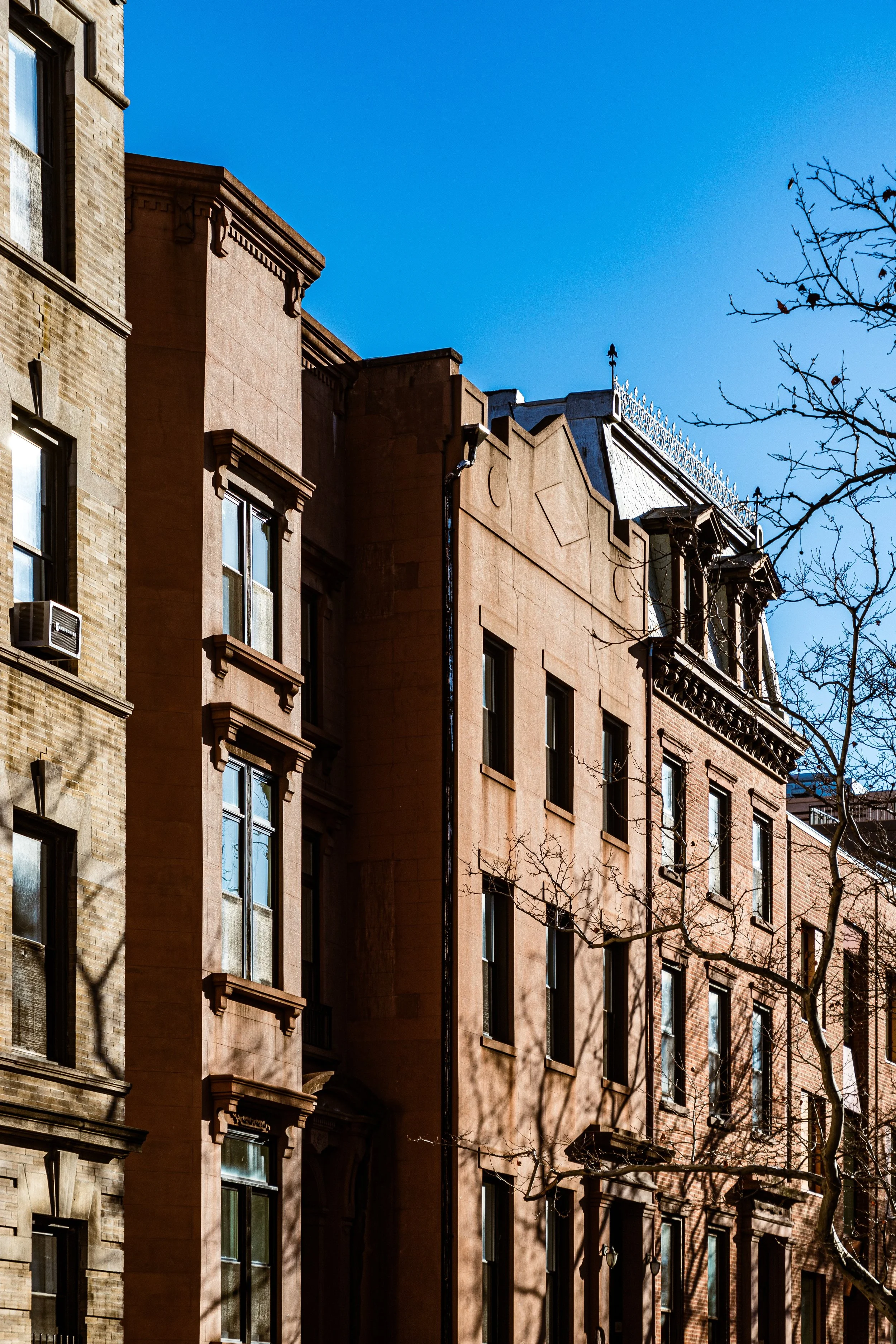
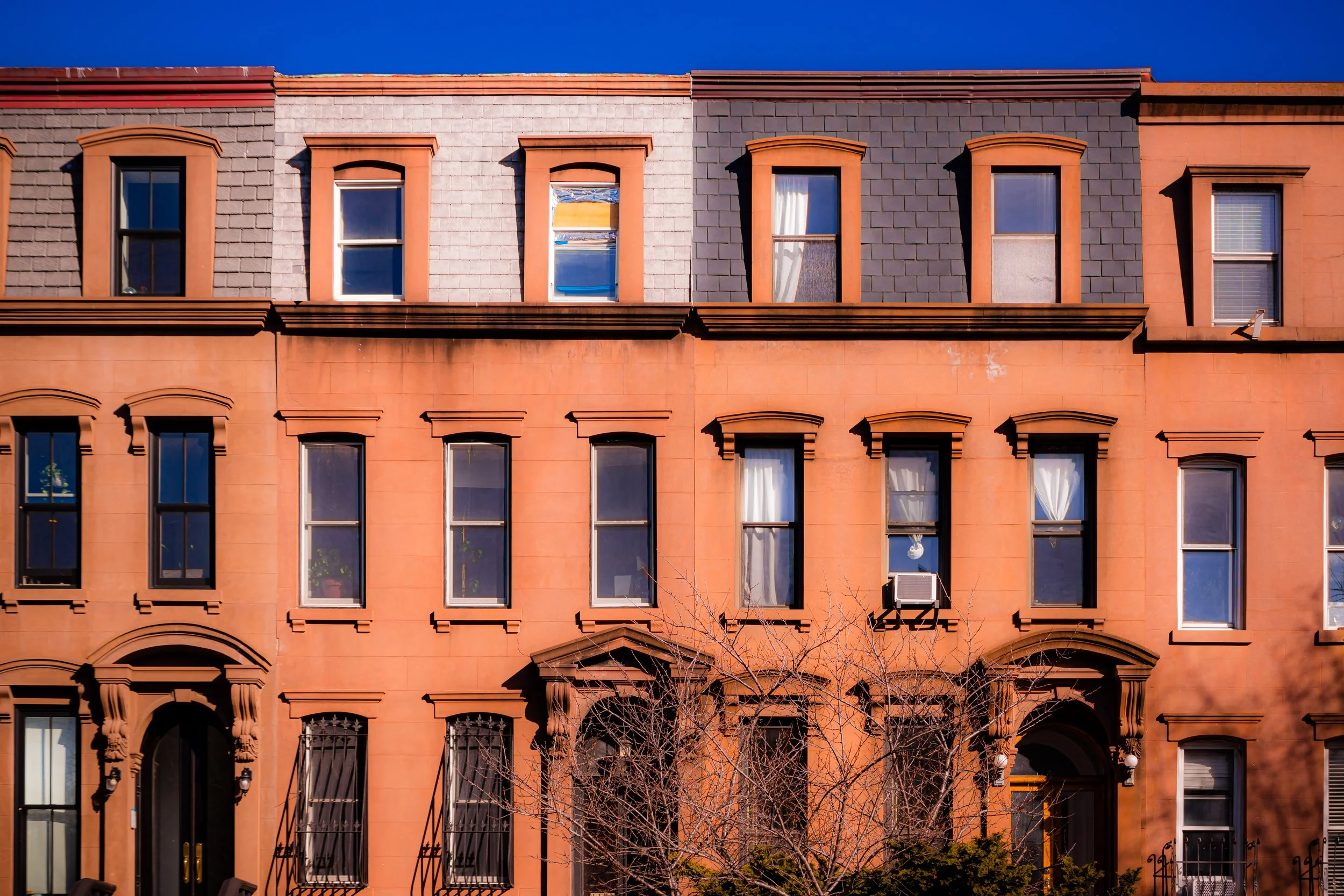
Unlike the tight, stoop-to-sidewalk pattern typical of nearby Cobble Hill, Carroll Gardens breathes. Its defining feature—the deep, landscaped front yards from which it takes its name—creates a gracious rhythm of space and light rarely found in New York’s brownstone districts. These gardens, typically extending 33 to 45 feet from stoop to curb, are bordered by wrought-iron fences and shaded by linden, maple, and plane trees. Along President, Carroll, and Second Streets, rows of brownstones and Italianate townhouses form one of the most photogenic streetscapes in the city.
Etymology and Origins
Carroll Gardens derives its name from Charles Carroll of Carrollton, a Maryland statesman and the only Catholic signer of the Declaration of Independence. The name was applied in the 1850s when developers sought to lend patriotic distinction to a new residential enclave emerging south of Atlantic Avenue. The “Gardens” portion was literal: the neighborhood’s unusual front setbacks were mandated by a visionary 1846 street plan drafted by surveyor Richard Butts, who required 33-foot-deep yards for houses built between Henry and Smith Streets—a decision that gave Carroll Gardens its defining grace and enduring appeal.
Before that, the area had been part of the old South Brooklyn settlement, its low, marshy terrain gradually filled and developed through the 19th century. Italian immigrants, longshoremen, and small tradesmen transformed it into a thriving enclave by the late 1800s, while the neighboring Gowanus Canal provided the industrial lifeblood—and, later, the environmental challenge—that shaped the district’s destiny.
The Neighborhood
19th Century: The Making of a Garden Neighborhood
Carroll Gardens’ development began in earnest in the 1840s–1860s, as the shipping boom along the Brooklyn waterfront spurred housing demand for dockworkers and merchants. The Butts Plan established the grid and setbacks that distinguished this district from its denser neighbors. Greek Revival and Italianate brownstones soon lined the streets—Carroll, President, Second, and Third—each built with high stoops, ironwork, and the now-famous front gardens planted with lilac, rose, and hydrangea.
Court and Smith Streets emerged as twin commercial corridors. Court Street, anchored by churches such as St. Mary Star of the Sea (1853) and later St. Agnes (1878), served the neighborhood’s spiritual and civic needs. Smith Street thrived with butcher shops, grocers, tailors, and bakeries catering to working families. The area’s proximity to Red Hook’s docks and the Brooklyn Navy Yard ensured a steady flow of laborers and artisans, many of them Irish and, later, Italian immigrants.
By the 1880s, the district was largely built out—a mix of elegant rowhouses west of Smith Street and more modest tenements to the east toward Hoyt and Bond Streets. The completion of the Gowanus Canal (1869), though designed to enhance commerce, introduced an industrial frontier just beyond Carroll Gardens’ tidy rows, foreshadowing the environmental contradictions that would later define the area.
Early–Mid 20th Century: The Italian Enclave
The early 1900s cemented Carroll Gardens’ identity as a tight-knit Italian-American community. Families from southern Italy—especially Sicily and Naples—settled around Carroll, President, and Union Streets, establishing bakeries, social clubs, and religious societies. The aroma of espresso, tomato sauce, and fresh bread filled the air. The Sacred Hearts–St. Stephen Church (1882, rebuilt 1941) on Summit Street became the neighborhood’s spiritual center, while feast days like that of Our Lady of Sorrows and Santa Maria Addolorata brought processions, brass bands, and fireworks to the narrow streets each summer.
During these decades, Carroll Gardens was more than an address—it was a village. Residents shopped locally, attended parish schools, and socialized on stoops and sidewalks. Court Street became synonymous with Italian culture in Brooklyn, lined with pork stores, pastry shops, and tailor shops. At the same time, however, urban pressures loomed: overcrowding east of Smith Street, pollution from the Gowanus Canal, and a gradual decline in dockside industry.
By the 1950s–1960s, city planning projects began to reshape the neighborhood’s edges. The construction of the Brooklyn–Queens Expressway (BQE) and Gowanus Expressway severed Carroll Gardens from Cobble Hill and Red Hook, enclosing it within highway walls that paradoxically protected its quiet core while isolating it from the rest of the borough.
Carroll Gardens Photographic Video
Late 20th Century: Preservation and Renaissance
In the 1970s–1980s, as much of South Brooklyn faced disinvestment, Carroll Gardens retained a surprising stability. Many Italian-American families remained, maintaining their brownstones with care. Simultaneously, a new wave of residents—artists, professionals, and preservationists—recognized the neighborhood’s architectural beauty and sense of community.
The area’s deep gardens, human scale, and proximity to Manhattan made it an early beneficiary of the brownstone revival sweeping Brooklyn. In 1973, portions of Carroll Gardens were included in the Cobble Hill Historic District, and later preservation efforts extended to safeguard additional blocks. While neighboring Red Hook and Gowanus suffered from industrial decline, Carroll Gardens’ tree-lined calm and cohesive identity made it a haven for families seeking urban charm without chaos.
By the 1990s, new cafés and boutiques appeared along Smith Street, transforming it into a dining destination while preserving its essential rhythm of local storefronts. The neighborhood’s demographic balance began to shift, yet many of its Italian institutions—like Esposito & Sons Pork Store, Court Pastry Shop, and Monteleone’s Bakery—continued to anchor its cultural identity.
21st Century: Balancing Heritage and Change
Today, Carroll Gardens is one of Brooklyn’s most coveted residential neighborhoods—a rare enclave that has managed to balance preservation with evolution. Brownstones meticulously restored to 19th-century splendor stand beside newly designed townhouses that echo the district’s proportions and materials. Court Street’s Italian grocers share the block with French cafés, yoga studios, and bookstores; Smith Street, once a workingman’s avenue, has become synonymous with Brooklyn’s culinary renaissance.
Yet the neighborhood’s soul endures. The deep front gardens still bloom each spring; neighbors greet each other from stoops; and community life remains anchored in parishes, schools, and small businesses passed down through generations. At its southern edge, the long-debated Gowanus rezoning and canal cleanup have renewed conversations about environmental justice and historic preservation—issues Carroll Gardens has long embodied.
Amid its prosperity, residents continue to guard the qualities that make the neighborhood unique: walkability, intimacy, and a reverence for continuity. The balance between past and present here is not accidental—it is cultivated, like the gardens that line its streets.
Carroll Gardens Photo Gallery
Spirit and Legacy
Carroll Gardens’ legacy is one of urban grace born from design and devotion. From Richard Butts’s visionary 1840s plan to the Italian-American stoop culture that gave the neighborhood its warmth, it represents a harmony between architecture and community rare in the modern city. It is both a physical and social garden—a place where heritage, neighborliness, and the pleasures of daily life flourish in equal measure.
New York City
Use this custom Google map to explore where every neighborhood in all five boroughs of New York City is located.
The Five Boroughs
One of New York City’s unique qualities is its organization in to 5 boroughs: Manhattan, Brooklyn, Queens, The Bronx, and Staten Island. These boroughs are part pragmatic administrative districts, and part vestiges of the region’s past. Each borough is an entire county in New York State - in fact, Brooklyn is, officially, Kings County, while Staten Island is, officially Richmond County. But that’s not the whole story …
Initially, New York City was located on the southern tip of Manhattan (now the Financial District) that was once the Dutch colony of New Amsterdam. Across the East River, another city was rising: Brooklyn. In time, the city planners realized that unification between the rapidly rising cities would create commercial and industrial opportunities - through streamlined administration of the region.
So powerful was the pull of unification between New York and Brooklyn that three more counties were pulled into the unification: The Bronx, Queens, and Staten Island. And on January 1, 1898, the City of New York unified two cities and three counties into one Greater City of New York - containing the five boroughs we know today.
But because each borough developed differently and distinctly until unification, their neighborhoods likewise uniquely developed. Today, there are nearly 390 neighborhoods, each with their own histories, cultures, cuisines, and personalities - and each with residents who are fiercely proud of their corner of The Big Apple.


