HUDSON HEIGHTS
Manhattan
Geographic Setting
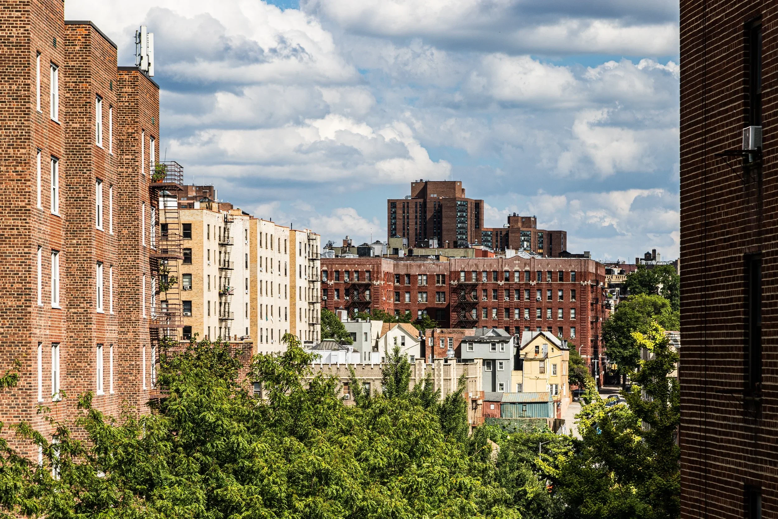
Perched high above the Hudson River on the steep bluffs of Upper Manhattan, Hudson Heights occupies one of New York’s most dramatic natural settings. It stretches from West 181st Street north to Dyckman Street, and from Broadway west to the Hudson River, encompassing the highest natural elevations on the island. The neighborhood forms the western half of Washington Heights, distinguished by its commanding views, leafy streets, and graceful prewar architecture.
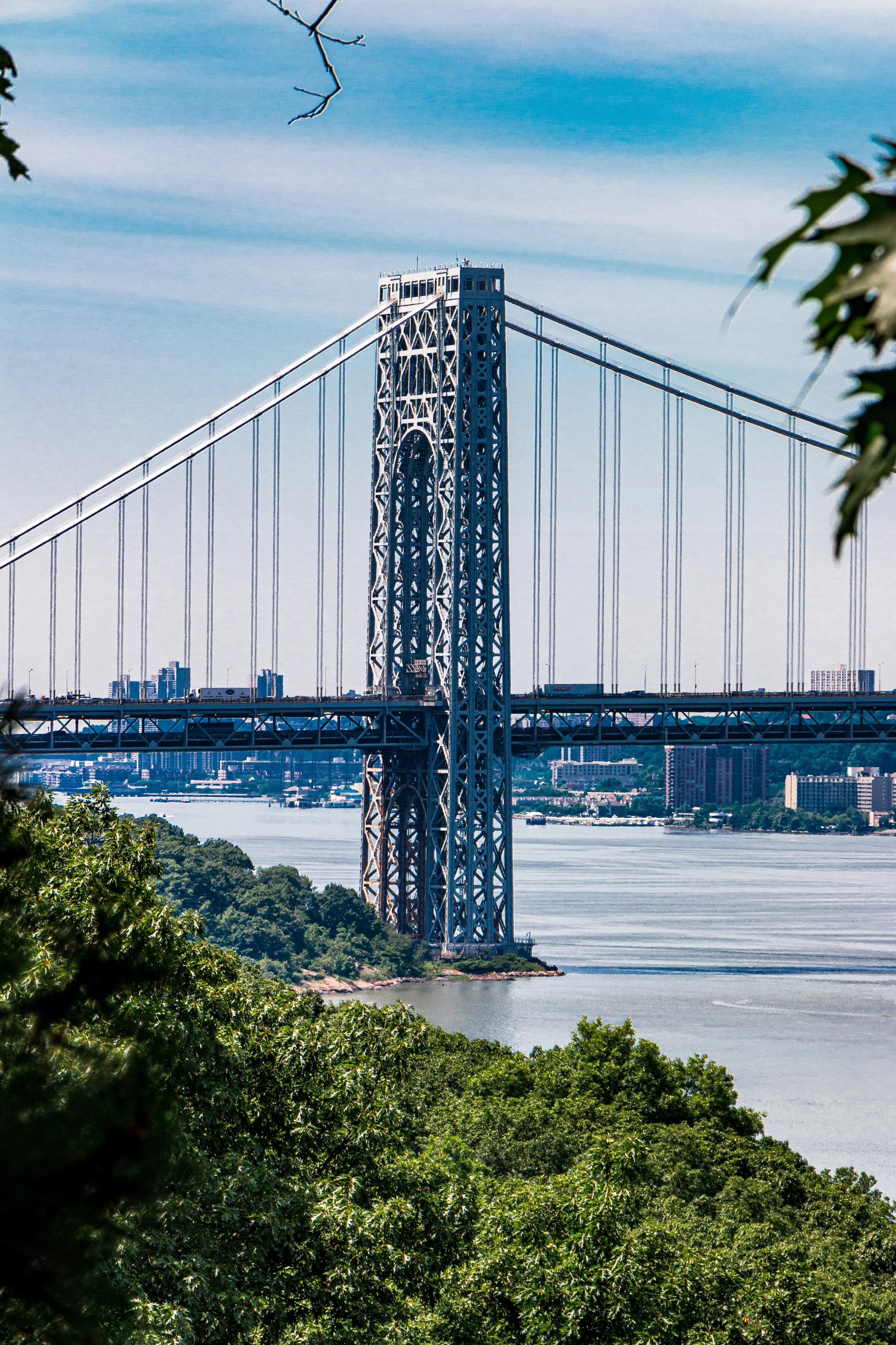
To the west, the Hudson River Greenway and Fort Washington Park trace the shoreline below the cliffs, while Bennett Avenue, Pinehurst Avenue, and Fort Washington Avenue wind along the ridge above. The George Washington Bridge, spanning the river at 181st Street, dominates the southern vista, its steel towers framing sunsets over the Palisades. Residential life centers around Cabrini Boulevard, 187th Street, and Bennett Park—the latter marking the highest natural point in Manhattan at 265 feet above sea level. The neighborhood’s geography, both scenic and secluded, has shaped its character as an urban village in the clouds.
Etymology and Origins
The name Hudson Heights is a relatively modern invention, coined in the late 20th century as residents sought to distinguish their leafy hilltop enclave from the broader Washington Heights below. Yet the area’s story is centuries older — a narrative of topography, conflict, and community stretching back to the 1600s.
For the Lenape, this ridge was sacred ground — part of a vast woodland known as Shorakapok, a term meaning “the edge of the waters.” Its bluffs and forests provided food, shelter, and spiritual continuity long before European arrival.
During the Revolutionary War, this very ground became the site of Fort Washington, a critical stronghold built by American forces in 1776 to defend the Hudson River against the British. Though the fort fell in November of that year after a fierce battle, its ruins — still visible within Fort Tryon Park — remain among the city’s most evocative Revolutionary relics. For over a century afterward, the land remained largely rural, dotted with estates such as Pinehurst and Cabrini Terrace, whose names linger in the local landscape.
The Neighborhood
19th Century: Estates Above the River
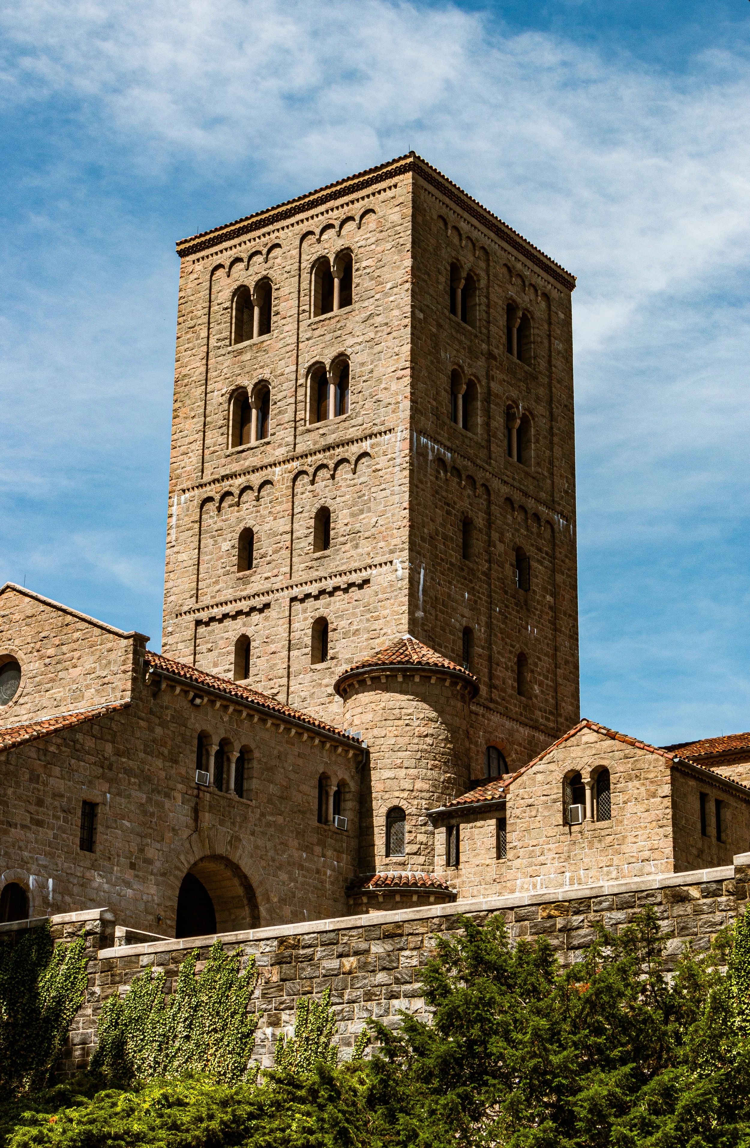
In the decades following the war, the Heights remained rural and largely untouched by development. Wealthy New Yorkers built summer estates along the ridge to escape downtown’s crowds and heat. The most notable transformation came in 1917, when philanthropist John D. Rockefeller Jr. purchased a vast swath of land along the western cliffs and donated it to the city for the creation of Fort Tryon Park. Designed by Frederick Law Olmsted Jr., the park’s winding paths, gardens, and overlooks preserved the natural grandeur of the landscape while offering New Yorkers a sanctuary in the sky.
Within the park, Rockefeller commissioned the Cloisters Museum, completed in 1938. Designed as a composite of medieval French monasteries and chapels, the museum — now part of the Metropolitan Museum of Art — houses one of the world’s foremost collections of medieval art and architecture. Its cloistered courtyards, stone arches, and hilltop vistas imbue Hudson Heights with a sense of time suspended, as though Manhattan itself were briefly translated to another century.
Early 20th Century: From Countryside to City Neighborhood
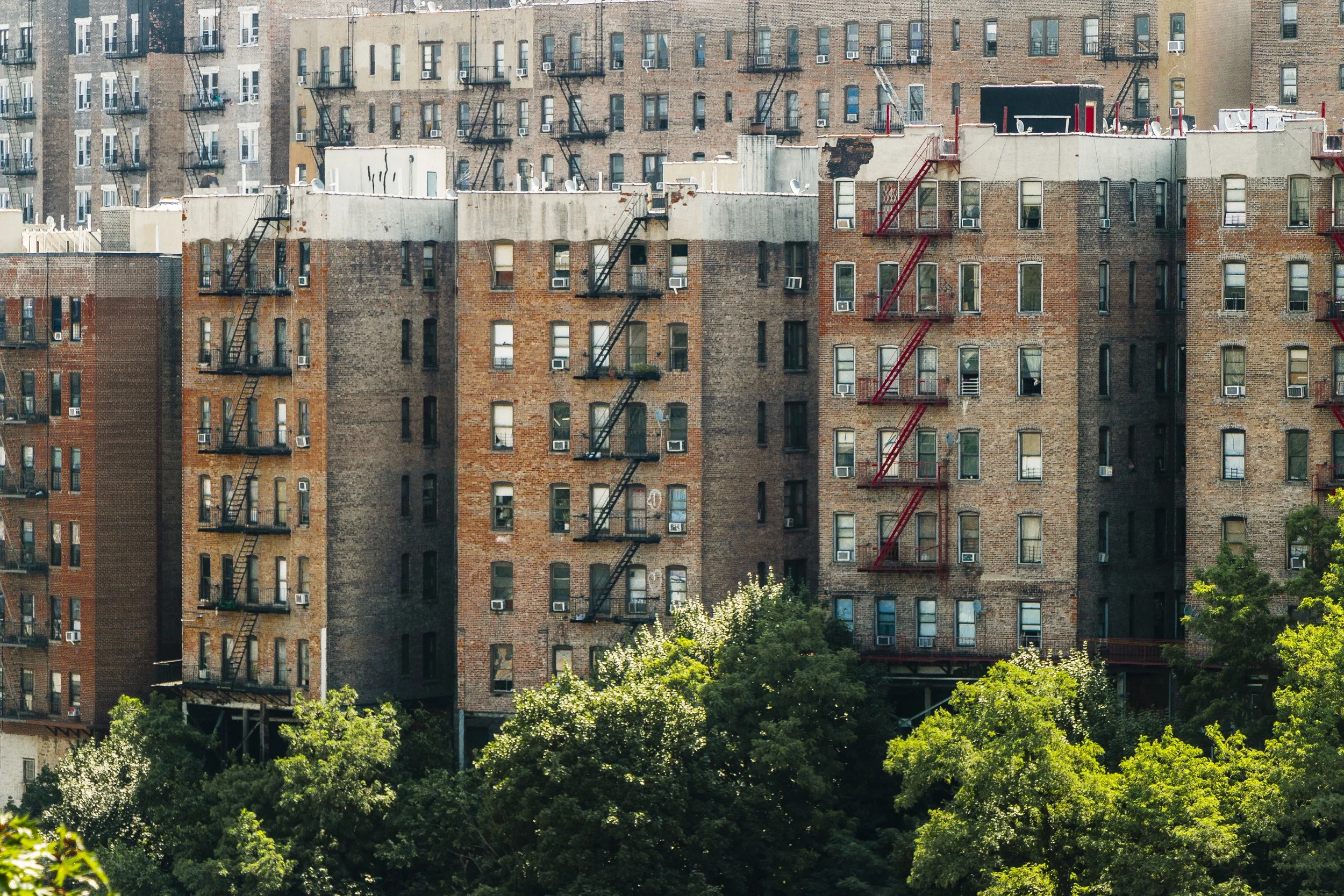
Residential development came late but swiftly. Between the 1920s and 1940s, as the IND Eighth Avenue Subway reached 190th Street, developers capitalized on the ridge’s views and air. Elegant Art Deco and Tudor Revival apartment buildings rose along Fort Washington Avenue, Cabrini Boulevard, and Pinehurst Avenue, their decorative details — sunbursts, mosaics, and curved corners — reflecting optimism between the wars.
These buildings were marvels of craftsmanship and community design. Spacious courtyards, rooftop terraces, and views of the river created an urban pastoralism unmatched elsewhere in Manhattan. Residents could step from tree-lined promenades directly into the wild beauty of Fort Tryon Park.
The area attracted a mix of middle-class professionals, artists, and immigrants — many of them German-Jewish refugees fleeing Nazism in the 1930s and 1940s. Known affectionately as “Frankfurt-on-the-Hudson,” Hudson Heights became a haven for thousands who rebuilt their lives here, bringing with them a culture of education, music, and café civility that remains part of the neighborhood’s ethos.
Mid-20th Century: Community and Continuity
Through the mid-20th century, Hudson Heights retained its peaceful, self-contained character even as the broader Washington Heights area faced demographic and economic shifts. The riverfront docks closed, and many businesses declined, but the hillside blocks remained stable, anchored by co-operative housing and strong local institutions.
The Cabrini Shrine, dedicated in 1955 on Fort Washington Avenue, became a spiritual and cultural landmark. Honoring Saint Frances Xavier Cabrini, the Italian-born missionary who served New York’s immigrant poor, the shrine — with its mosaics, marble, and golden reliquary — stands as a luminous testament to faith amid the city’s modern bustle.
The neighborhood’s gardens and courtyards gave it a calm domestic rhythm. Families gathered in Bennett Park, children sledded in winter, and the daily hum of life unfolded against the distant roar of traffic on the George Washington Bridge.
La
Hudson Heights Photographic Tour
Late 20th Century: Change and Preservation
The 1970s and 1980s brought turbulence to much of upper Manhattan, but Hudson Heights weathered the storm with relative resilience. Its cooperative buildings and engaged residents prevented widespread decline. Still, crime and economic hardship touched the area, and Fort Tryon Park fell into neglect.
By the 1990s, however, renewal had taken root. The Fort Tryon Park Trust and local volunteers restored gardens, pathways, and the park’s medieval-style stonework. Community efforts, paired with affordable housing initiatives, stabilized the neighborhood. The once-insular “Frankfurt-on-the-Hudson” community blended with growing Dominican-American and Latino populations, giving the area a new multicultural vibrancy.
21st Century: A Village in the Sky
In the new millennium, Hudson Heights has come into its own as one of Manhattan’s most livable enclaves — urban yet pastoral, connected yet quietly apart. The restoration of Fort Tryon Park, the renewed vitality of The Cloisters, and the continued preservation of prewar architecture have made it a model of sustainable urban continuity.
Rising real estate values have brought new residents — artists, families, professionals — drawn by the light, the greenery, and the rare sense of neighborhood identity. Local cafés, bookstores, and small restaurants now line 187th and 181st Streets, creating a convivial, village-like atmosphere.
Despite modernization, the area retains an ethos of calm reflection. The sound of church bells mingles with the rustle of leaves; the Hudson glows silver at sunset; and from Cabrini Boulevard, one can gaze westward across a panorama that remains unchanged since Hamilton’s time — cliffs, water, and horizon in perfect proportion.
Hudson Heights Photo Gallery
Architecture and Atmosphere
Architecturally, Hudson Heights is a showcase of Art Deco elegance and Tudor romanticism. Geometric ornamentation adorns the façades of its prewar co-ops; arched doorways, terra-cotta reliefs, and iron balconies lend warmth and personality. Courtyards bloom with gardens and fountains, while Cabrini Boulevard’s curved alignment frames cinematic views of the river.
The atmosphere is contemplative — more akin to a hillside European town than to the vertical density of Midtown. Morning joggers traverse Fort Tryon’s paths; schoolchildren pass medieval stone walls on their way to class; evenings bring couples strolling under elm canopies as the bridge lights shimmer overhead.
Spirit and Legacy
Hudson Heights is both a refuge and a revelation—a place where Manhattan’s natural grandeur and human history converge. Its story spans revolution, immigration, and rebirth, layered like its own terraced topography. From the Revolutionary fort to the émigré cafes, from postwar quietude to modern renewal, it has remained steadfastly itself: serene, scenic, and deeply rooted in continuity.
New York City
Use this custom Google map to explore where every neighborhood in all five boroughs of New York City is located.
The Five Boroughs
One of New York City’s unique qualities is its organization in to 5 boroughs: Manhattan, Brooklyn, Queens, The Bronx, and Staten Island. These boroughs are part pragmatic administrative districts, and part vestiges of the region’s past. Each borough is an entire county in New York State - in fact, Brooklyn is, officially, Kings County, while Staten Island is, officially Richmond County. But that’s not the whole story …
Initially, New York City was located on the southern tip of Manhattan (now the Financial District) that was once the Dutch colony of New Amsterdam. Across the East River, another city was rising: Brooklyn. In time, the city planners realized that unification between the rapidly rising cities would create commercial and industrial opportunities - through streamlined administration of the region.
So powerful was the pull of unification between New York and Brooklyn that three more counties were pulled into the unification: The Bronx, Queens, and Staten Island. And on January 1, 1898, the City of New York unified two cities and three counties into one Greater City of New York - containing the five boroughs we know today.
But because each borough developed differently and distinctly until unification, their neighborhoods likewise uniquely developed. Today, there are nearly 390 neighborhoods, each with their own histories, cultures, cuisines, and personalities - and each with residents who are fiercely proud of their corner of The Big Apple.


