
KIPS BAY
Manhattan
Neighborhood Profile
A balanced residential enclave on the East Side, Kips Bay is a functional and convenient neighborhood known for its mix of modern high-rise towers and quiet side streets. Home to a major medical corridor and the unique "super-block" architecture of Kips Bay Towers, it provides a grounded, professional atmosphere with easy access to the waterfront.
Geographic Setting
Framed by East 23rd Street to the south and East 34th Street to the north, and extending from Third Avenue to the East River, Kips Bay occupies a stretch of Midtown East that combines residential quiet with institutional gravity. Wedged between Murray Hill and Gramercy Park, and bordering the NYU Langone Medical Center and Bellevue Hospital to the east, the neighborhood lies at the hinge of the commercial city and the waterfront.
The grid slopes gently downward toward the river, where the FDR Drive and East River Greenway now trace the shoreline once indented by the actual bay for which the neighborhood is named. West of First Avenue, midblocks of prewar walk-ups, modest brownstones, and postwar brick co-ops blend with modern high-rises such as Kips Bay Towers, The Corinthian, and Waterside Plaza. Major arteries—Second Avenue, First Avenue, and East 30th Street—form the area’s primary conduits of movement, while the East River waterfront provides respite and light. Despite its proximity to Midtown, Kips Bay maintains a distinct sense of scale and rhythm—neither wholly residential nor institutional, but a layered coexistence of both.
Etymology and Origins
Kips Bay takes its name from Jacobus Hendrickson Kip, a Dutch settler, city magistrate, and member of one of New Amsterdam’s most prominent families. In 1655, Governor Peter Stuyvesant granted Kip 150 acres of land along a small inlet of the East River, then lined with salt marshes and orchards. The Kip’s Bay House, a brick homestead built the same year near present-day East 35th Street and Second Avenue, stood for nearly two centuries—a landmark of colonial endurance—before its demolition in 1851.
The “bay” itself—once a curved indentation of the East River between today’s 30th and 34th Streets—was gradually filled in during the 19th century to make room for shipyards and industrial wharves. Yet the name survived, a linguistic echo of the area’s pre-urban past. By the 1700s, “Kip’s Bay” referred not only to the inlet but also to the surrounding farmland, a peaceful shoreline where ferryboats and fishing vessels moored within sight of the growing city to the south.
The Neighborhood
18th Century: Revolution and the Rural Shoreline
The pastoral calm of colonial Kip’s Bay shattered on September 15, 1776, during the American Revolution, when British troops under General William Howe launched an amphibious assault here, landing thousands of redcoats on the East River shore. The Battle of Kip’s Bay became one of Washington’s most demoralizing defeats; panicked militia fled north toward Harlem, while British forces occupied Manhattan. The event was immortalized in letters describing “the men running as sheep before dogs.”
After independence, the area resumed its rural life. The Kip estate and neighboring farms grew hay, vegetables, and orchard fruit for Manhattan markets. The quiet shoreline hosted small quarries and breweries by century’s end, linked to the city by Boston Post Road and river ferries. Yet until the mid-19th century, Kips Bay remained on the periphery of urban growth—an agrarian margin with the East River lapping at its edge.
19th Century: Industrialization and Institutional Anchors
The 19th century transformed Kips Bay from countryside to industry. The once-rural waterfront filled with lumberyards, coal depots, and ship repair shops, while new streets extended eastward as the city grid reached the river. The construction of Bellevue Hospital’s permanent campus on First Avenue in 1816 established the neighborhood’s defining institution—a public hospital rooted in colonial charity that evolved into one of the world’s foremost centers for medicine.
By the 1850s, Kips Bay had become a working-class district of tenements and workshops. The nearby New York City Asylum, Morgue, and Almshouse gave the area a distinct civic purpose. The Third Avenue Elevated Railway (opened 1878) connected the district to downtown, while the East River’s piers bustled with barge traffic and ferry lines. Though crowded and industrial, the neighborhood retained a civic dignity through its hospitals, churches, and reform institutions.
By the late 19th century, Bellevue’s influence drew medical schools and laboratories to the area—most notably the New York University Medical School (established here in 1861)—setting in motion a legacy of research and healthcare that still defines the East Side corridor today.
Early 20th Century: Urban Density and Reform
The early 20th century brought modernization but also overcrowding. Warehouses and cold-storage facilities lined the waterfront, while inland streets filled with modest tenements housing Irish, German, and later Italian immigrants. Social reformers such as Lillian Wald of the nearby Henry Street Settlement worked to improve public health and living conditions.
Infrastructure advances reshaped the district: the East River Drive (later FDR Drive), begun in the 1930s, formalized the shoreline, while Bellevue expanded with new pavilions. Kips Bay’s mix of working-class housing and major institutions mirrored the tension of an industrializing metropolis. The medical corridor became its anchor, even as surrounding blocks suffered neglect and depopulation during the Depression.

Kips Bay Photographic Tour

Mid-20th Century: Renewal, Modernism, and the Skyline Shift
After World War II, Kips Bay became a testing ground for modernist urban planning. City leaders saw potential for renewal in the aging tenement blocks east of Second Avenue. I. M. Pei and S. J. Kessler’s Kips Bay Towers (completed 1963) embodied the postwar vision of “towers in the park”—two monumental slabs of glass and concrete rising above landscaped courtyards. Their open plaza replaced an entire grid of low-rise housing and set the tone for the neighborhood’s modern identity.
A decade later, the Waterside Plaza complex (opened 1974), built atop landfill extending into the East River, continued the experiment. Designed by Richard Meier, its four towers, pedestrian bridges, and promenade reclaimed the waterfront for residential use. Meanwhile, NYU Langone Medical Center (expanded through the 1950s–70s) cemented the area’s reputation as the city’s preeminent medical district, rivaling Columbia-Presbyterian uptown.
Kips Bay’s landscape thus emerged as a mosaic of eras—19th-century institutions, 20th-century public works, and sleek residential modernism—bound together by the grid and the river.
Late 20th Century: Neighborhood Identity and Civic Balance
Through the 1980s and 1990s, Kips Bay quietly prospered. The Kips Bay Plaza, initially austere, became a community anchor with playgrounds and gardens restored. The arrival of the Kips Bay AMC Theater and retail complex (1990) turned Second Avenue into a local entertainment corridor. Cooperatives and rental conversions drew professionals seeking proximity to Midtown, while medical workers and students filled the apartments near First Avenue.
Civic groups and community boards successfully resisted overdevelopment, preserving the human scale of midblock streets. St. Vartan Park, once a neglected triangle, was revitalized into a green oasis hosting ballfields and playgrounds. Simultaneously, the hospitals modernized their campuses: Bellevue, VA Medical Center, and NYU Langone added research towers and trauma facilities, making Kips Bay a hub of cutting-edge medical care and employment.
The area’s blend of public purpose and private residence became its defining character: a neighborhood where lives unfold in the shadow of hospitals, research towers, and the East River’s calm expanse.
21st Century: Waterfront Renewal and Urban Balance
In the 21st century, Kips Bay continues to evolve while retaining its equilibrium. The East River Greenway now unites the shoreline into continuous parkland, while resilience projects—seawalls, floodgates, and raised esplanades—fortify it against future storms. Post–Hurricane Sandy improvements to Waterside Plaza and NYU Langone reinforced Kips Bay’s reputation for adaptability.
The neighborhood’s population reflects New York’s full diversity: long-term residents, young professionals, and medical staff share streets lined with new cafés, small groceries, and neighborhood restaurants. Modern condominiums on East 31st and 33rd Streets coexist with century-old tenements that survived urban renewal. Despite its proximity to Midtown’s bustle, Kips Bay retains a measured calm—a lived-in rhythm of hospital shifts, morning jogs along the river, and evenings in the courtyards of I. M. Pei’s towers.
Kips Bay Photo Gallery
Through The Lens
The Geometry of the Grid
Kips Bay is a neighborhood of transition, where the historical red-brick spirit of old Manhattan meets the soaring glass-and-steel ambitions of the modern era. During my 2014 documentation, I chose to focus on the "abstract legacy" of the neighborhood—finding order and artistry in the functional elements of its high-density architecture.
Photographer's Insight:
Patterns in Brutalism: I sought to capture the rhythmic, almost hypnotic quality of the district's modern residential blocks. In photo “Kips Bay Condos”, the massive, repeating grid of windows and air conditioners becomes a tapestry of urban life. The black-and-white study in “Urban Lattice Shadow & Light” further distills this into pure geometry, emphasizing the sharp shadows and hard angles of the concrete forms.
The Street Wall Legacy: I documented the classic "gritty" character of Kips Bay through its weathered brick facades and intricate fire escapes (see “Rusty Escapes”). These shots represent the neighborhood's enduring identity as a lived-in, functional piece of the city, where light and shadow play across textured surfaces that have stood for a century.
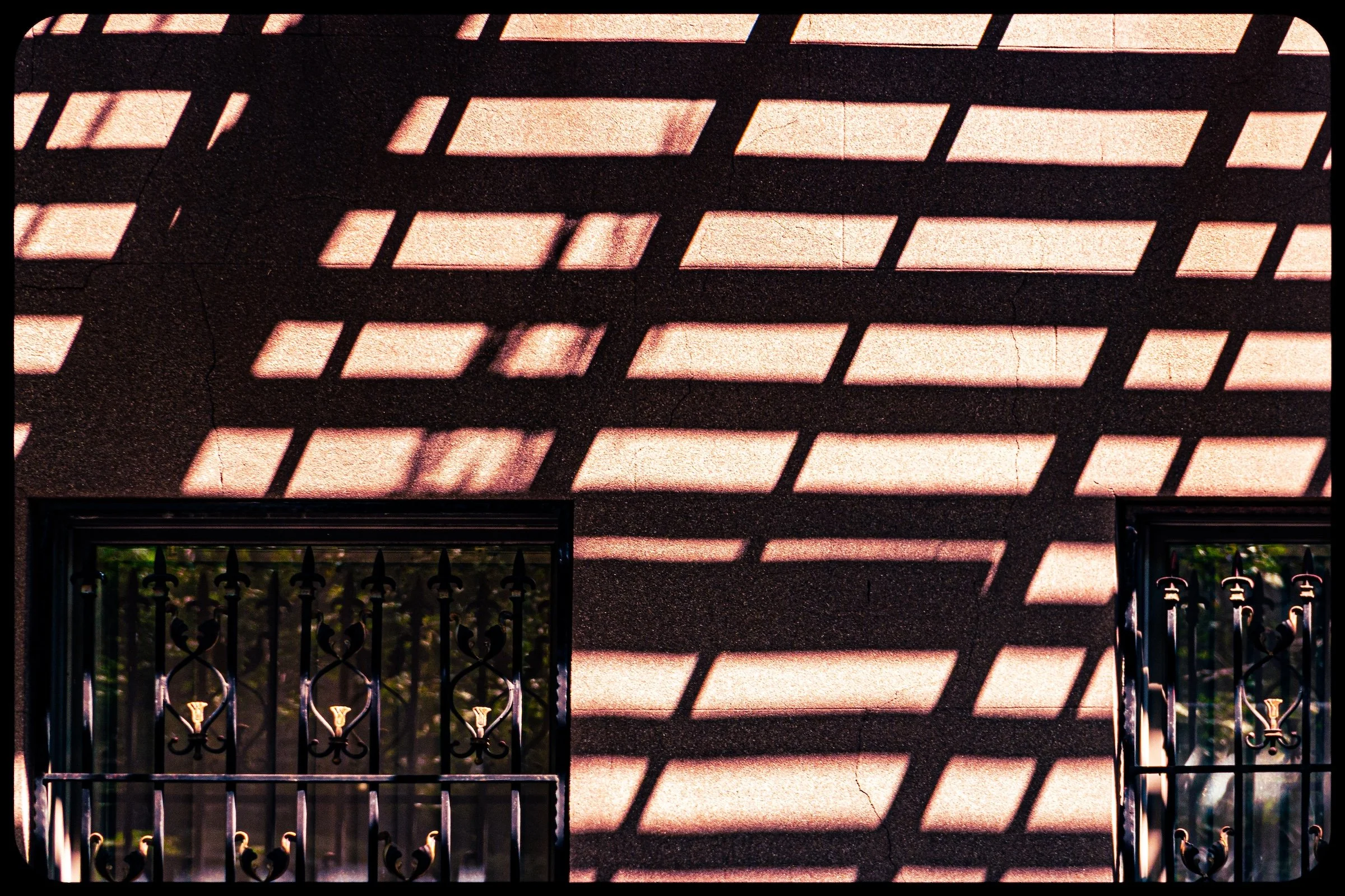
Abstract Light: My visit was punctuated by moments of pure abstraction, such as the play of shadows from a fire escape against a sun-drenched wall in “Escape Shadows.” This focus on "micro-details" helps to bridge the gap between the neighborhood's vast complexity and the quiet, individual moments that define its "Spirit & Legacy."
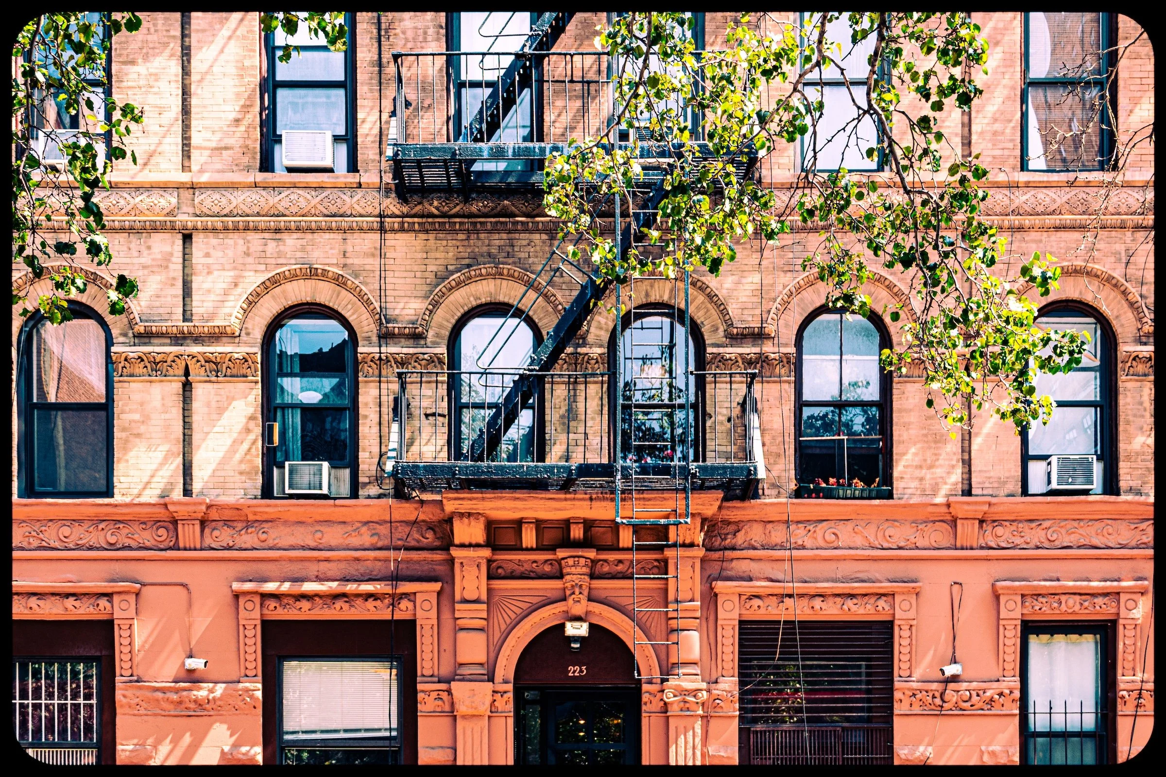
Architectural Rhythms: I also captured the ornamental details that anchor the older street wall, such as the arched windows and decorative cornices in “223 E28”. These historic flourishes provide a human-scaled contrast to the towering modernism that increasingly defines the district's horizon.
Spirit and Legacy
Kips Bay’s identity is one of transformation anchored by continuity. It has been farmland, battleground, factory district, and modernist experiment—yet always tied to the water and to public service. The legacy of Jacob Kip’s farmstead persists in its name; the discipline of medicine and science defines its daily life; and the geometry of its mid-century design continues to influence its skyline.

Kips Bay Field Notes
-
Field Note: August 10, 2014 | 10:00 AM
Conditions: 77°F rising to 81°F | Humidity: 50% (Declining)
I spent nearly three hours in Kips Bay, a neighborhood that served as a masterclass in urban duality. While the towering modern high-rises and gritty, fire-escape-laden facades (“Rusty Escapes”) provide the district's expected character, I found myself drawn to a "hidden secret" of the city: the world of geometry and abstraction. By looking past the sweeping streetscapes of 2nd Avenue (“Second Avenue From E29”), I discovered a rhythmic, repetitive beauty in the oft-overlooked patterns of window AC units and brutalist concrete grids ( “Urban Lattice Shadow & Light”).
Other neighborhoods visited:
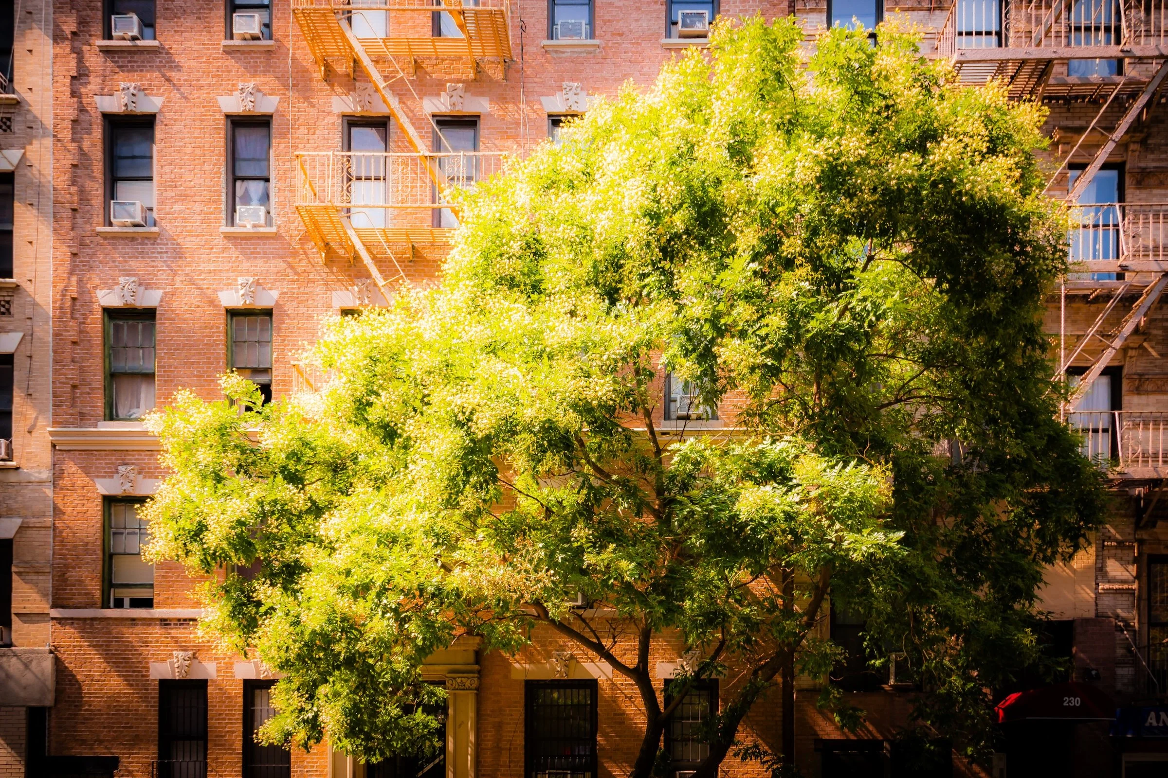
Summer Tree At 230 E25 - Click To Purchase Print
223 E28 - Click To Purchase Print
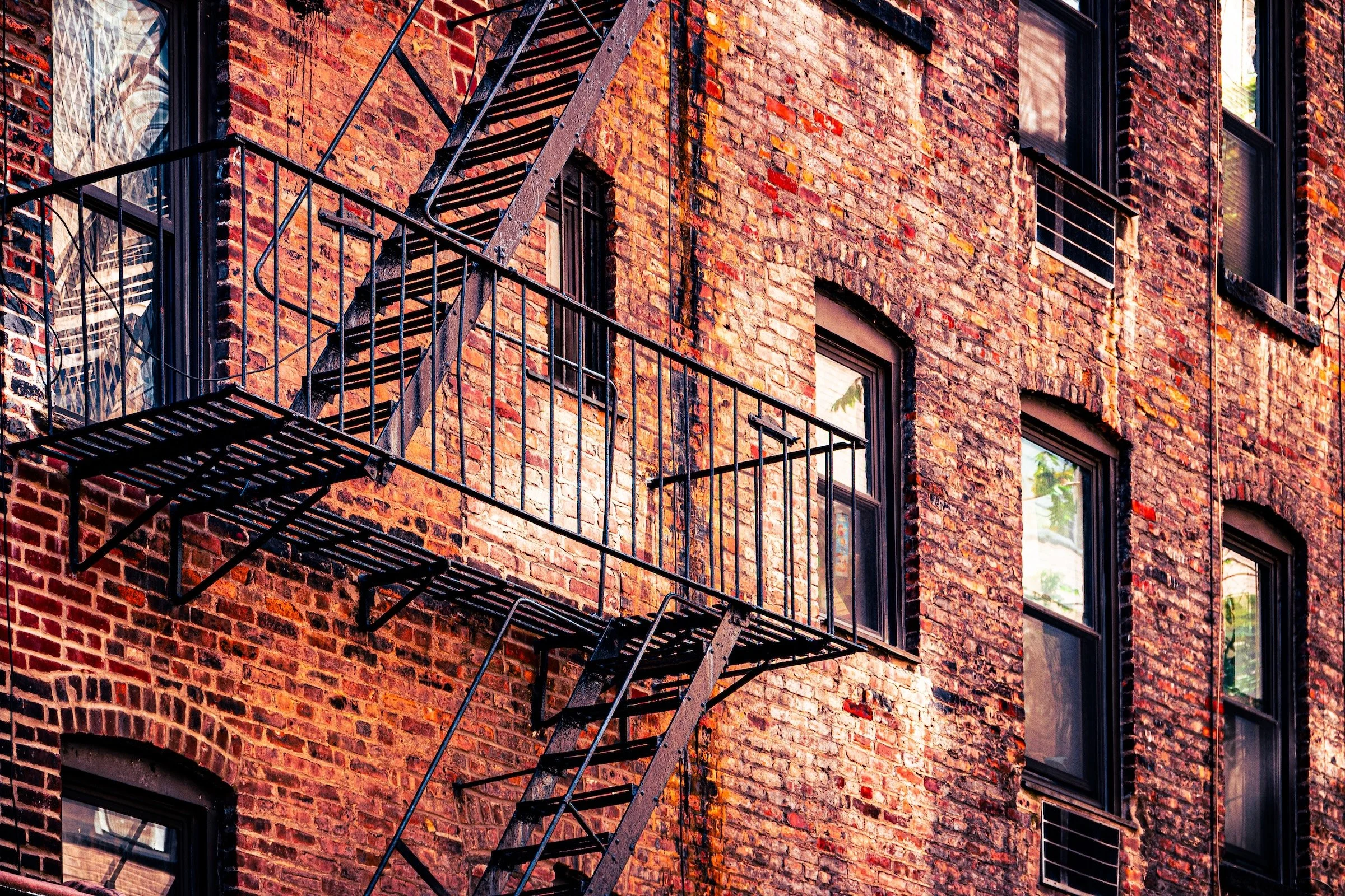
Rusty Escapes - Click To Purchase Print

Second Avenue From E29 - Click To Purchase Print
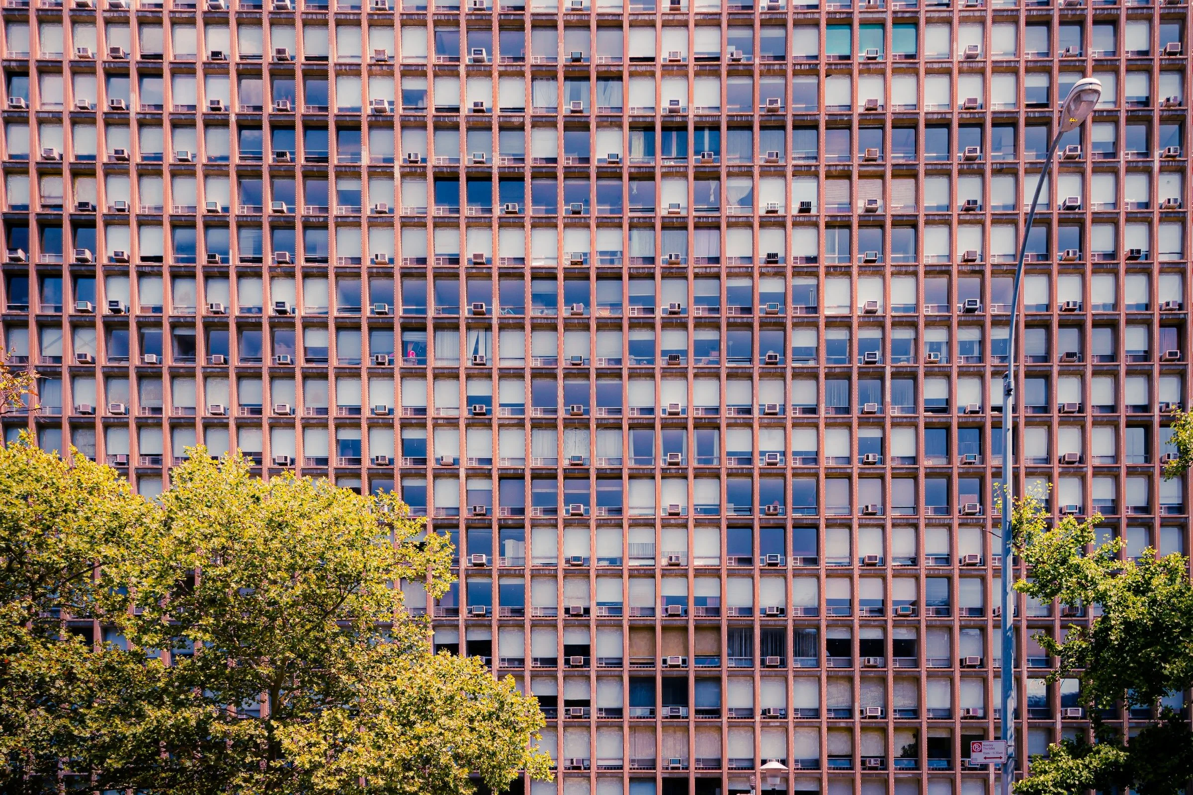
Kips Bay Condos - Click To Purchase Print

Urban Lattice Shadow & Light - Click To Purchase Print
Escape Shadows - Click To Purchase Print

The Eyes of Tammany - Click To Purchase Print
Use this custom Google map to explore where every neighborhood in all five boroughs of New York City is located.
The Five Boroughs
One of New York City’s unique qualities is its organization in to 5 boroughs: Manhattan, Brooklyn, Queens, The Bronx, and Staten Island. These boroughs are part pragmatic administrative districts, and part vestiges of the region’s past. Each borough is an entire county in New York State - in fact, Brooklyn is, officially, Kings County, while Staten Island is, officially Richmond County. But that’s not the whole story …
Initially, New York City was located on the southern tip of Manhattan (now the Financial District) that was once the Dutch colony of New Amsterdam. Across the East River, another city was rising: Brooklyn. In time, the city planners realized that unification between the rapidly rising cities would create commercial and industrial opportunities - through streamlined administration of the region.
So powerful was the pull of unification between New York and Brooklyn that three more counties were pulled into the unification: The Bronx, Queens, and Staten Island. And on January 1, 1898, the City of New York unified two cities and three counties into one Greater City of New York - containing the five boroughs we know today.
But because each borough developed differently and distinctly until unification, their neighborhoods likewise uniquely developed. Today, there are nearly 390 neighborhoods, each with their own histories, cultures, cuisines, and personalities - and each with residents who are fiercely proud of their corner of The Big Apple.


