
PARKCHESTER
The Bronx
Geographic Setting
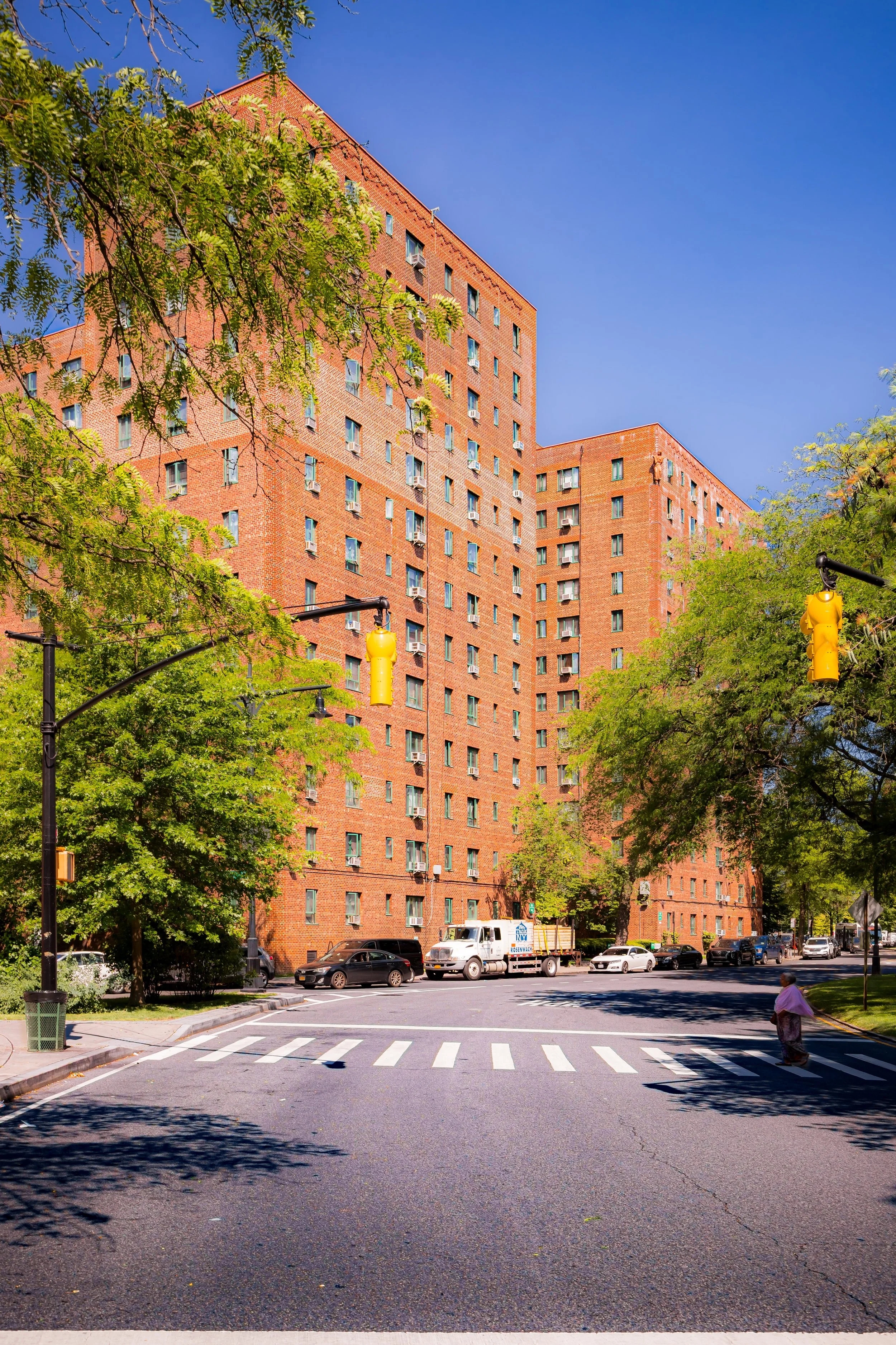
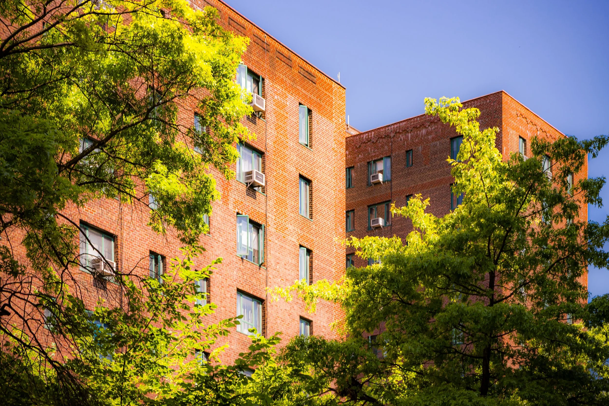
Bounded by East Tremont Avenue to the north, Castle Hill Avenue to the east, Westchester Avenue to the south, and the Cross Bronx Expressway to the southwest, Parkchester occupies a central position in the East Bronx—a self-contained residential community distinguished by its geometric street plan, monumental courtyards, and enduring sense of order amid the surrounding urban sprawl. Centered around Metropolitan Avenue and the Parkchester subway station (6 train), the neighborhood extends in a nearly perfect oval, bordered by broad commercial corridors and inwardly composed of landscaped paths, brick apartment towers, and open plazas that remain among the most carefully planned residential environments in New York City.
Unlike most Bronx neighborhoods that evolved incrementally from older street grids, Parkchester was designed whole cloth: a mid-20th-century experiment in large-scale urban planning and cooperative living. Its internal circulation is defined by wide pedestrian esplanades—Unionport Road, Purdy Street, and Metropolitan Oval—lined with red-brick art deco buildings adorned with whimsical terra-cotta reliefs. Anchored by St. Raymond’s Church, Metropolitan Oval Park, and the bustling shopping district along East Tremont Avenue, Parkchester continues to function as a self-contained micro-city, where residential life, recreation, and commerce intertwine seamlessly within a single design.
Etymology
The name “Parkchester” was coined in the 1930s by the Metropolitan Life Insurance Company, which developed the complex. It combines “Park”—for its expansive landscaped courtyards—and “Chester,” a suffix derived from the Old English ceaster, meaning a fortified settlement or town. The term thus implied a town within a park—a self-sufficient, orderly community blending suburban greenery with urban accessibility.
Metropolitan Life used the name to brand an idealized vision of modern city living: clean, efficient, and secure, a marked contrast to the overcrowded tenements of prewar New York. That aspirational identity has endured—long after the corporate planners departed—as part of Parkchester’s local lexicon and pride.
The Neighborhood
Origins through the 19th Century
Before Parkchester’s construction, the area formed part of the rural Throgs Neck–Unionport tract, a landscape of farms, meadows, and small roads leading to Westchester Creek. By the late 19th century, it lay within the Town of Westchester, annexed to New York City in 1895. Development remained sparse; only a scattering of frame houses and light industrial buildings occupied the area near Westchester Avenue, then a major trolley and rail corridor connecting the South Bronx to Pelham Bay.
As the city’s population expanded northward in the early 20th century, the site’s size and flat topography attracted attention from developers. The opening of the Pelham Bay Line (IRT 6 train) in 1920 transformed the surrounding area, turning East Tremont and Westchester Avenues into vital commercial corridors. Yet the tract that would become Parkchester remained undeveloped until the 1930s, when it was purchased by Metropolitan Life—a company already experimenting with large-scale housing at Manhattan’s Stuyvesant Town.
Early 20th Century: Vision and Construction of a Planned City
Construction of Parkchester began in 1939 and was completed in 1942, a period that coincided with the waning years of the Great Depression and the dawn of America’s wartime mobilization. Designed by the architectural firm Emery Roth & Sons in collaboration with Metropolitan Life’s in-house planning division, the project represented one of the most ambitious private housing developments in U.S. history: 171 acres, 171 buildings, and 12,271 apartments, built at a cost of approximately $50 million.
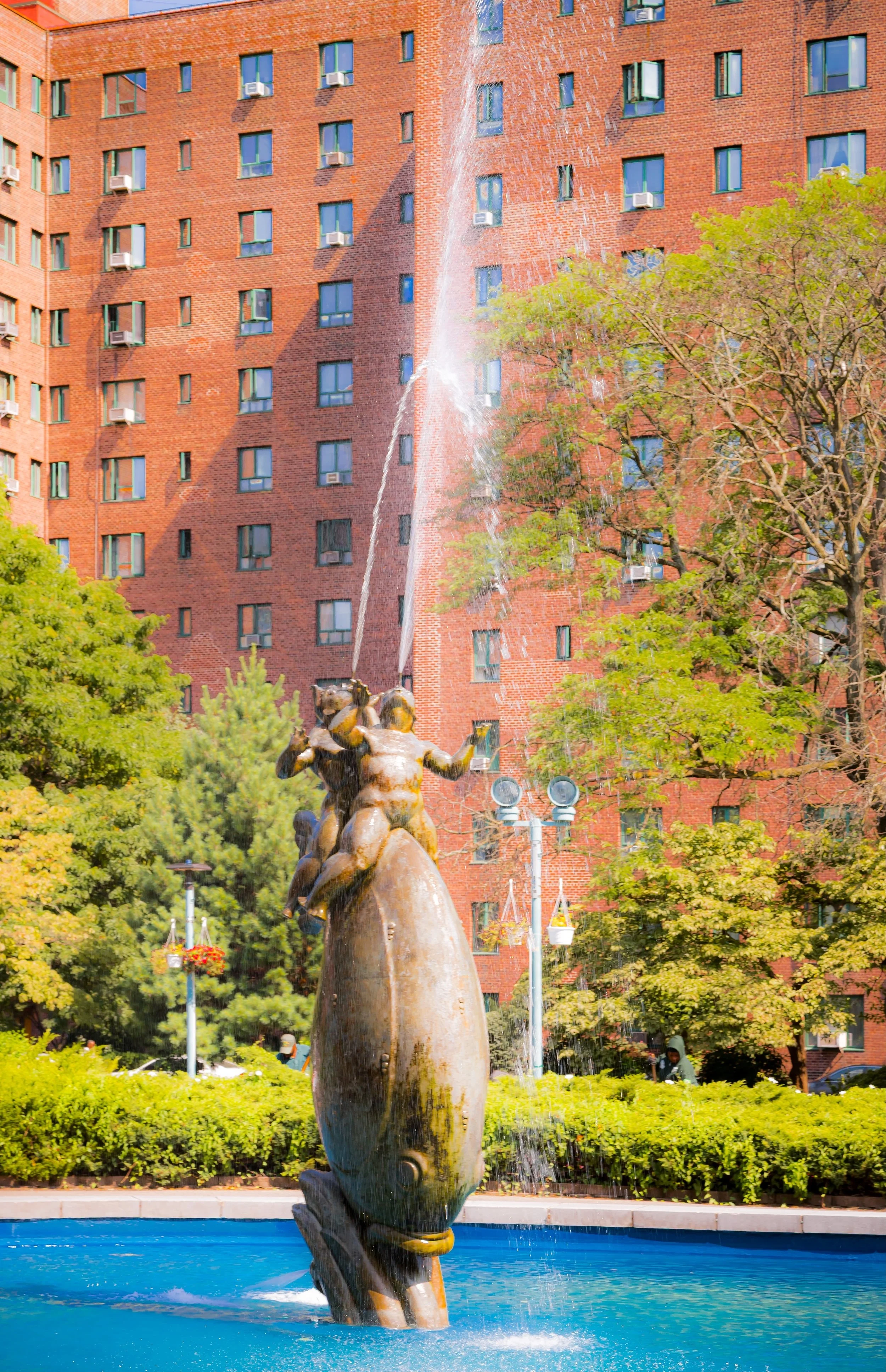
Parkchester was conceived as a self-sustaining “satellite city” within New York, combining modern architecture, open space, and strict zoning control. Influenced by the ideals of the Garden City movement, it placed residential towers in a landscaped setting rather than on a traditional street grid. Broad internal greens, pedestrian walkways, and ornamental plazas replaced alleys and stoops. Sculptural details by artists such as Raymond Granville Barger and Joseph Kiselewski—depicting dolphins, children, and mythological creatures—added a humanizing touch to the austere brick modernism.
When completed, Parkchester included schools, a movie theater, department stores, and even its own police and fire precincts. Advertised as “A City Within a City,” it attracted primarily middle-income white families, many of them veterans and office workers seeking stability and modernity in a rapidly changing metropolis.
Parkchester Video Coming Soon
Mid–Late 20th Century: From Private Ideal to Public Reality
In the decades following World War II, Parkchester flourished as a stable, middle-class enclave. Its meticulously maintained lawns, efficient management, and proximity to transit made it one of the Bronx’s most desirable addresses. The neighborhood’s Metropolitan Oval, a central green ringed by fountains and benches, became its civic heart—a gathering place for residents of all ages.
However, Parkchester’s founding exclusivity also mirrored the racial segregation of mid-century America. Metropolitan Life enforced restrictive leasing practices that excluded African-American and Latino families, a policy challenged but not overturned until the 1950s–1960s. As broader social and economic shifts swept through the Bronx, Parkchester gradually diversified. Many original tenants moved to the suburbs, replaced by Puerto Rican, African-American, and South Asian families who found in Parkchester’s apartments both affordability and security.
In 1968, Metropolitan Life sold the complex to a consortium of investors, ending corporate management. By the 1970s, Parkchester was grappling with the same challenges as the wider Bronx: aging infrastructure, rising crime, and urban disinvestment. Yet its design—physically enclosed, socially cohesive—helped it weather the crisis with remarkable resilience. The community organized to preserve its housing quality, and many buildings converted to cooperative ownership, laying the groundwork for renewal.
21st Century: Diversity, Renewal, and the Modern Bronx Mosaic
Today, Parkchester stands as one of the Bronx’s most dynamic and diverse neighborhoods—a living embodiment of the borough’s evolution. The population represents a remarkable cross-section of New York’s global fabric: Bangladeshi, Dominican, West African, Puerto Rican, and South Asian families live alongside older Irish and Italian residents in a community of more than 25,000 people.
The Parkchester Preservation Company, established in the 1990s, oversees management and restoration of the complex, balancing preservation with modernization. Restorations of façades, fountains, and sculptures have revived the neighborhood’s mid-century elegance, while upgrades to plumbing, electrical systems, and elevators have ensured its longevity. The Metropolitan Oval, meticulously landscaped and dotted with trees and sculptures, remains the symbolic and physical center—a tranquil green at the heart of dense urban life.
Commercially, East Tremont Avenue and White Plains Road bustle with shops, halal restaurants, bakeries, and boutiques that mirror the neighborhood’s global identity. Parkchester Station connects directly to Manhattan, while the district’s grid of wide boulevards and enclosed courtyards continues to support a pedestrian-friendly rhythm rare in modern city design.
Despite its scale, Parkchester retains an intimate sense of community: neighbors know one another, cultural festivals fill the courtyards, and the very layout of the place—its balanced geometry and central green—continues to foster connection.
Parkchester Photo Gallery
Spirit and Legacy
The spirit of Parkchester lies in its dual identity: both a meticulously designed artifact of early modern planning and a thriving, multicultural neighborhood that has outgrown its original vision. What began as a corporate experiment in idealized living has become a lived-in, evolving cityscape—proof that design, community, and adaptability can endure across generations.
New York City
Use this custom Google map to explore where every neighborhood in all five boroughs of New York City is located.
The Five Boroughs
One of New York City’s unique qualities is its organization in to 5 boroughs: Manhattan, Brooklyn, Queens, The Bronx, and Staten Island. These boroughs are part pragmatic administrative districts, and part vestiges of the region’s past. Each borough is an entire county in New York State - in fact, Brooklyn is, officially, Kings County, while Staten Island is, officially Richmond County. But that’s not the whole story …
Initially, New York City was located on the southern tip of Manhattan (now the Financial District) that was once the Dutch colony of New Amsterdam. Across the East River, another city was rising: Brooklyn. In time, the city planners realized that unification between the rapidly rising cities would create commercial and industrial opportunities - through streamlined administration of the region.
So powerful was the pull of unification between New York and Brooklyn that three more counties were pulled into the unification: The Bronx, Queens, and Staten Island. And on January 1, 1898, the City of New York unified two cities and three counties into one Greater City of New York - containing the five boroughs we know today.
But because each borough developed differently and distinctly until unification, their neighborhoods likewise uniquely developed. Today, there are nearly 390 neighborhoods, each with their own histories, cultures, cuisines, and personalities - and each with residents who are fiercely proud of their corner of The Big Apple.


