GRYMES HILL
Staten Island
Geographic Setting
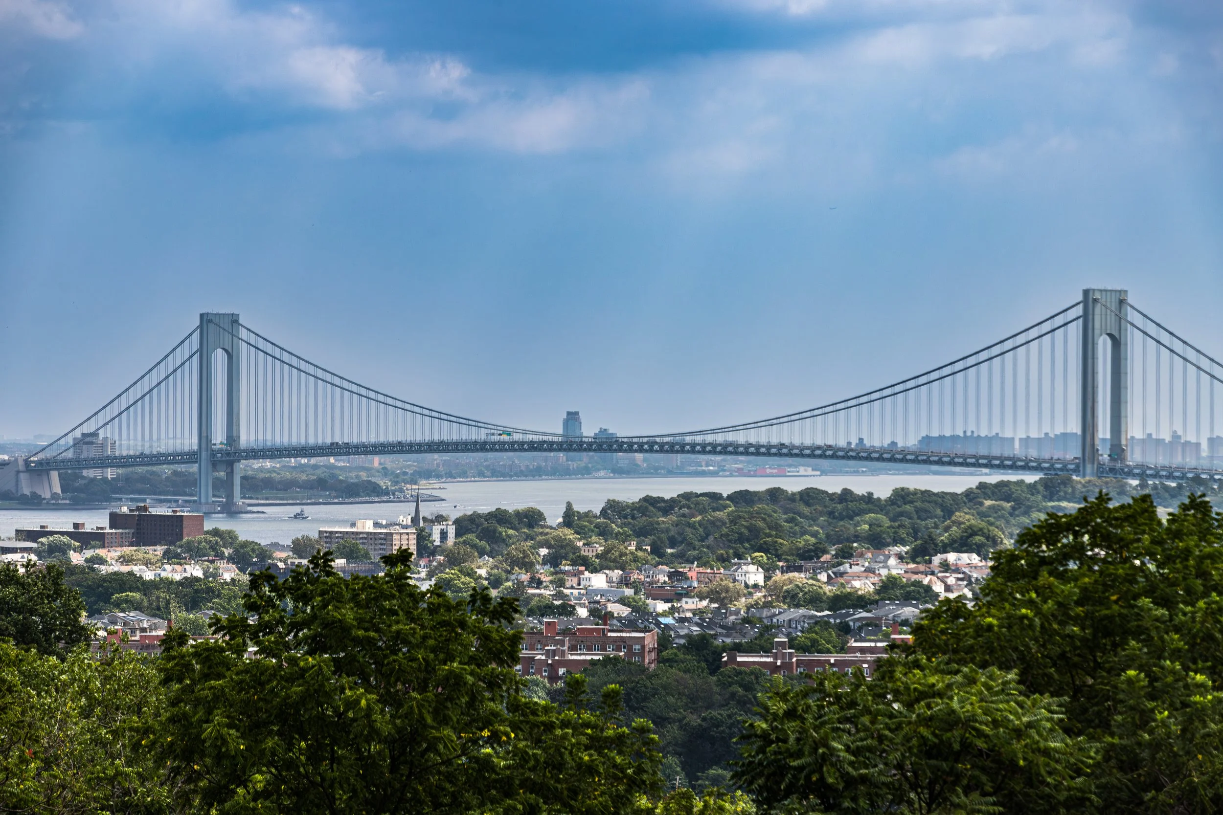
Bounded by Van Duzer Street to the east, Richmond Road to the southeast, the Staten Island Expressway to the south, and a western boundary tracing Clove Road north to Howard Avenue, then north on Howard to Highland Avenue, north on Highland to Arlo Road, east on Arlo to Silver Mount Cemetery, north to Theresa Place, east on Ada Place to Howard Avenue, and north again on Howard to the Staten Island Expressway, Grymes Hill occupies one of the most dramatic elevations in all of New York City. Rising steeply from the harbor plain of Tompkinsville and Concord to the crest of Staten Island’s central moraine, the neighborhood commands sweeping views of the New York Harbor, Brooklyn, and Lower Manhattan.
The terrain—rugged, wooded, and deeply contoured—defines the character of the community. Winding roads such as Howard Avenue, Prospect Avenue, and Ralph Place ascend the hillside through dense groves of oak and maple, revealing stately homes perched on terraces and ridges. At its summit lie institutions that anchor both the skyline and the community: Wagner College and St. John’s University Staten Island Campus, whose verdant campuses occupy the hilltop plateau. Below them, residential enclaves blend mid-century modern homes, early 20th-century mansions, and postwar apartments, all united by the commanding vista that makes Grymes Hill one of Staten Island’s—and the city’s—most scenic neighborhoods.
Etymology
The name Grymes Hill honors Suzette Grymes Tompkins, wife of Daniel D. Tompkins, the fourth governor of New York (1807–1817), U.S. Vice President under James Monroe, and one of Staten Island’s most influential early landowners. The Grymes family, of Virginia origin, became intertwined with the Tompkins through marriage, and their name came to designate the estate they established on the heights overlooking the harbor. The name “Grymes Hill” first appeared in the mid-19th century, when the Tompkins-Grymes estate was subdivided and promoted as one of Staten Island’s most desirable residential districts.
Its aristocratic name, along with the views it commanded, gave the area an air of refinement that it has never lost—a reputation for elevation not just of landscape, but of culture and community.
The Neighborhood
Origins through the 19th Century
In the colonial era, the slopes of what would become Grymes Hill were part of the rural Town of Castleton, a landscape of farms and woodlots overlooking the ferry approaches to Manhattan. The ridge’s steep grades limited cultivation, leaving much of the land forested and sparsely inhabited. By the late 18th century, wealthy merchants and political figures, drawn by the pure air and harbor views, began acquiring parcels for country estates. Among them was Daniel D. Tompkins, who built his home nearby in what is now Tompkinsville, and whose extended family would later settle on the adjoining heights.
In the early 1800s, the Grymes family established an estate on the ridge, building a grand home surrounded by gardens and carriage drives. The area quickly became a magnet for Staten Island’s elite, who constructed villas and summer houses along what would become Howard Avenue. The view—stretching from the Narrows to the Statue of Liberty—was famed even in its day; visitors from Manhattan likened it to the great hill towns of Europe.
By the mid-19th century, the Staten Island Expressway’s eventual path was still farmland and meadow, but above it, Grymes Hill had already acquired its character: a wooded elevation of wealth and contemplation, where landscape and architecture coexisted in cultivated harmony.
Early 20th Century: Suburban Prestige and Academic Roots
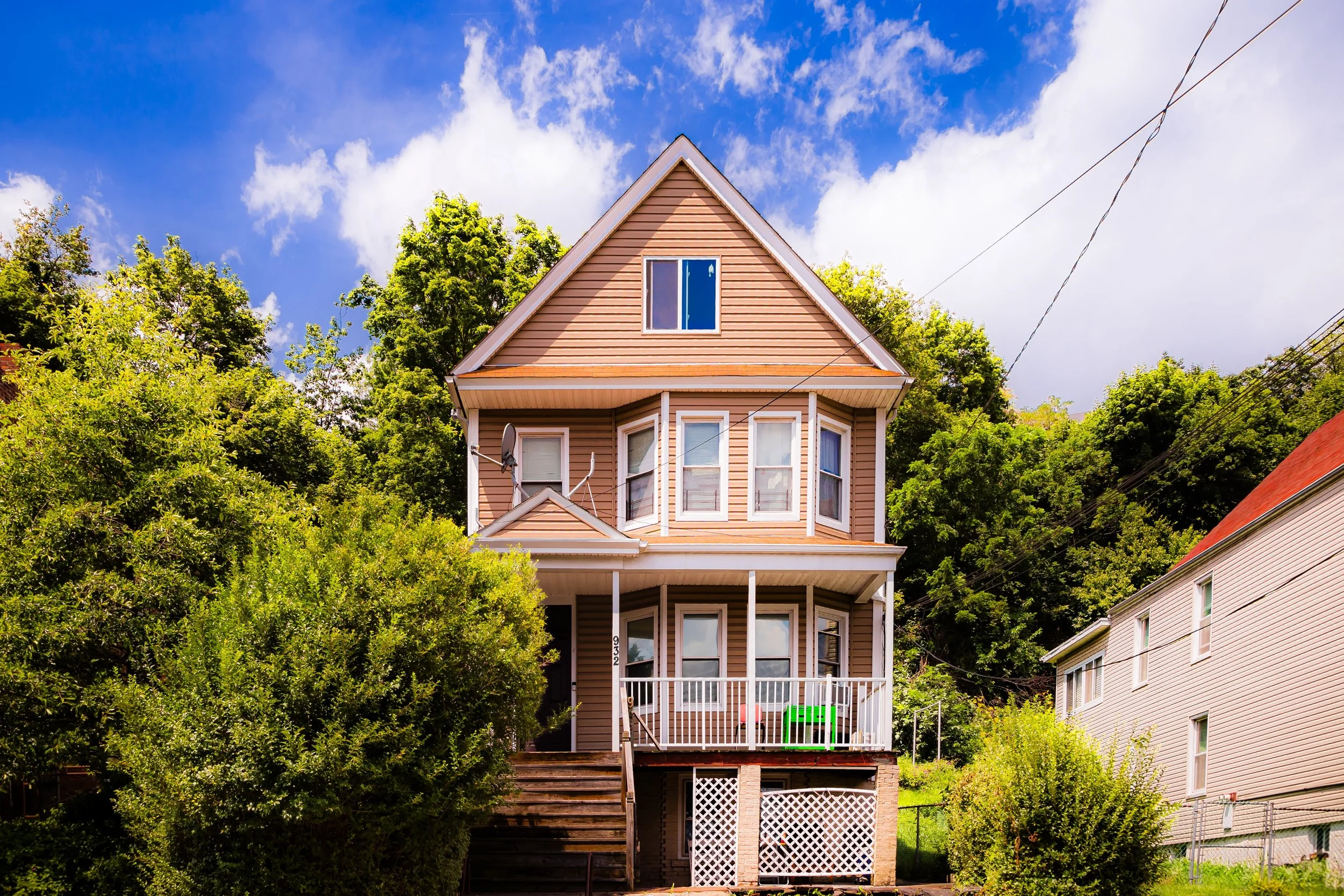
The early 1900s brought measured suburbanization to Grymes Hill, as Staten Island’s ferry connections to Manhattan strengthened and the North Shore grew more urbanized. Wealthy families subdivided portions of their estates into large residential lots, leading to the construction of substantial homes in Tudor Revival, Colonial, and Mediterranean styles along the ridge.
The neighborhood’s character as an intellectual and spiritual enclave emerged during this period. In 1918, the Wagner Memorial Lutheran College (now Wagner College) relocated to the hilltop from Rochester, New York, transforming the landscape with its red-brick academic buildings and sweeping lawns. Its establishment set a precedent for the area as an educational hub; later, the Staten Island campus of St. John’s University would join it nearby, further anchoring the hill’s institutional presence.
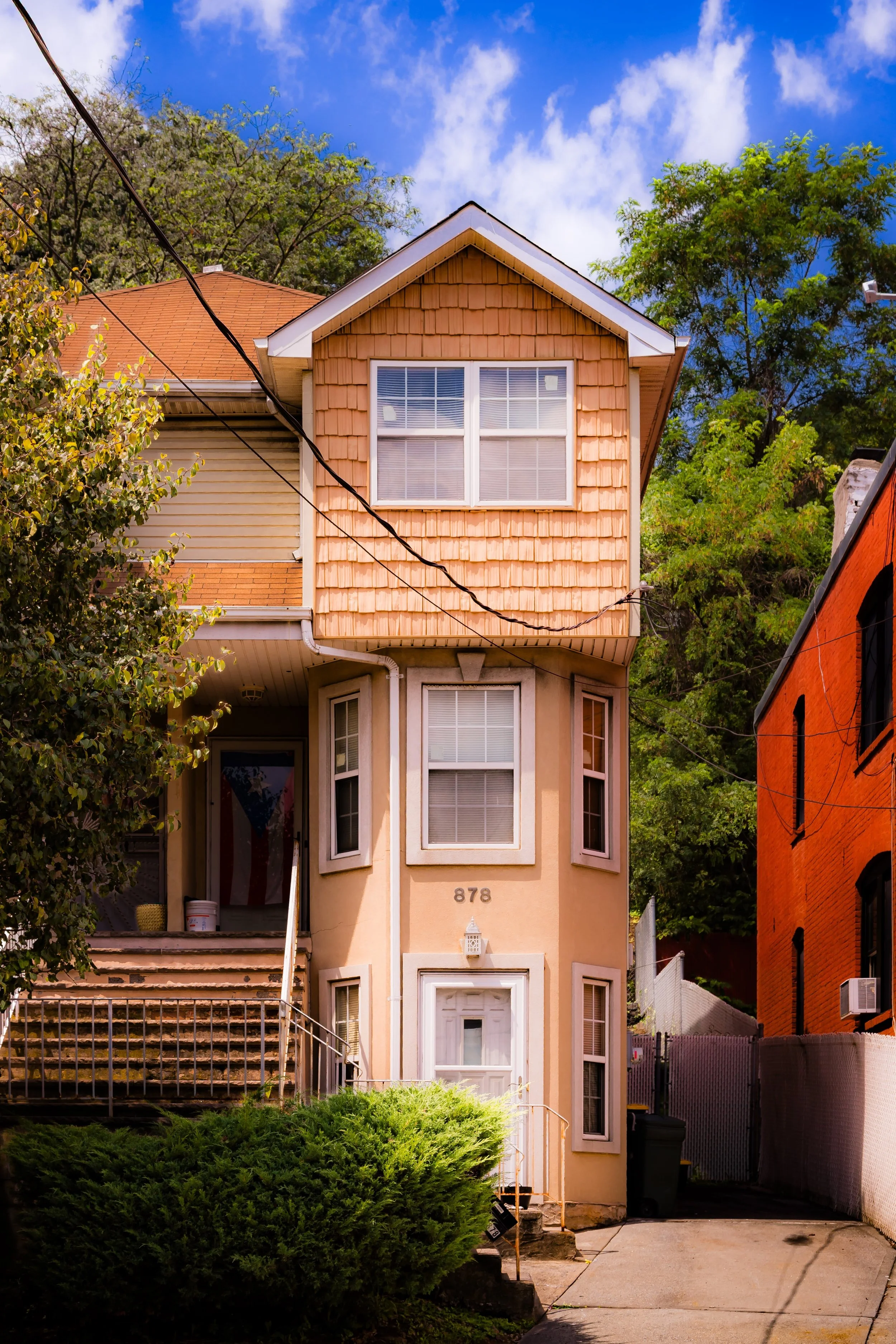
Throughout the interwar years, Grymes Hill remained one of Staten Island’s most prestigious addresses. Residents valued its seclusion, elevation, and architectural distinction. The winding topography resisted dense development, preserving its woodland feel even as the city expanded around it. The neighborhood’s mixture of mansions, collegiate campuses, and scenic drives made it a distinctive counterpart to the borough’s flatter, more suburban districts.
Grymes Hill Video Coming Soon
Mid–Late 20th Century: Academic Heights and Urban Transformation
The post–World War II decades reshaped Staten Island’s landscape, but Grymes Hill retained its singular identity. The completion of the Staten Island Expressway (1964) carved through the lower slopes of the hill, linking the Verrazzano-Narrows Bridge to the island’s interior, but the core of the neighborhood remained insulated by elevation. The expressway’s construction brought new accessibility, attracting a broader professional class while allowing longtime families to remain.
In the 1950s and 1960s, a wave of mid-century modernist architecture appeared along Howard Avenue and its connecting roads—flat-roofed homes, cantilevered balconies, and panoramic windows designed to capture the view. Apartment complexes such as the Grymes Hill Apartments and The Woodbrook introduced multi-family living without overwhelming the landscape. Meanwhile, Wagner College flourished, its neo-Georgian campus becoming both an academic center and a cultural landmark visible from the harbor below.
The 1970s and 1980s saw demographic diversification as professionals, educators, and artists joined the neighborhood’s ranks. The combination of convenience, scenery, and intellectual life kept Grymes Hill vibrant even as other parts of the North Shore struggled with urban decline. The wooded ravines and steep roads preserved its air of retreat—a hillside enclave within sight of Manhattan’s skyline.
21st Century: A Hill of Heritage and Horizon
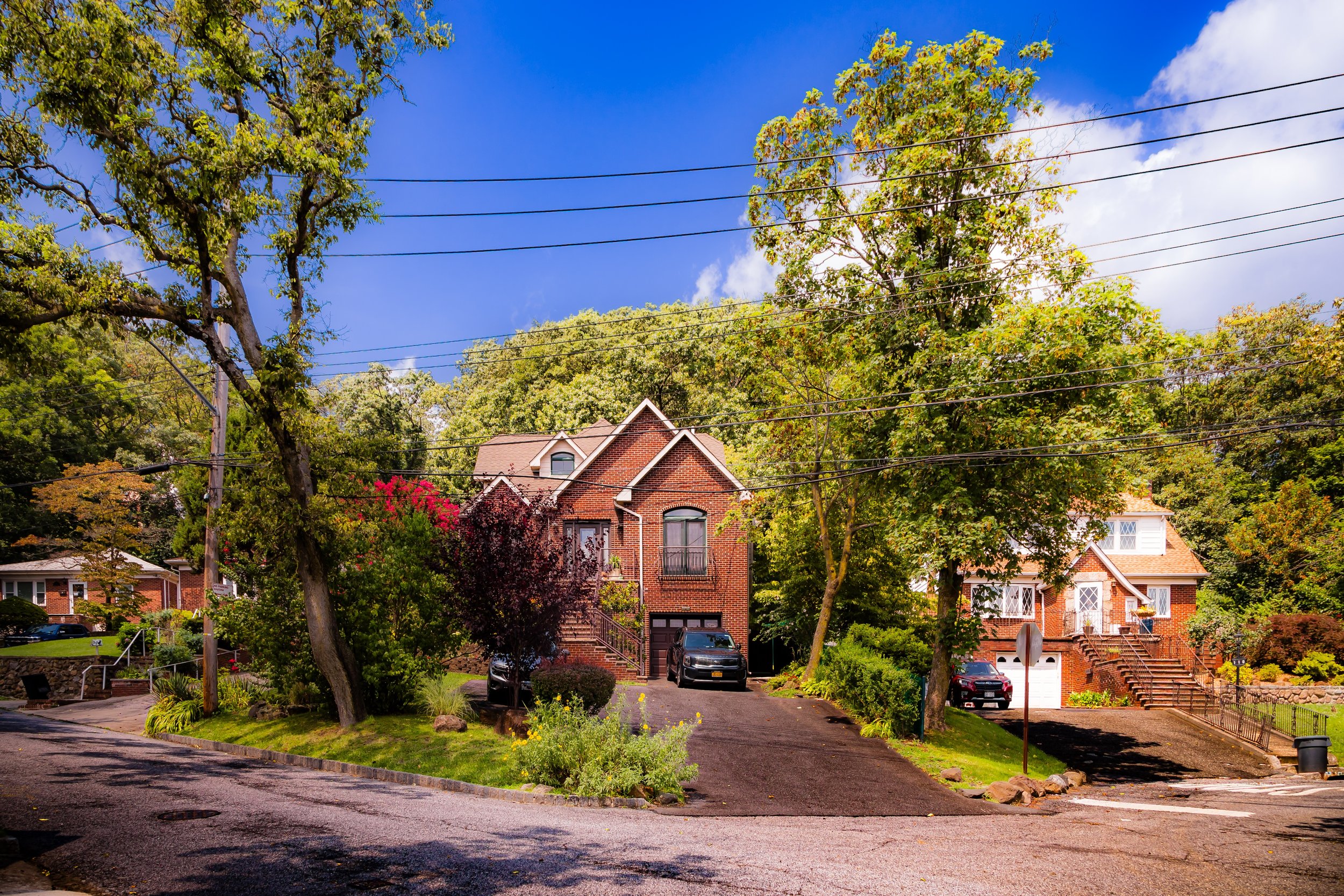
In the 21st century, Grymes Hill remains one of Staten Island’s most distinctive neighborhoods—a blend of academic, residential, and environmental richness. Wagner College and St. John’s University continue to define its skyline, their lawns and towers offering open green spaces and cultural events that unite students and residents alike. The hill’s residential areas remain a study in contrast and continuity: stately early 20th-century homes beside sleek modern renovations, all bound together by forested slopes and panoramic views.
Environmental preservation and slope stabilization have become central concerns, as the community works with city agencies to manage runoff and protect the wooded escarpments that define its identity. The nearby Silver Lake Park and Clove Lakes Park provide additional green continuity, linking Grymes Hill to Staten Island’s central park system.
Culturally, the neighborhood reflects Staten Island’s growing diversity while retaining its tradition of civic engagement and education. Local associations and university partnerships sponsor lectures, art exhibitions, and ecological programs that reinforce the hill’s reputation as both a literal and intellectual high ground. Its elevated roads, often quiet except for the wind in the trees, remain among the borough’s most beautiful drives—curving ribbons of asphalt framed by stone walls and glimpses of the distant city skyline.
Grymes Hill Photo Gallery
Spirit and Legacy
The spirit of Grymes Hill lies in its elevation—in geography, vision, and aspiration. It has always been a place of perspective: a vantage point from which to see the harbor, to contemplate the city, and to imagine broader horizons. From the Grymes family’s 19th-century estate to the academic campuses that now crown its heights, the neighborhood has nurtured a tradition of reflection, learning, and stewardship.
Its legacy endures in the interplay of nature and intellect, of landscape and life. The hill’s wooded slopes and open lawns remain sanctuaries amid the sprawl, reminding Staten Islanders that even within the city, one can live among trees, light, and expansive views.
New York City
Use this custom Google map to explore where every neighborhood in all five boroughs of New York City is located.
The Five Boroughs
One of New York City’s unique qualities is its organization in to 5 boroughs: Manhattan, Brooklyn, Queens, The Bronx, and Staten Island. These boroughs are part pragmatic administrative districts, and part vestiges of the region’s past. Each borough is an entire county in New York State - in fact, Brooklyn is, officially, Kings County, while Staten Island is, officially Richmond County. But that’s not the whole story …
Initially, New York City was located on the southern tip of Manhattan (now the Financial District) that was once the Dutch colony of New Amsterdam. Across the East River, another city was rising: Brooklyn. In time, the city planners realized that unification between the rapidly rising cities would create commercial and industrial opportunities - through streamlined administration of the region.
So powerful was the pull of unification between New York and Brooklyn that three more counties were pulled into the unification: The Bronx, Queens, and Staten Island. And on January 1, 1898, the City of New York unified two cities and three counties into one Greater City of New York - containing the five boroughs we know today.
But because each borough developed differently and distinctly until unification, their neighborhoods likewise uniquely developed. Today, there are nearly 390 neighborhoods, each with their own histories, cultures, cuisines, and personalities - and each with residents who are fiercely proud of their corner of The Big Apple.


