SOUTH STREET SEAPORT
Manhattan
Geographic Setting
Bounded by Brooklyn Bridge to the north and John Street to the south, and stretching roughly from Pearl Street eastward to the East River, the South Street Seaport occupies one of the most historically resonant waterfronts in New York City. Nestled at the foot of the Financial District, this riverside enclave stands as the city’s oldest surviving maritime precinct—a district where the cobblestones, timber piers, and masts of tall ships evoke the era when New York rose to global prominence through trade and the sea.
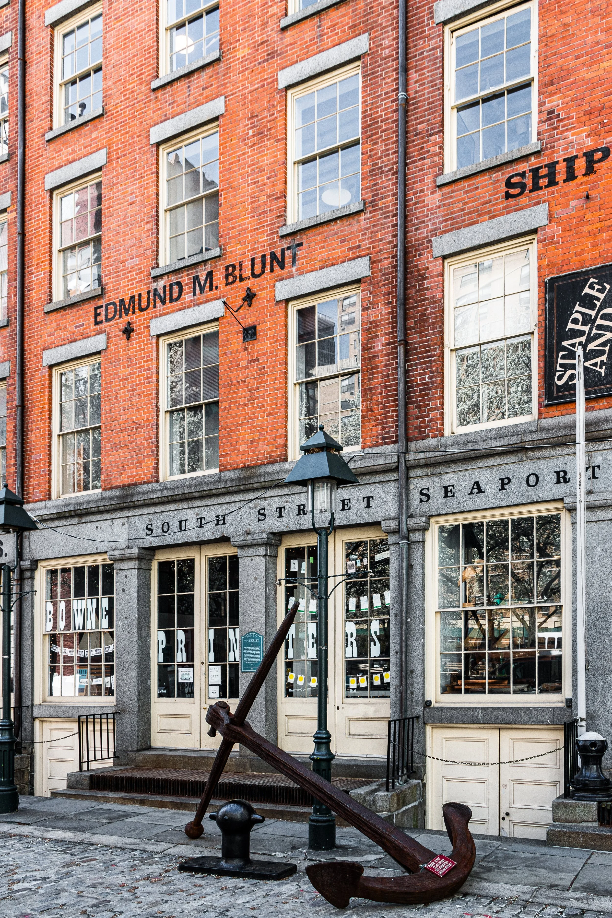
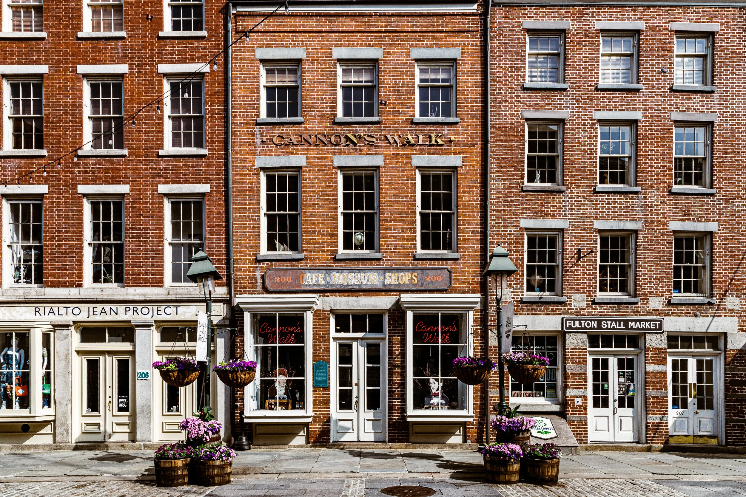
The neighborhood’s compact geography centers on Fulton Street, South Street, and Front Street, where restored 18th- and 19th-century mercantile buildings—brick countinghouses, warehouses, and taverns—frame views of the East River, Brooklyn Bridge, and Governors Island beyond. The surviving street grid predates the Commissioners’ Plan of 1811, retaining its colonial irregularity and intimacy. Today, the South Street Seaport is both museum and marketplace: a rare surviving fragment of early New York’s maritime cityscape, layered with centuries of commerce, catastrophe, and renewal.
Etymology and Origins
The Seaport’s name derives simply from South Street, the waterfront thoroughfare that once rimmed the eastern edge of Manhattan, and from its role as the city’s historic seaport—its lifeline to the Atlantic world. The area’s origins date to the 1620s, when Dutch settlers of New Amsterdam established wharves and slipways along the sheltered East River shore. After the British takeover in 1664, this stretch became the Great Dock, the nucleus of New York’s early shipping industry.
The name “South Street Seaport” was revived in the 20th century by preservationists seeking to distinguish this historic cluster of buildings and piers from the encroaching modern Financial District. Their use of the term formalized what had long been implicit: that this was not merely a place of commerce, but the cradle of New York’s maritime identity.
The Neighborhood
18th–19th Centuries: The Port of Empire
By the late 18th century, the area around Fulton Street and South Street had become the beating heart of the young nation’s economy. Its wharves handled everything from West Indian sugar and molasses to imported textiles, tea, and tobacco. Ship chandlers, sailmakers, ropewalks, and countinghouses crowded the waterfront, while nearby taverns and boardinghouses catered to sailors, merchants, and dockworkers.
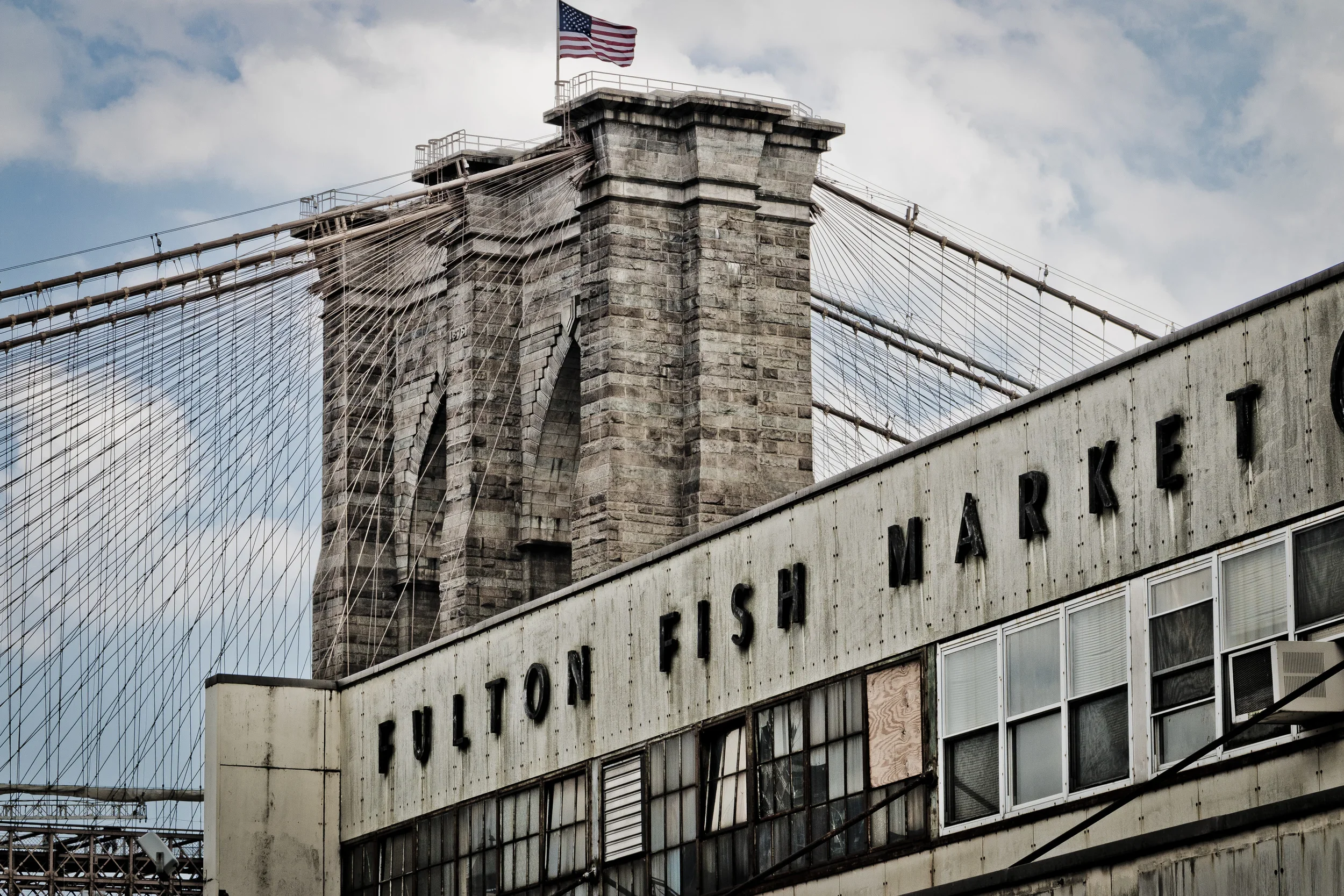
The Fulton Fish Market, established in 1822, became the city’s most enduring institution—an open-air bazaar of clattering crates and shouted bids that supplied fish to restaurants and households across the metropolis for nearly two centuries. The market’s iron sheds and pungent bustle symbolized the ceaseless labor that sustained the city’s wealth.
During the mid-19th century, South Street was a spectacle of maritime energy: rows of tall-masted ships from around the world docked at its piers, their cargoes offloaded into the Greek Revival countinghouses that still line Front Street and Fulton Street today. Among the surviving examples are Schermerhorn Row (1811–12), a block of mercantile buildings whose Flemish-bond brickwork and dormered roofs form one of the oldest commercial streetscapes in New York.
Yet beneath its prosperity lay hardship: longshoremen and immigrants labored under brutal conditions, and the waterfront teemed with saloons and sailors’ boardinghouses. The Seaport’s vitality was inseparable from its grit—a world of commerce and chaos bound to the tides.
Late 19th–Early 20th Century: Industrial Supremacy and Decline
By the 1870s, the East River waterfront had been eclipsed by the deeper waters of the Hudson River piers on Manhattan’s west side, where steamships could dock more easily. Yet the South Street area continued to thrive as a wholesale hub. The Fulton Fish Market expanded steadily, drawing workers from across the five boroughs before dawn each morning. Refrigeration, electrification, and steel-frame construction modernized operations but altered little of the district’s outward appearance.
However, as container shipping and port facilities shifted to New Jersey after World War II, the East River piers fell silent. By the 1950s, the Seaport’s warehouses were largely abandoned; cobblestone streets lay in disrepair, and the area’s future seemed doomed to demolition. It was at this low point that a group of preservationists, led by architect and historian Peter Stanford and writer Norman Brouwer, recognized the site’s unique historical value.
Their efforts, launched in the 1960s, would eventually transform decay into one of New York’s first large-scale heritage preservation successes.
South Street Seaport Photographic Tour
Mid–Late 20th Century: Preservation and the Birth of a Museum District
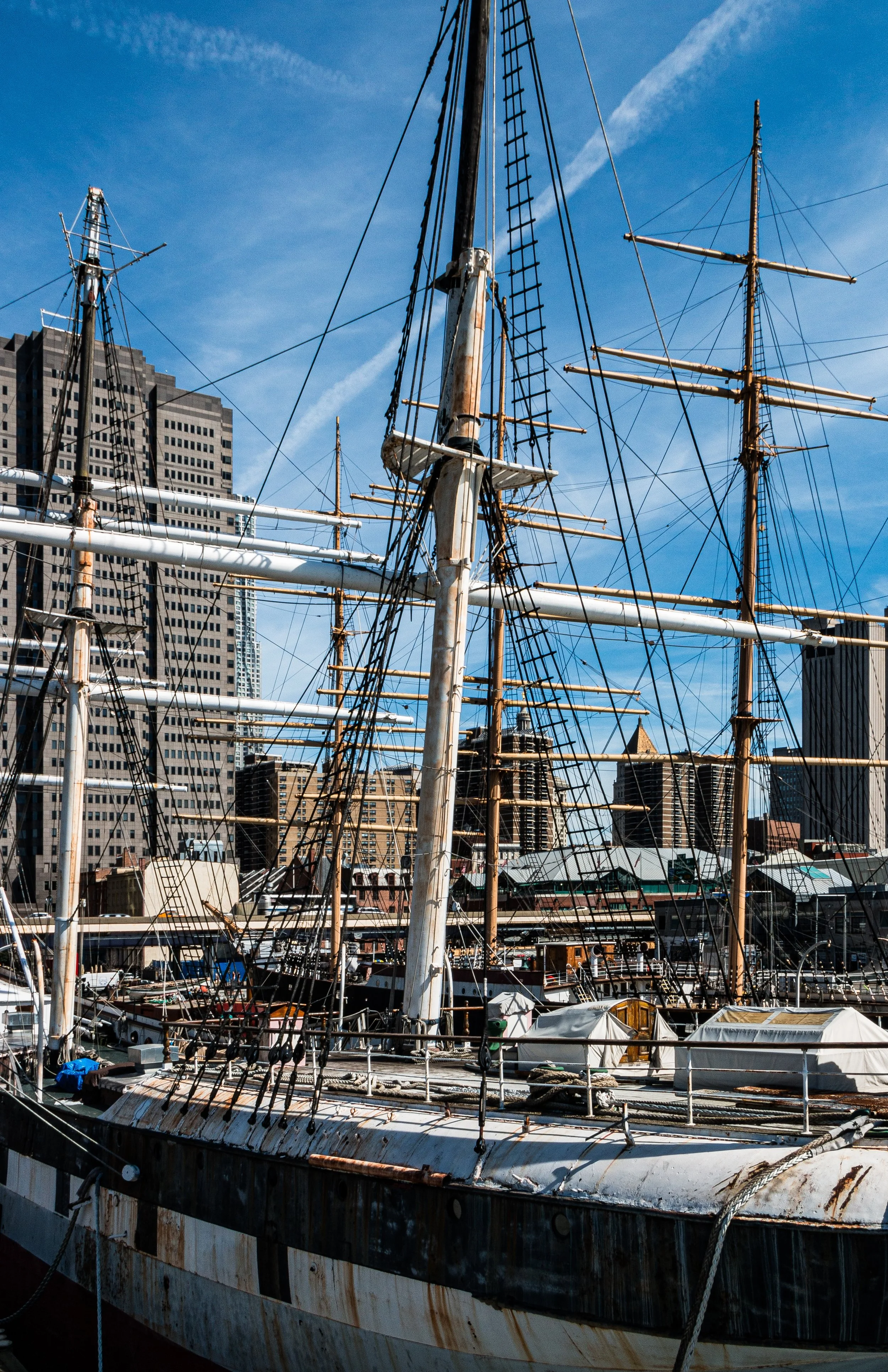
In 1967, the South Street Seaport Museum was founded to preserve and interpret the maritime heritage of the port. The museum acquired historic vessels—including the Wavertree (1885), a British iron-hulled sailing ship; the Peking (1911), a four-masted barque; and the lightship Ambrose (LV-87)—anchoring them along restored piers as floating exhibits. The surrounding warehouses were restored, cobblestones relaid, and the Schrmerhorn Row buildings adapted into galleries and shops.
This vision of a living museum—a blend of preservation, education, and commerce—was revolutionary in its time. The Seaport became a model for urban waterfront renewal worldwide. By the 1980s, the district had been reborn as both cultural attraction and leisure destination, complete with shops, restaurants, and the Fulton Market Building (1983). Its historic authenticity, combined with views of the East River and Brooklyn Bridge, gave it a romantic appeal unmatched elsewhere in Lower Manhattan.
21st Century: Renewal after the Storms
The 21st century brought both revitalization and trial. Hurricane Sandy (2012) devastated the district, flooding historic buildings and damaging piers. Yet from this disaster emerged a renewed commitment to preservation and resilience. The South Street Seaport Museum restored its fleet and exhibitions, while the Howard Hughes Corporation led redevelopment of the waterfront under new design guidelines emphasizing historical integrity and flood protection.
The rebuilt Pier 17 (opened 2018) reimagined the Seaport’s role: a glass-clad, open-air cultural venue hosting concerts, dining, and public events, while maintaining unobstructed views of the Brooklyn Bridge. Alongside modern additions, the historic core—Schrmerhorn Row, Fulton Street, and the Old Slip piers—remains protected within the South Street Seaport Historic District, designated in 1977. The result is a hybrid environment: 19th-century maritime streets coexisting with 21st-century waterfront design.
Today, the Seaport is again a crossroads—of tourism and tradition, commerce and conservation. Cobblestones meet steel and glass, echoing the city’s enduring dialogue between memory and modernity.
South Street Seaport Photo Gallery
Spirit and Legacy
The South Street Seaport is both birthplace and mirror of New York itself. From its docks once sailed the ships that knit together a global empire of trade; from its warehouses flowed the goods that built the modern metropolis. Though the tall ships have vanished, the Seaport’s spirit endures in its architecture, its museums, and the rhythm of the tides against its piers.
New York City
Use this custom Google map to explore where every neighborhood in all five boroughs of New York City is located.
The Five Boroughs
One of New York City’s unique qualities is its organization in to 5 boroughs: Manhattan, Brooklyn, Queens, The Bronx, and Staten Island. These boroughs are part pragmatic administrative districts, and part vestiges of the region’s past. Each borough is an entire county in New York State - in fact, Brooklyn is, officially, Kings County, while Staten Island is, officially Richmond County. But that’s not the whole story …
Initially, New York City was located on the southern tip of Manhattan (now the Financial District) that was once the Dutch colony of New Amsterdam. Across the East River, another city was rising: Brooklyn. In time, the city planners realized that unification between the rapidly rising cities would create commercial and industrial opportunities - through streamlined administration of the region.
So powerful was the pull of unification between New York and Brooklyn that three more counties were pulled into the unification: The Bronx, Queens, and Staten Island. And on January 1, 1898, the City of New York unified two cities and three counties into one Greater City of New York - containing the five boroughs we know today.
But because each borough developed differently and distinctly until unification, their neighborhoods likewise uniquely developed. Today, there are nearly 390 neighborhoods, each with their own histories, cultures, cuisines, and personalities - and each with residents who are fiercely proud of their corner of The Big Apple.


