
CONEY ISLAND
Brooklyn
Geographic Setting
Bounded by West 37th Street to the west and Ocean Parkway to the east, with Coney Island Creek and the Shore Parkway forming its northern boundary and the Atlantic Ocean stretching along its southern shore, Coney Island occupies the southernmost peninsula of Brooklyn—a realm where city and sea meet in a spectacle of motion, memory, and myth. Once a true island separated by tidal inlets, it is now a peninsula of sand and boardwalks, framed by amusement rides, oceanfront housing, and the vast horizon of the Atlantic.
Coney Island’s geography has always been its destiny. Its broad beach, shallow surf, and open skies have drawn visitors for nearly two centuries, while its proximity to Manhattan made it the birthplace of the modern seaside resort. Today, its streets—Surf Avenue, Stillwell Avenue, and Neptune Avenue—anchor a landscape of contrasts: between neon lights and salt air, between carnival exuberance and residential persistence, between nostalgia and renewal. Above all, Coney Island remains a living symbol of New York’s capacity for reinvention—a neighborhood that has burned, rebuilt, and reimagined itself more than any other.
Etymology and Origins
The name Coney Island derives from the Dutch “Conyne Eylandt,” or “Rabbit Island,” a reference to the wild rabbits that once inhabited its dunes. When Dutch settlers first mapped it in the 17th century, the area was separated from the mainland by tidal marshes and inlets connected to Coney Island Creek. Its sandy barrier beaches formed a natural defense along Brooklyn’s southern coast, visited by fishermen, farmers, and hunters long before its transformation into a resort.
For centuries, the land remained largely undeveloped. The farms and salt meadows of the old town of Gravesend, founded by Lady Deborah Moody in 1645, extended down to the dunes. By the early 19th century, as ferry and carriage access improved, Coney Island began its long metamorphosis—from wild shore to playground of the metropolis.
The Neighborhood
19th Century: The Birth of the Seaside Resort
Coney Island’s rise began in the 1820s–1840s, when entrepreneurs established seaside hotels catering to the city’s growing middle class. The Coney Island House (1829) and Manhattan Beach Hotel (1877) offered elegant accommodations and dining, while modest bathhouses and clam shacks served day-trippers arriving by horsecar and, later, by the Brooklyn, Bath and Coney Island Railroad (1864).
By the 1870s, Coney Island had become New York’s great democratic playground—an extraordinary mingling of classes and cultures at the water’s edge. The beach’s expanses drew thousands seeking respite from city heat, while its pavilions and beer gardens hosted vaudeville acts, orchestras, and fireworks. A string of private amusement parks soon followed: Sea Lion Park (1895), Steeplechase Park (1897), and Luna Park (1903) transformed the beachfront into a dazzling theater of lights and motion.
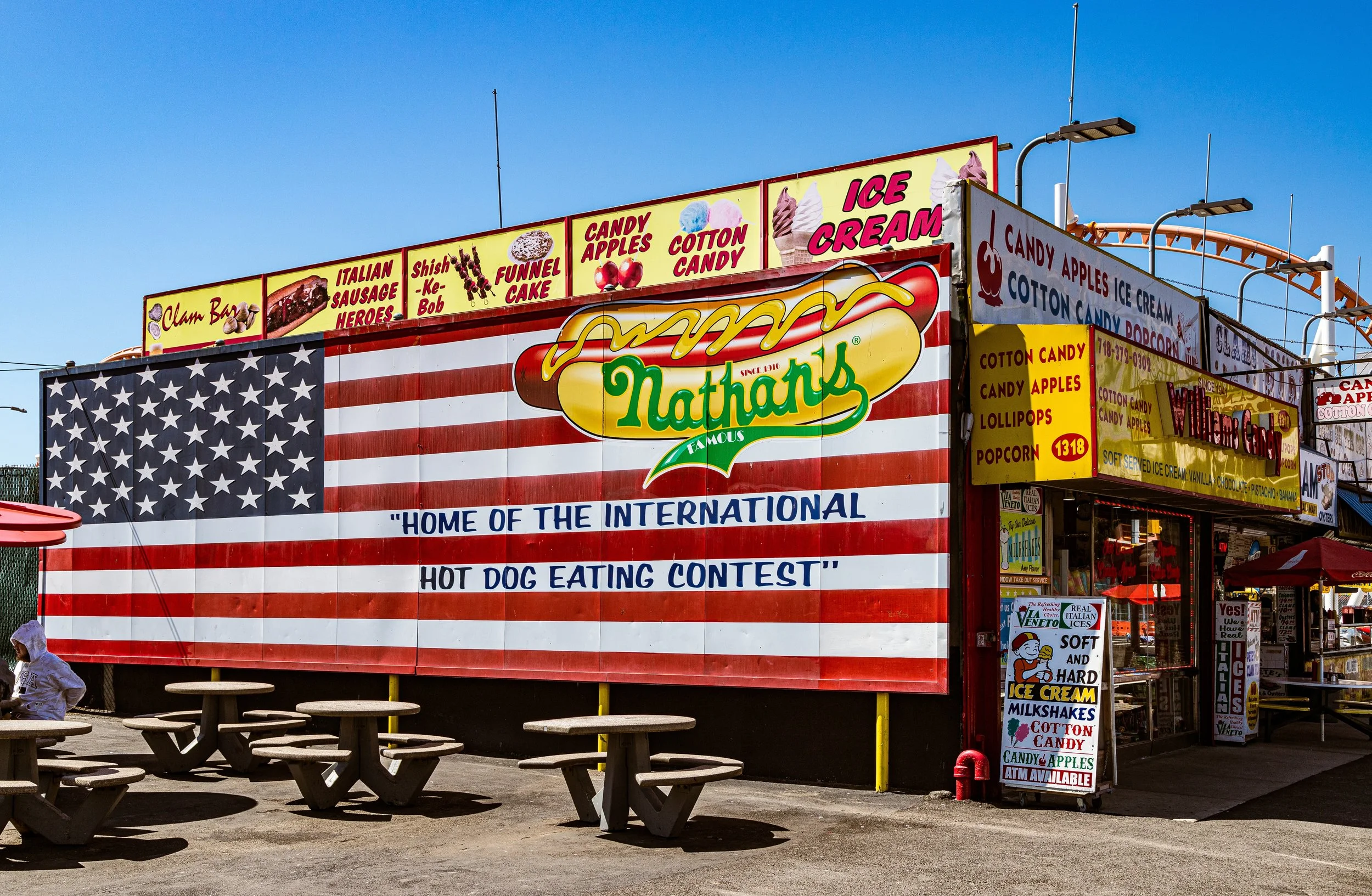
Coney Island was the first place where electricity met spectacle. The “Electric Tower” of Luna Park glowed with over 250,000 bulbs—a marvel of the modern age. The Parachute Jump, the Ferris Wheel, and the Cyclone Roller Coaster became icons of joy and vertigo. It was here that Americans first encountered many staples of popular culture: the hot dog (invented by Charles Feltman in the 1870s, perfected by Nathan’s Famous in 1916), the carousel, the midway, and the boardwalk itself.
Early–Mid 20th Century: The People’s Playground
Through the early 20th century, Coney Island was synonymous with summer in New York. Crowds exceeding a million packed its beaches on sweltering weekends, carried by the BMT subway line that reached Stillwell Avenue in 1920. The Riegelmann Boardwalk, completed in 1923, unified the shore from Sea Gate to Brighton Beach—a democratic promenade stretching for miles.
The interwar years marked the height of Coney Island’s fame. Steeplechase Park, Luna Park, and Dreamland vied for attention with roller coasters, sideshows, and spectacle rides that defied imagination. Photographers and filmmakers from Weegee to Walker Evans captured the human carnival of its beaches: lovers, bathers, hustlers, and dreamers.
But Coney Island’s appeal was not only leisure—it was freedom. Immigrants and working-class families found in its sand a rare equality, a place where language, wealth, and background dissolved in salt water. In the 1930s, under the guidance of Parks Commissioner Robert Moses, new bathhouses, playgrounds, and public facilities were built, reflecting the New Deal belief in recreation as civic good.
After World War II, however, the decline of amusement culture began. Television, air conditioning, and the rise of suburban leisure drew visitors elsewhere. Fires destroyed sections of Luna Park (1944) and Steeplechase (1964), and the once-glittering boardwalk fell into disrepair. Urban renewal projects replaced amusements with high-rise housing, including the Warbasse Houses (1966) and the Coney Island Houses (1956). Yet through it all, the neighborhood’s spirit endured—embodied by the laughter of children on the beach, the defiance of the Polar Bear Club, and the enduring scent of Nathan’s hot dogs along Surf Avenue.
Neighborhood Video Coming Soon
Late 20th Century: Survival and Struggle
The 1970s–1990s were years of both hardship and resilience. Crime, neglect, and poverty weighed heavily on Coney Island’s residents, even as its mythic identity persisted in the imagination. The Astroland Amusement Park (opened 1962) kept the dream alive, introducing space-age rides like the Astro Tower beside the beloved Cyclone, which was landmarked in 1988. The beachfront housing developments, though plagued by disinvestment, remained home to a strong, diverse working-class community—Caribbean, Russian, Italian, Jewish, and Latino families living side by side.
Local activism became the key to preservation. The Coney Island Chamber of Commerce, Mermaid Parade (founded 1983), and numerous neighborhood coalitions worked to revive civic pride and tourism. Artists and performers reclaimed Coney Island’s eccentricity as virtue. The Coney Island Museum (1980) and Sideshows by the Seashore reinterpreted its carnival past through irony, performance, and art, while residents fought for affordable housing, restored parks, and cleaner beaches.
By the 1990s, Coney Island was once again drawing millions each summer—not as a relic, but as a living palimpsest of New York’s resilience.
21st Century: Revival by the Sea
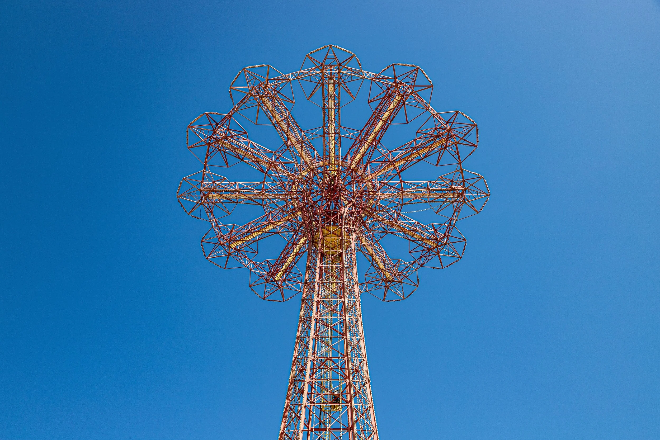
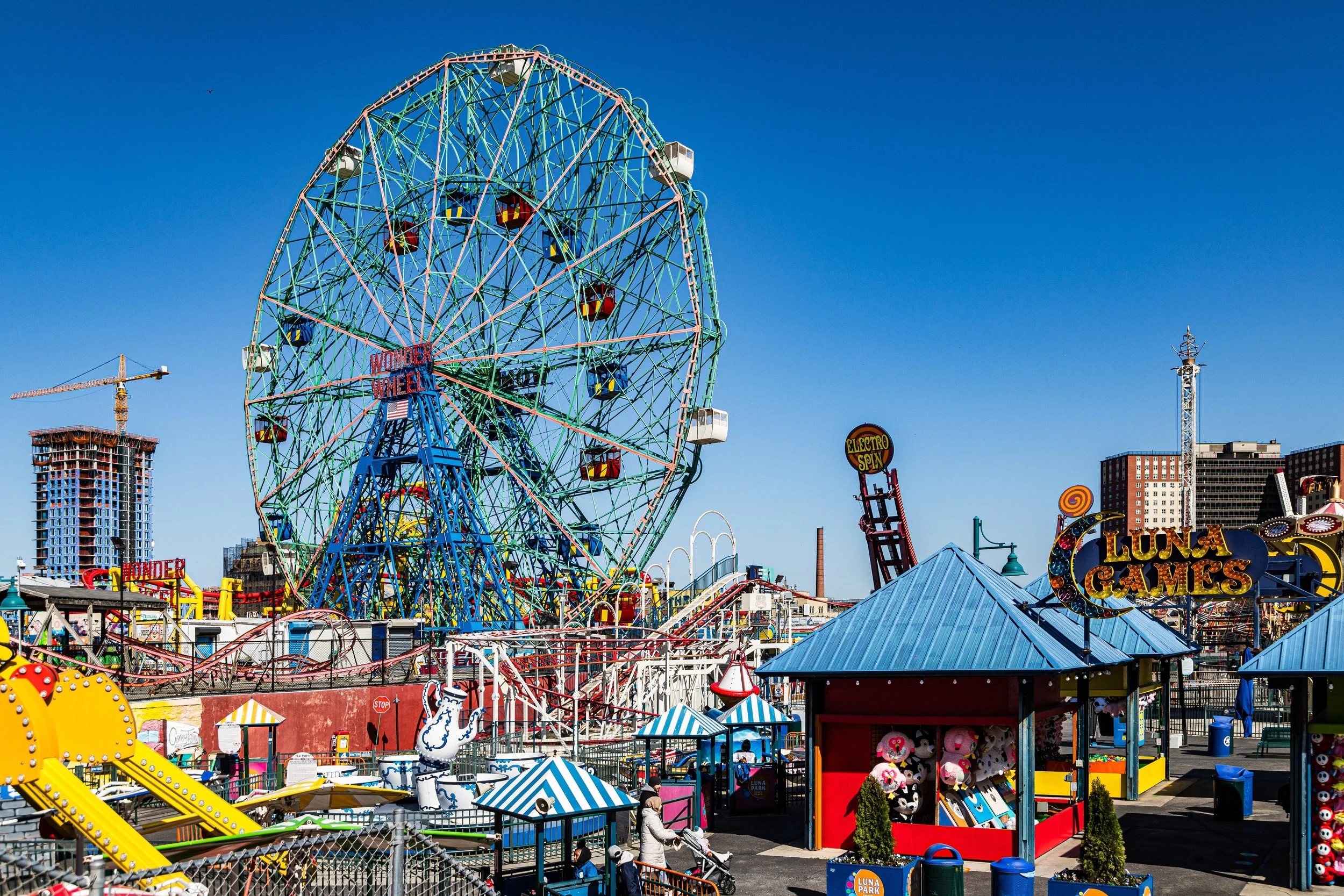
The new century brought waves of reinvestment and renewal. Coney Island’s Luna Park, resurrected in 2010 on the historic site of its namesake, reignited the spirit of the old amusement parks, introducing new rides while preserving icons like the Wonder Wheel (1920) and Cyclone. The Coney Island Amphitheater (2016) and Steeplechase Plaza brought concerts and public art to the waterfront, while the Parachute Jump, restored as a glowing nighttime beacon, reclaimed its place as the neighborhood’s emblem.
Beyond tourism, Coney Island remains a home—a resilient coastal community of more than 50,000 residents. Its public schools, small shops, and community gardens coexist beside neon arcades and surf clubs. The Coney Island Creek Park restoration project, initiated in the 2010s, reflects a growing awareness of the area’s environmental fragility amid rising seas. After Hurricane Sandy (2012), which devastated homes and businesses, residents rebuilt with a renewed sense of purpose, balancing tradition and adaptation.
The neighborhood’s streets remain filled with contradiction: the roar of roller coasters beside the cries of seagulls, the glitter of LED lights against a century-old skyline of aging brick. Yet this very tension is what defines Coney Island—it is the eternal edge, where New York looks out upon infinity and dreams.
Coney Island Photo Gallery
Spirit and Legacy
Coney Island’s legacy is nothing less than the story of American imagination itself. It is a place where innovation met the ocean, where electricity and wonder converged, and where generations of New Yorkers have come to escape, to belong, to see, and to be seen. From Feltman’s hot dogs to Luna Park’s lights, from immigrant families in wool swimsuits to the annual Mermaid Parade’s sequined surrealism, it has always reflected the city’s soul—vulgar, beautiful, restless, alive.
New York City
Use this custom Google map to explore where every neighborhood in all five boroughs of New York City is located.
The Five Boroughs
One of New York City’s unique qualities is its organization in to 5 boroughs: Manhattan, Brooklyn, Queens, The Bronx, and Staten Island. These boroughs are part pragmatic administrative districts, and part vestiges of the region’s past. Each borough is an entire county in New York State - in fact, Brooklyn is, officially, Kings County, while Staten Island is, officially Richmond County. But that’s not the whole story …
Initially, New York City was located on the southern tip of Manhattan (now the Financial District) that was once the Dutch colony of New Amsterdam. Across the East River, another city was rising: Brooklyn. In time, the city planners realized that unification between the rapidly rising cities would create commercial and industrial opportunities - through streamlined administration of the region.
So powerful was the pull of unification between New York and Brooklyn that three more counties were pulled into the unification: The Bronx, Queens, and Staten Island. And on January 1, 1898, the City of New York unified two cities and three counties into one Greater City of New York - containing the five boroughs we know today.
But because each borough developed differently and distinctly until unification, their neighborhoods likewise uniquely developed. Today, there are nearly 390 neighborhoods, each with their own histories, cultures, cuisines, and personalities - and each with residents who are fiercely proud of their corner of The Big Apple.


