MARBLE HILL
Manhattan
Geographic Setting
Uniquely situated on the mainland north of the Harlem River yet legally part of Manhattan, Marble Hill stands as one of New York City’s most curious geographic paradoxes — a fragment of the island that is no longer an island. Surrounded by The Bronx to the west (Johnson Avenue), north (West 230th Street), and east (Broadway), Marble Hill is separated from the island of Manhattan by Spuyten Duyvil Creek to the south. Here, this small residential enclave lies just across the bridge from Inwood and Kingsbridge. Its modest footprint — only a few dozen blocks — belies a history that encapsulates the story of Manhattan’s physical reshaping: from glacial rock to cut-stone quarries, from river bend to engineered canal.
Etymology and Origins
The name Marble Hill derives from the Inwood Marble, a hard, white metamorphic stone that underlies the northern tip of Manhattan and much of the Bronx. In the early 19th century, quarries along Spuyten Duyvil Creek mined this marble for building material, supplying stone for city landmarks including St. Patrick’s Cathedral and New York University’s original Gothic buildings in Washington Square. The hill upon which the neighborhood stands — once a true rise above the creek — took its name from this industry, embodying both its material wealth and its defining geology.
Before colonization, the area was part of the Lenape territory known as Shorakapok, the same region encompassing nearby Inwood Hill. The land’s abundance of fresh water and proximity to the Hudson made it a favored settlement and fishing ground.
The Neighborhood
17th–18th Centuries: Frontier and Farmland
In the Dutch colonial era, this area marked the northern frontier of Nieuw Haarlem. The marshes and meadows along Spuyten Duyvil Creek — whose name, meaning “Devil’s Spout,” referred to its dangerous tides — formed a natural barrier between Manhattan and the mainland.
By the 1700s, the land that would become Marble Hill was part of the Dyckman and Nagel family estates. Small farms, orchards, and grazing fields occupied the gentle slopes above the creek. During the American Revolution, the nearby ridges of Inwood and Spuyten Duyvil were heavily fortified, and Marble Hill’s elevation made it a vantage point in the Battle of Fort Washington in 1776.
19th Century: The Cutting of the Canal
The defining transformation came in the late 19th century with the city’s great engineering works. As New York’s maritime traffic grew, the narrow, meandering Spuyten Duyvil Creek proved inadequate for modern shipping. In 1895, the U.S. Army Corps of Engineers completed the Harlem River Ship Canal, cutting through the base of Manhattan from Kingsbridge to the Harlem River, creating a direct navigable link between the Hudson and the East River.
This monumental feat effectively severed the northern tip of Manhattan from the rest of the island. The once-contiguous neighborhood, still officially part of the borough of Manhattan, became a literal island — surrounded by water on all sides.
The final act came in 1914, when the original creek to the south was filled in. This attached Marble Hill to the Bronx mainland permanently, leaving it an island no longer — but an anomaly in jurisdiction, a piece of Manhattan surrounded entirely by the Bronx.
Early 20th Century: Urbanization and Identity
With the completion of the IRT Broadway–Seventh Avenue Subway in 1906 and the construction of the Marble Hill–225th Street Station, the area began to urbanize rapidly. Rowhouses, apartment buildings, and small commercial blocks replaced farmland. The neighborhood’s first major residential development, Marble Hill Houses, opened in 1952 as part of the New York City Housing Authority’s postwar expansion, providing homes for thousands of families and defining much of the local skyline to this day.
Marble Hill developed the social character of a small-town community within the metropolis. Its main thoroughfares — Broadway, Exterior Street, and West 225th Street — became the anchors of daily life, while local churches, playgrounds, and schools reinforced its neighborhood cohesion.
Despite its Bronx surroundings, residents remained fiercely aware of their Manhattan identity. The neighborhood’s mailing addresses, voting districts, and political representation all remained tied to Manhattan — a quirk that continues to this day. “Marble Hill,” one local saying goes, “is Manhattan with a Bronx view.”

Marble Hill Photographic Tour

Mid-20th Century: A Community Between Worlds
By the mid-20th century, Marble Hill was a working- and middle-class neighborhood defined by stability and tight-knit families. Its population reflected the broader mosaic of New York — Irish, Italian, Jewish, Puerto Rican, and African-American residents living side by side in modest brick buildings and public housing.
The construction of the Major Deegan Expressway in the 1950s reshaped its eastern edge, linking the area more closely to the Bronx than to Manhattan. Yet the community retained its distinctive geography and identity. From the top of Marble Hill’s rise, one could still trace the faint depression where the old creek had flowed — a ghost of the island it once was.
Late 20th Century: Challenges and Continuity
Like much of the Bronx and northern Manhattan, Marble Hill faced challenges in the 1970s and 1980s. Economic decline, arson, and disinvestment affected surrounding neighborhoods, though Marble Hill itself weathered the period with relative resilience. The Marble Hill Houses remained a strong community, bolstered by tenant associations and city investment.
During this time, the neighborhood’s multicultural identity deepened. Dominican and West Indian families joined long-established residents, while local businesses along Broadway reflected the city’s evolving diversity. Despite its small size, Marble Hill maintained a sense of continuity — neither affluent nor transient, but rooted in working-class pride.
21st Century: Rediscovery and Reflection
In the 21st century, Marble Hill stands as both anomaly and archetype — a microcosm of New York’s complexity. Rising property values in nearby Inwood and Riverdale have brought renewed attention to the area, yet it remains one of Manhattan’s most affordable corners. Community initiatives, improved transit connections, and park restorations — notably the Harlem River Greenway and nearby Inwood Hill Park — have enhanced its livability while preserving its unpretentious character.
Geographically, Marble Hill continues to intrigue historians and cartographers alike. Its peculiar status as the only portion of Manhattan physically separated from the island endures as a civic curiosity — a living reminder of the city’s ceaseless transformation of land and water.
Marble Hill Photo Gallery
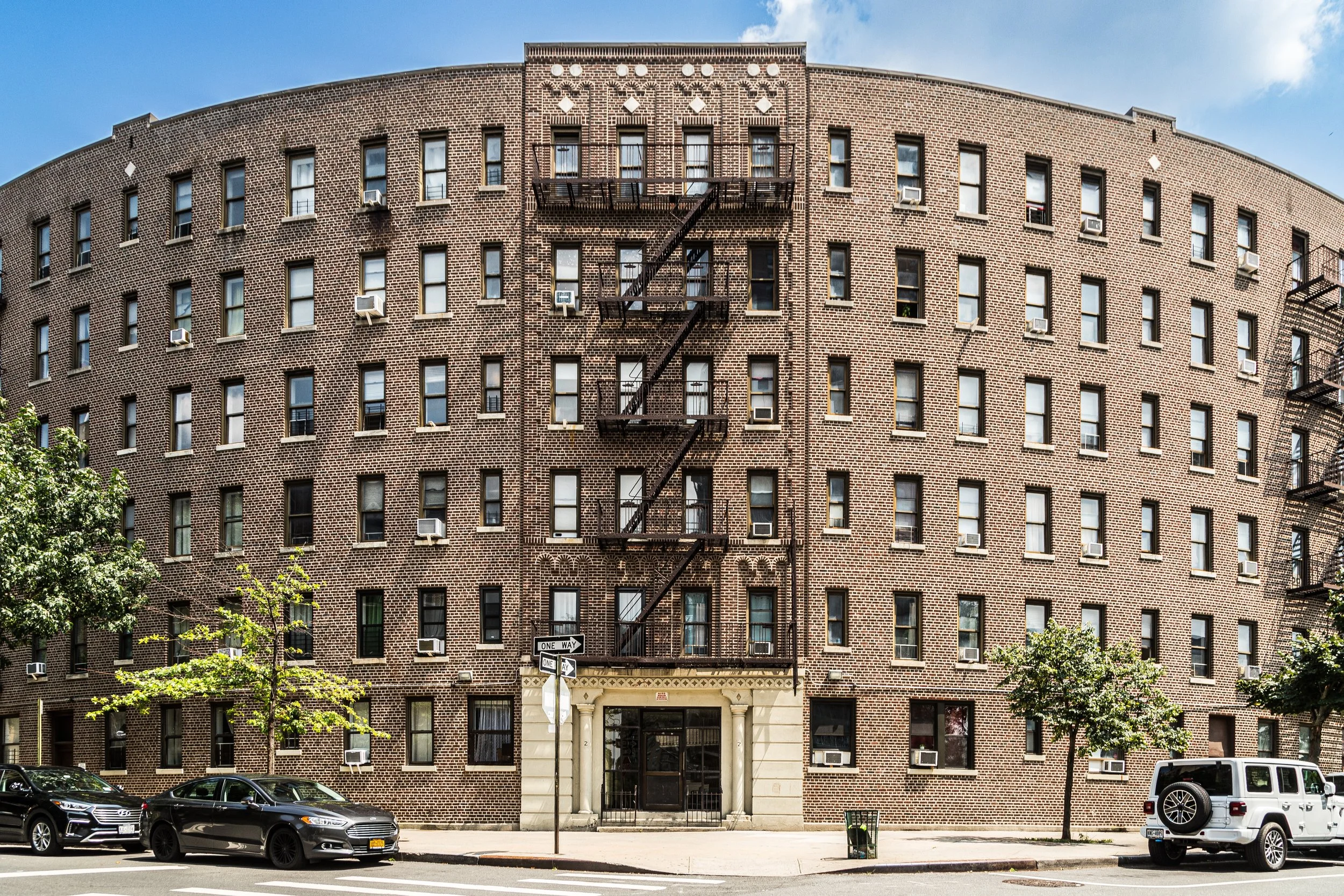
Architecture and Atmosphere
Architecturally, Marble Hill reflects the modest but enduring charm of mid-20th-century New York. Rows of red-brick apartment houses and walk-ups line its gentle slopes, interspersed with playgrounds and patches of green. The Marble Hill Houses, with their open courtyards and mature trees, form the neighborhood’s visual anchor, while older prewar buildings along Broadway recall the area’s early urbanization.
The atmosphere is intimate and grounded. Children play on stoops; neighbors greet one another across courtyards; the elevated train rumbles overhead. From the pedestrian bridge at 225th Street, one can look south to Inwood Hill Park and north to the Bronx — a panorama that encapsulates the city’s seamless blend of boroughs and histories.
Spirit and Legacy
Marble Hill’s legacy is one of paradox and perseverance. It is Manhattan’s smallest and strangest neighborhood — a community uprooted and reattached, both island and mainland, both city center and frontier. Its story embodies the ingenuity that reshaped New York’s geography and the steadfastness of the people who have made it home through every era of change.

New York City
Use this custom Google map to explore where every neighborhood in all five boroughs of New York City is located.
The Five Boroughs
One of New York City’s unique qualities is its organization in to 5 boroughs: Manhattan, Brooklyn, Queens, The Bronx, and Staten Island. These boroughs are part pragmatic administrative districts, and part vestiges of the region’s past. Each borough is an entire county in New York State - in fact, Brooklyn is, officially, Kings County, while Staten Island is, officially Richmond County. But that’s not the whole story …
Initially, New York City was located on the southern tip of Manhattan (now the Financial District) that was once the Dutch colony of New Amsterdam. Across the East River, another city was rising: Brooklyn. In time, the city planners realized that unification between the rapidly rising cities would create commercial and industrial opportunities - through streamlined administration of the region.
So powerful was the pull of unification between New York and Brooklyn that three more counties were pulled into the unification: The Bronx, Queens, and Staten Island. And on January 1, 1898, the City of New York unified two cities and three counties into one Greater City of New York - containing the five boroughs we know today.
But because each borough developed differently and distinctly until unification, their neighborhoods likewise uniquely developed. Today, there are nearly 390 neighborhoods, each with their own histories, cultures, cuisines, and personalities - and each with residents who are fiercely proud of their corner of The Big Apple.


