GOVERNORS ISLAND
Manhattan
Geographic Setting
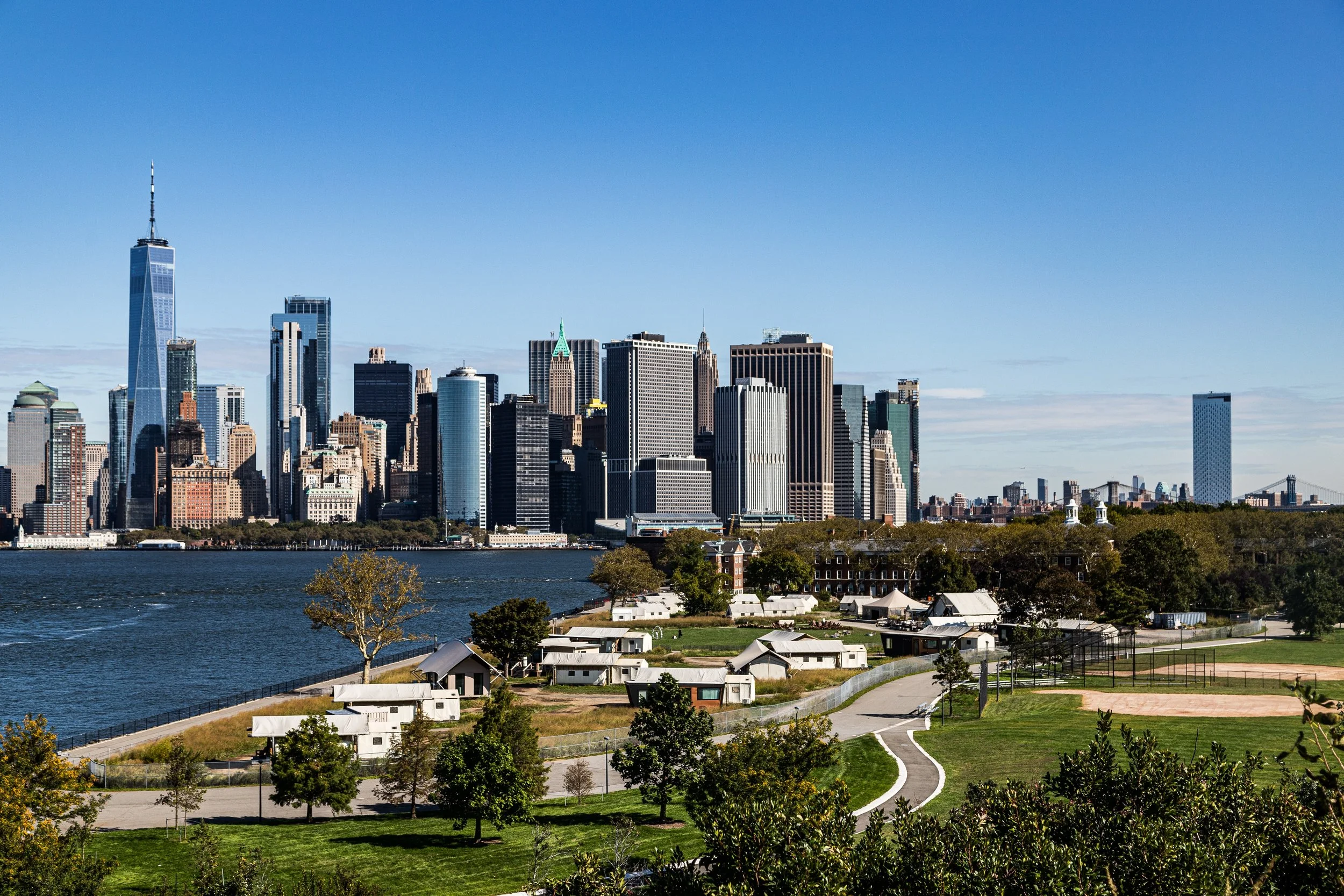
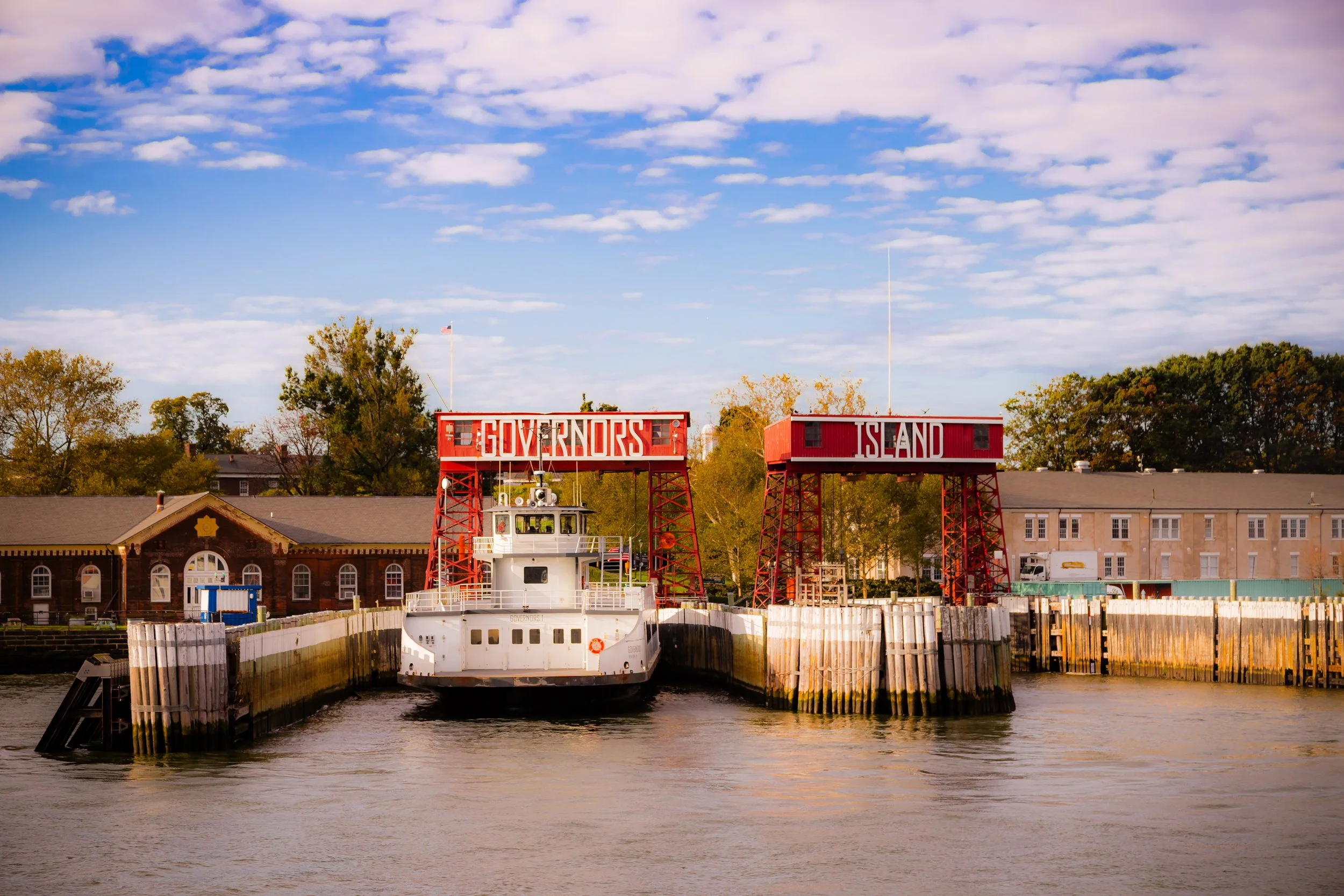
Set in the middle of New York Harbor, just 800 yards south of Manhattan, Governors Island is a green, windswept oasis steeped in four centuries of history. Encompassing 172 acres between the Brooklyn waterfront and the Battery, the island sits at the meeting point of the Hudson and East Rivers, commanding panoramic views of the Statue of Liberty, Lower Manhattan, and the Verrazzano-Narrows Bridge. Accessible today by a brief ferry ride, it is both apart from and essential to the story of New York — a place where the city’s military past, civic imagination, and ecological renewal converge.
Etymology and Origins
The island’s name dates to 1698, when Britain’s colonial administration designated it “Governors Island” as a residence for the royal governors of New York. Yet its history reaches far deeper. For the Lenape people, who called it Pagganck (“nut island”) for its abundance of hickory and chestnut trees, the island was part of a broader maritime landscape of seasonal fishing and gathering grounds across the harbor.
In 1624, Dutch settlers established a small outpost here — one of the earliest in the New World — using the island as a defensive and agricultural foothold for New Amsterdam. From its shores, they surveyed the harbor that would one day become the world’s greatest port.
The Neighborhood
17th–18th Centuries: Colonial Outpost and Revolutionary Stronghold
During the colonial period, Governors Island functioned primarily as a strategic military post. The British built fortifications there during the French and Indian War, recognizing its command over the harbor’s entrance.
In 1776, as the American Revolution erupted, General George Washington stationed troops on the island to defend New York against British invasion. Earthen batteries mounted with cannons lined the waterfront, and from this vantage, soldiers watched British ships advance toward the disastrous Battle of Brooklyn. After the Continental Army’s retreat, the British seized and held the island for the duration of the war.
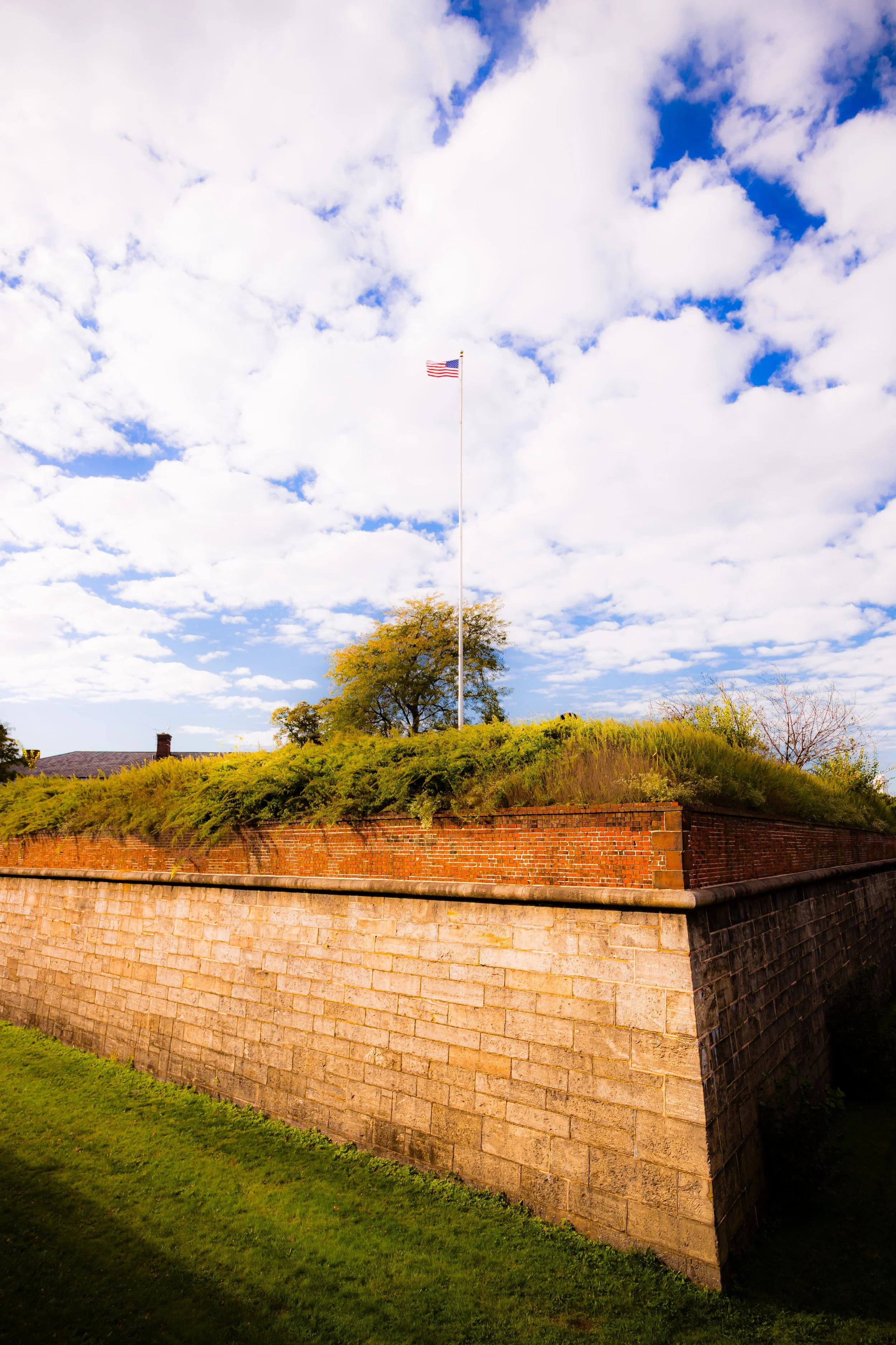
Following independence, the new United States recognized the island’s enduring importance. In 1794, amid rising tensions with France, the government began constructing a permanent harbor defense system. Two masonry forts — Fort Jay (1794–1809) and Castle Williams (1807–1811) — soon rose from the island’s bluffs. Together, they became part of the “First System” of American coastal fortifications, guarding New York from foreign attack during the War of 1812.
19th Century: Fortress and Community
Throughout the 19th century, Governors Island evolved from fortress to full military community. Fort Jay served as a command center, while Castle Williams — a circular bastion of red sandstone — was converted into a military prison by mid-century.
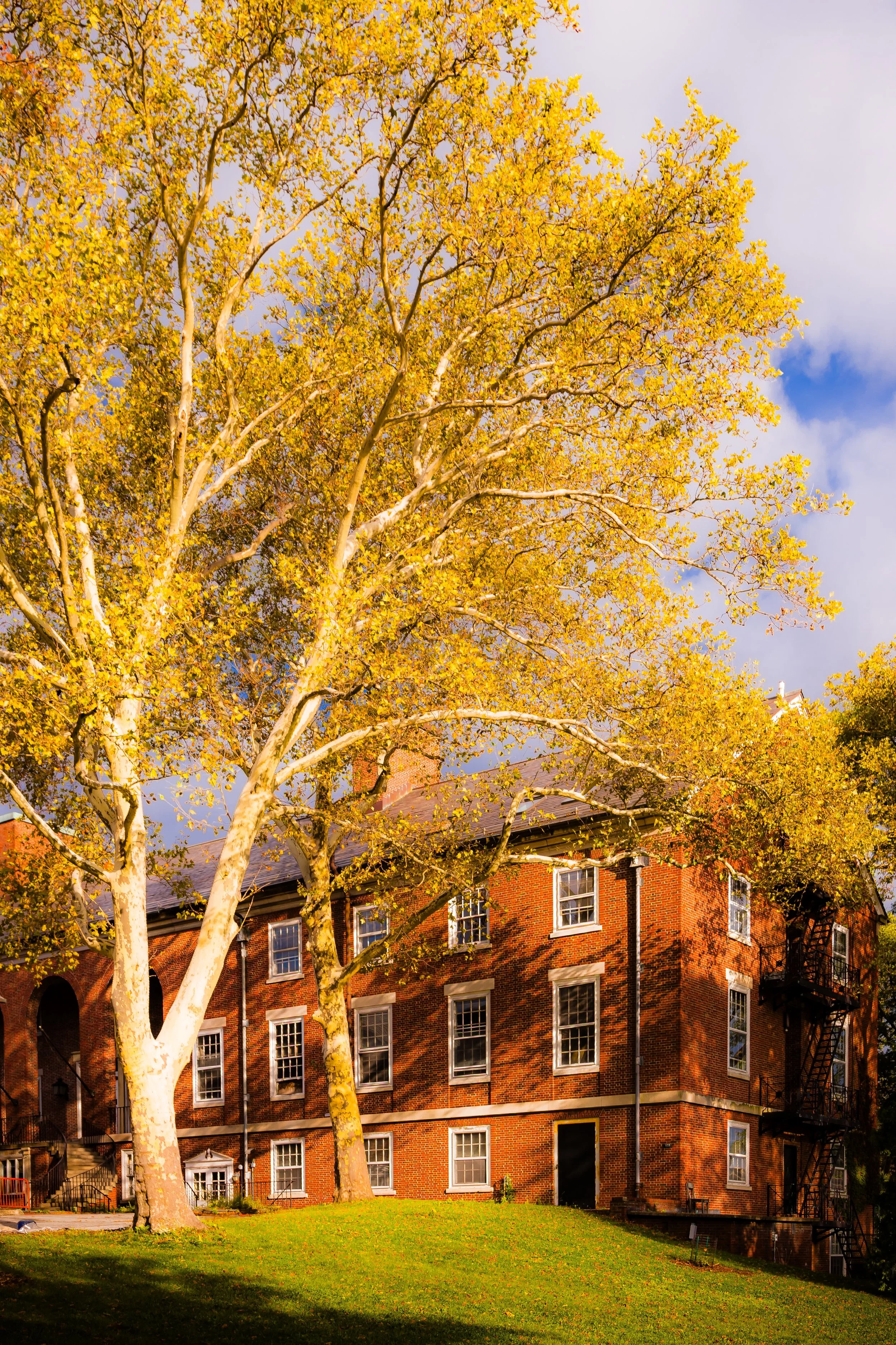
In 1821, the island officially became a U.S. Army post known as Fort Columbus (later restored to its original name, Fort Jay). Families, officers, and enlisted men lived side by side in a small but vibrant enclave, complete with a chapel, parade ground, and tree-lined officers’ quarters known as Colonels’ Row. The rhythmic order of military life — drills, ceremonies, and cannon salutes — gave the island its distinctive cadence.
The Army continually expanded the island by landfill; by the late 1800s, its acreage had nearly doubled. Steam ferries connected it to Manhattan, and its manicured lawns contrasted sharply with the industrial bustle across the harbor.
Early 20th Century: Arsenal of the Empire City
During the Spanish-American War (1898) and both World Wars, Governors Island served as the headquarters for the Army’s Eastern Defense Command. Its role was administrative rather than combative, but strategically crucial — coordinating troop movements, coastal defenses, and logistics for the entire Atlantic seaboard.
Architecturally, the island flourished during this era. The McKim, Mead & White–designed Commanding Officers’ Quarters, Georgian Revival barracks, and red-brick administrative buildings reflected the confident civic style of early 20th-century America. The skyline of Lower Manhattan, visible just across the water, provided a daily reminder that this was the military front porch of the nation’s greatest city.
In 1939, the island hosted the Army’s pageantry for the World’s Fair and later became a major point of departure for troops during World War II. Yet even amid its strategic importance, the island retained an almost pastoral atmosphere: children playing beneath oaks, officers’ families tending gardens, and ferries gliding through the harbor mist.
Governor’s Island Video Coming Soon
Mid-20th Century: Cold War Command and Transition
After World War II, Governors Island continued as a vital command center. In 1966, the U.S. Army left, and the island was transferred to the U.S. Coast Guard, which made it the largest Coast Guard base in the world. The service operated its Atlantic headquarters, training schools, and housing for nearly 3,000 personnel and their families.
For three decades, the island functioned as a self-contained village — complete with a school, movie theater, hospital, and church. Yet by the 1990s, budget cuts and changing defense priorities rendered it obsolete. In 1996, the Coast Guard closed the base, ending more than 200 years of continuous military presence.
21st Century: A New Civic Frontier
In 2003, Governors Island entered a new era when the federal government sold most of its land to the People of the City and State of New York for the symbolic price of $1. The northern 92 acres — including Fort Jay and Castle Williams — became a National Monument, while the southern half was slated for public use and park development.
Since then, the island has undergone a spectacular transformation. The creation of The Hills (2016) — a 43-acre landscape designed by West 8 Urban Design & Landscape Architecture — introduced sculpted topography, winding paths, and 360-degree views of the harbor. Historic buildings have been repurposed for arts, education, and sustainability projects, including the Urban Assembly New York Harbor School and the Governors Island Climate Center, a global hub for environmental research.
Today, Governors Island serves as a seasonal refuge for millions of visitors each year. Ferries from both Manhattan and Brooklyn bring pedestrians and cyclists to lawns, hammocks, art installations, and festivals. The island’s blend of historic architecture and contemporary ecology has made it one of New York’s most beloved public spaces — a laboratory for the city’s green future.
Governor’s Island Photo Gallery Coming Soon
Architecture and Atmosphere
Architecturally, Governors Island is a living timeline. The star-shaped ramparts of Fort Jay, the circular mass of Castle Williams, and the Colonial Revival homes of Colonels’ Row stand beside adaptive reuse projects that merge preservation with innovation. The soundscape shifts with the seasons: ferry horns, wind through trees, the laughter of cyclists echoing off 19th-century brick.
The atmosphere is pastoral and panoramic — the city seen from just far enough away to feel timeless. Its meadows and seawalls hold traces of cannon fire, parade marches, and children’s footsteps — centuries layered into quiet harmony.
Spirit and Legacy
Governors Island’s legacy is transformation through stewardship. Once a fortress of empire, later a village of service, and now a commons of renewal, it has mirrored the city’s evolution from defense to imagination.
New York City
Use this custom Google map to explore where every neighborhood in all five boroughs of New York City is located.
The Five Boroughs
One of New York City’s unique qualities is its organization in to 5 boroughs: Manhattan, Brooklyn, Queens, The Bronx, and Staten Island. These boroughs are part pragmatic administrative districts, and part vestiges of the region’s past. Each borough is an entire county in New York State - in fact, Brooklyn is, officially, Kings County, while Staten Island is, officially Richmond County. But that’s not the whole story …
Initially, New York City was located on the southern tip of Manhattan (now the Financial District) that was once the Dutch colony of New Amsterdam. Across the East River, another city was rising: Brooklyn. In time, the city planners realized that unification between the rapidly rising cities would create commercial and industrial opportunities - through streamlined administration of the region.
So powerful was the pull of unification between New York and Brooklyn that three more counties were pulled into the unification: The Bronx, Queens, and Staten Island. And on January 1, 1898, the City of New York unified two cities and three counties into one Greater City of New York - containing the five boroughs we know today.
But because each borough developed differently and distinctly until unification, their neighborhoods likewise uniquely developed. Today, there are nearly 390 neighborhoods, each with their own histories, cultures, cuisines, and personalities - and each with residents who are fiercely proud of their corner of The Big Apple.


