RICHMOND HILL
Queens
Neighborhood Profile
A neighborhood of "Grand Victorian" character, Richmond Hill is renowned for its stunning 19th-century frame houses and its deep cultural roots. Today, it is a vibrant center of Indo-Caribbean life, defined by the bustling commerce of Liberty Avenue, the lush greenery of Forest Park at its northern border, and a resilient, multicultural community spirit.
Geographic Setting
Bounded by Atlantic Avenue to the south, 98th Street to the west, Park Lane South to the north, Bessemer Street to the northeast, and 121st Street to the east, Richmond Hill occupies a broad, gracefully gridded expanse of central Queens—nestled between Kew Gardens to the north, Ozone Park to the south, and Woodhaven to the west. Distinguished by its Victorian architecture, tree-lined streets, and longstanding civic identity, Richmond Hill stands as one of the borough’s most architecturally cohesive and historically resonant neighborhoods.
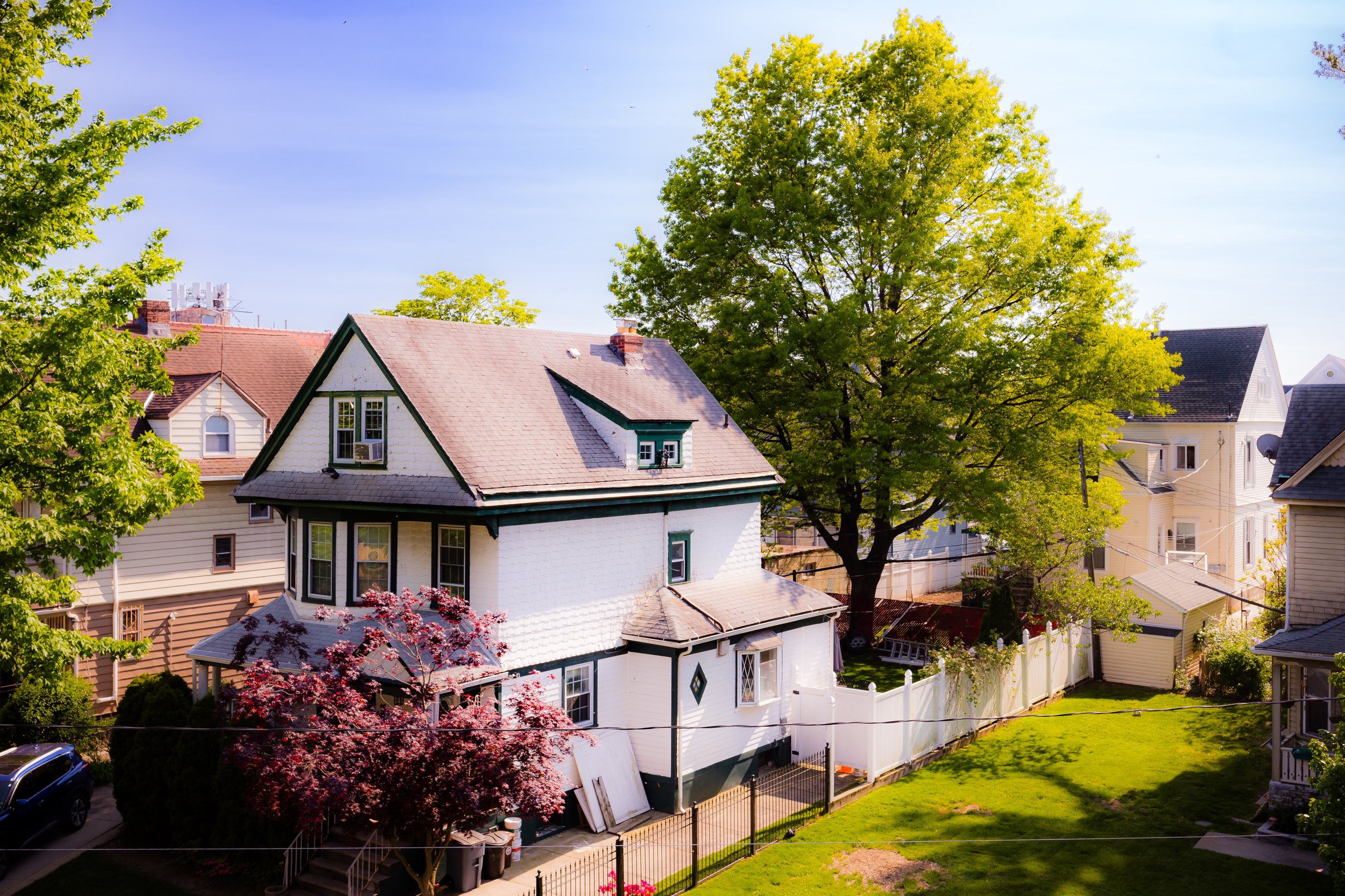
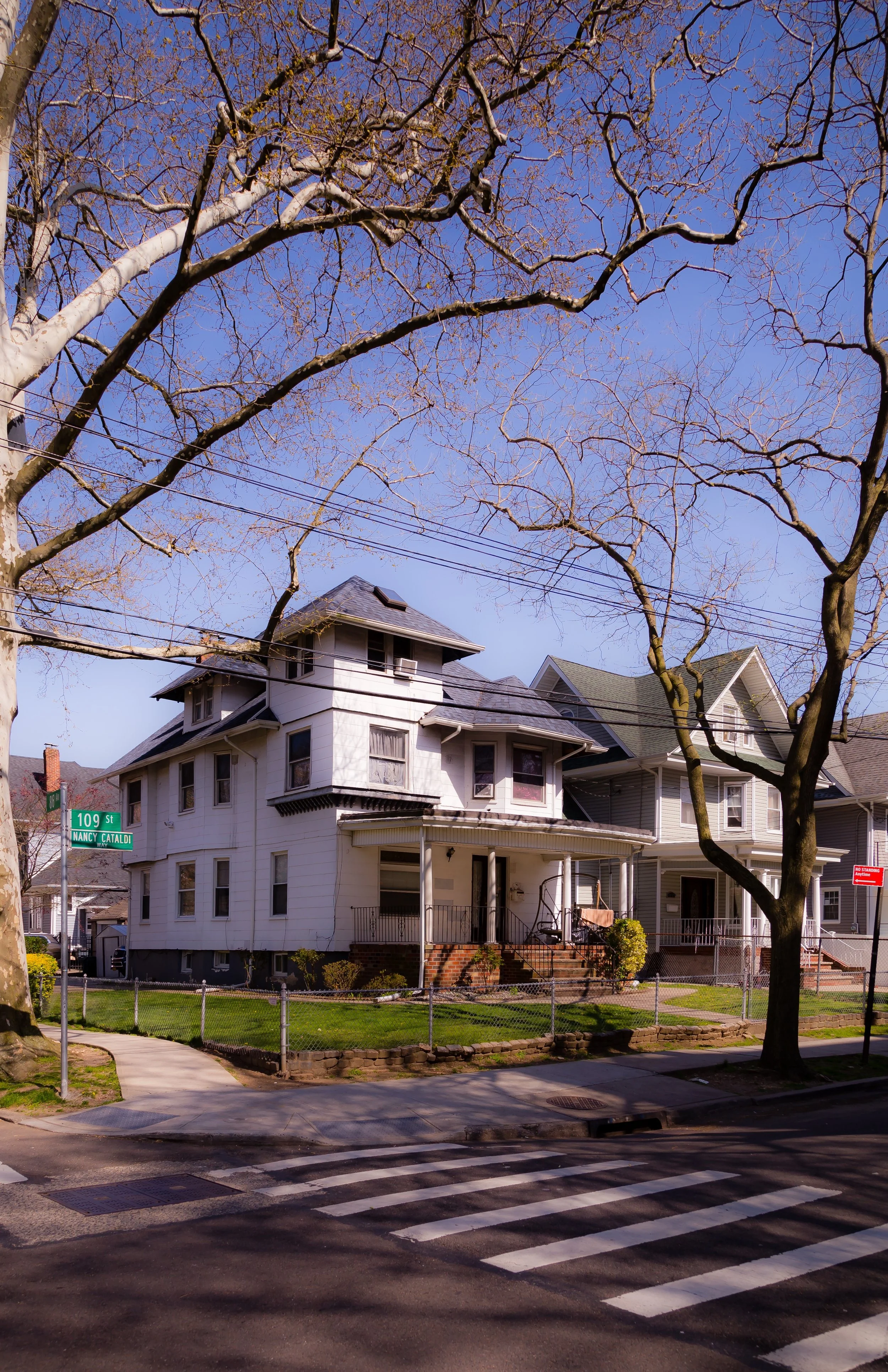
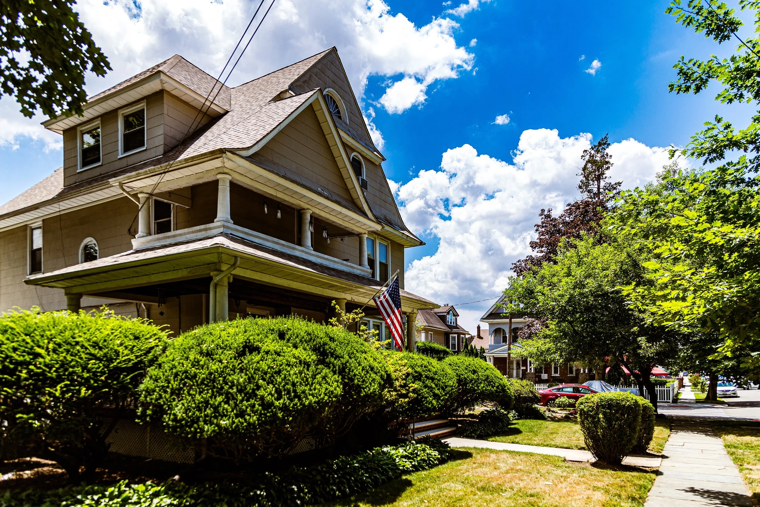
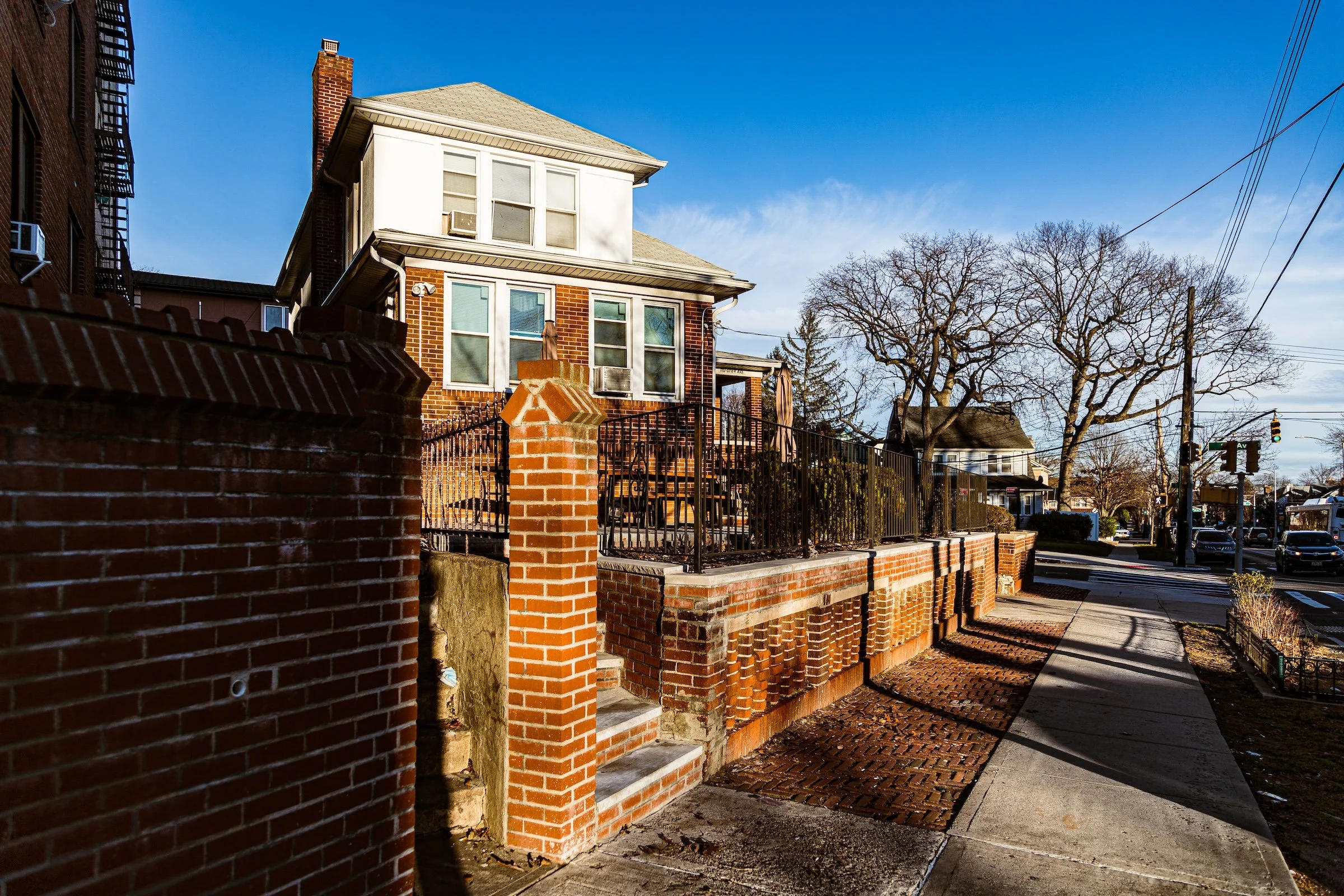
Its streets form an elegant lattice of detached frame houses, brick rowhomes, and prewar apartment buildings, many dating to the late 19th and early 20th centuries, when the area was marketed as “the garden suburb of Queens.” The commercial spine, Jamaica Avenue, cuts east–west through the heart of the neighborhood, lined with small businesses, groceries, and family-owned shops that serve a diverse, multigenerational population. Lefferts Boulevard and Atlantic Avenue further link Richmond Hill to the surrounding city, while nearby Forest Park—accessible via Park Lane South—provides a verdant northern border, anchoring the community in the borough’s greenbelt.
Today, Richmond Hill remains a distinctive mix of old and new: Queen Anne and shingle-style homes stand beside Hindu temples and Indo-Caribbean bakeries, embodying a story of transformation grounded in enduring neighborhood pride.
Etymology and Origins
The name “Richmond Hill” was chosen in 1869 by developers Albon Platt Man and Edward Richmond, who drew inspiration from the affluent London suburb of the same name. The project was conceived as a planned suburban community—an early prototype of what would later define much of Queens’ growth. Advertised as “an elevated and healthful retreat” with wide streets and ample gardens, Richmond Hill was designed for Manhattan commuters seeking semi-rural tranquility.
The land itself was once part of the Town of Jamaica, consisting of farmland and wooded tracts owned by the Lefferts and Van Wyck families. Development accelerated in the 1870s after the extension of the Long Island Rail Road’s Montauk Branch, which offered direct access to Brooklyn and Manhattan. By the turn of the century, the area had become a thriving residential enclave, known for its Victorian architecture, broad verandas, and tree-lined avenues that reflected both urban sophistication and pastoral charm.
The neighborhood’s planners placed a particular emphasis on aesthetics and livability: lots were laid out with generous setbacks, and street names—such as Lenox, Hillside, and Richmond Hill Road (now Jamaica Avenue)—evoked refinement and order.
The Neighborhood
Late 19th – Early 20th Century: The Victorian Suburb
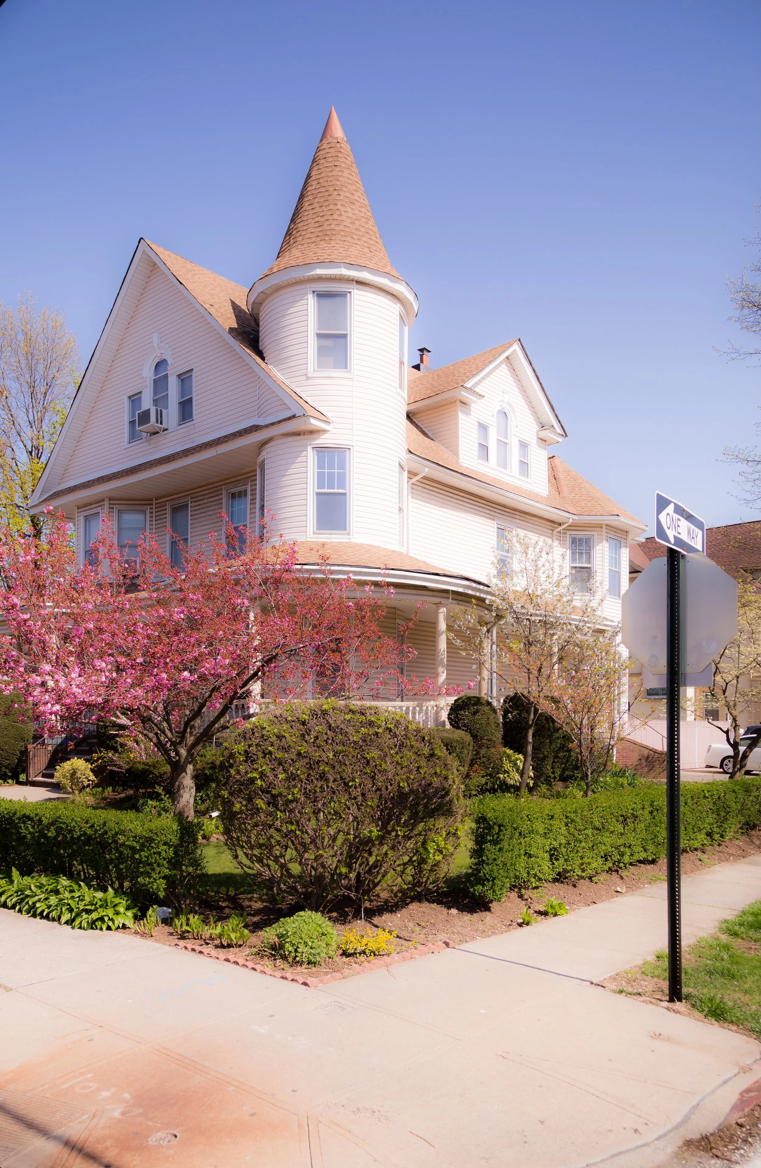
From the 1880s through the 1910s, Richmond Hill flourished as one of Queens’ premier suburban developments. Wealthy professionals, merchants, and civic leaders from Brooklyn and Manhattan built Victorian, Colonial Revival, and Queen Anne–style homes along avenues such as 114th Street, 115th Street, and Park Lane South, many of which still stand today with original woodwork, stained glass, and wraparound porches.
The community’s elegant architecture was complemented by strong civic institutions. The Richmond Hill Republican Club (established 1898) became a local landmark, both politically and architecturally, while churches such as St. Benedict Joseph Labre Roman Catholic Church (1892) and Union Congregational Church anchored community life. Public schools and social organizations quickly followed, as did streetcar lines along Jamaica Avenue, which transformed the area into a vibrant yet self-contained suburb.
By the 1920s, Richmond Hill had achieved a stable, middle-class identity, defined by a blend of homeownership, civic pride, and small business enterprise. The architecture of this era—particularly the broad, freestanding houses and brick apartment courts—embodied the optimism of the outer-borough expansion.
Mid-20th Century: Cultural Continuity and Change
In the decades following World War II, Richmond Hill remained a largely German-, Irish-, Italian-, and Jewish-American enclave, notable for its tidy homes, strong parish communities, and thriving commercial strips. Jamaica Avenue was lined with department stores, bakeries, diners, and music shops, while the nearby Loew’s Willard Theater (later the RKO Alden) served as a social center for families.
The elevated J train, running above Jamaica Avenue, solidified Richmond Hill’s role as a commuter hub, while the Van Wyck Expressway and Grand Central Parkway increased regional accessibility. During the 1950s and 1960s, the neighborhood weathered urban changes that reshaped much of New York, maintaining its suburban stability through civic organizations and active homeowners’ associations.
By the 1970s and 1980s, however, demographic shifts brought new energy and complexity. Families from the Caribbean, Latin America, and South Asia began moving in, drawn by affordable housing and proximity to jobs and transportation. Over time, these newcomers—particularly Indo-Caribbean immigrants from Guyana and Trinidad—transformed Richmond Hill into one of the most dynamic centers of Caribbean and South Asian life in New York City.
Richmond Hill Photographic Video
Late 20th – 21st Century: The Indo-Caribbean Heart of Queens
By the late 20th century, Richmond Hill had become known as “Little Guyana” and “Little Trinidad,” home to one of the largest Indo-Caribbean communities in the United States. Businesses along Liberty Avenue and Lefferts Boulevard blossomed with roti shops, sari boutiques, puja supply stores, and Caribbean groceries, creating one of Queens’ most distinctive cultural corridors.
This wave of immigration reshaped not only the neighborhood’s demographics but also its visual and cultural identity. Modest frame houses were expanded with new architectural flourishes—stucco facades, domed porches, bright paintwork—while Hindu temples, mosques, and Mandirs rose alongside older churches. Annual events such as Phagwah (Holi) and Diwali celebrations now draw thousands, transforming Liberty Avenue into a vibrant pageant of color, music, and community.
At the same time, Richmond Hill’s Victorian core—particularly its northern section near Park Lane South—has seen renewed preservation efforts. The Richmond Hill Historical Society, founded in 1999, works to protect and promote the neighborhood’s unique architectural heritage, cataloging its late 19th-century homes and civic landmarks.
Despite traffic and development pressures, Richmond Hill has retained its essential identity: a diverse, family-oriented neighborhood where old and new traditions coexist in harmony.
Richmond Hill Photo Gallery
Through The Lens
The lack of foliage in January is a photographer’s gift in Richmond Hill. Without leaves to block the sun, the golden light is free to "paint" the architecture.
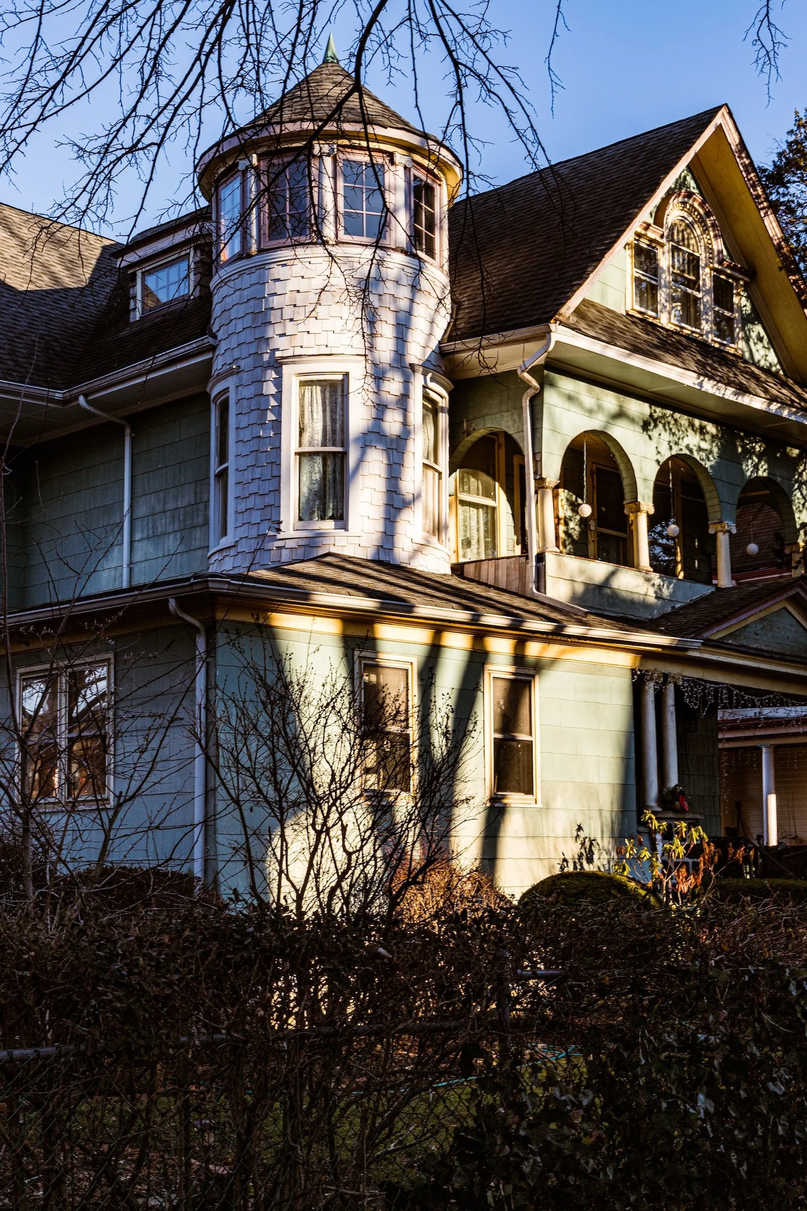
The Fairy-Tale Aesthetic: I wanted to capture the neighborhood’s story-book feel. In Shadows On Walls, the bare branches of the trees cast intricate, dark silhouettes across the pale siding of the manor. It’s a natural projection—the tree is literally drawing itself onto the house.
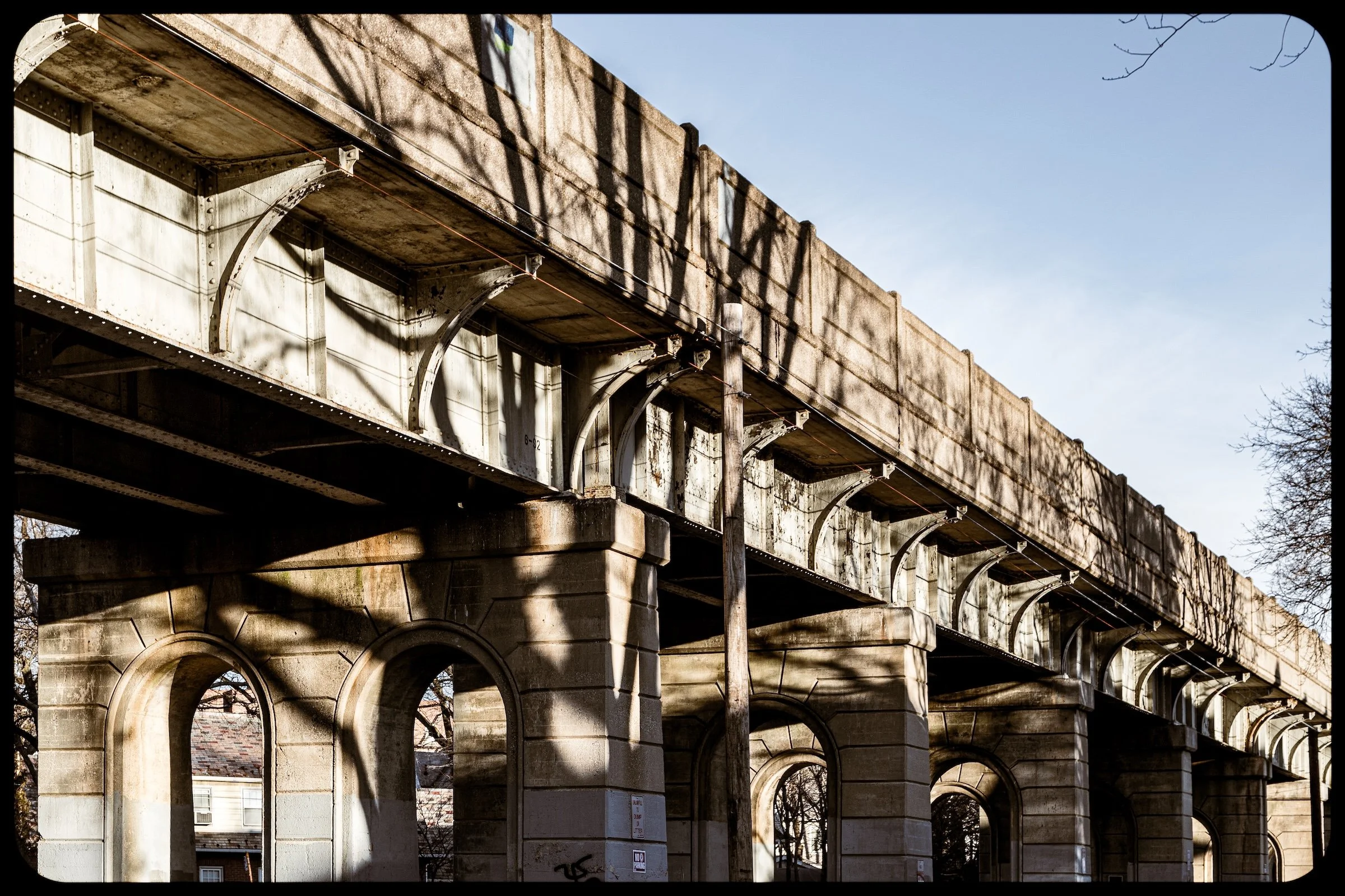
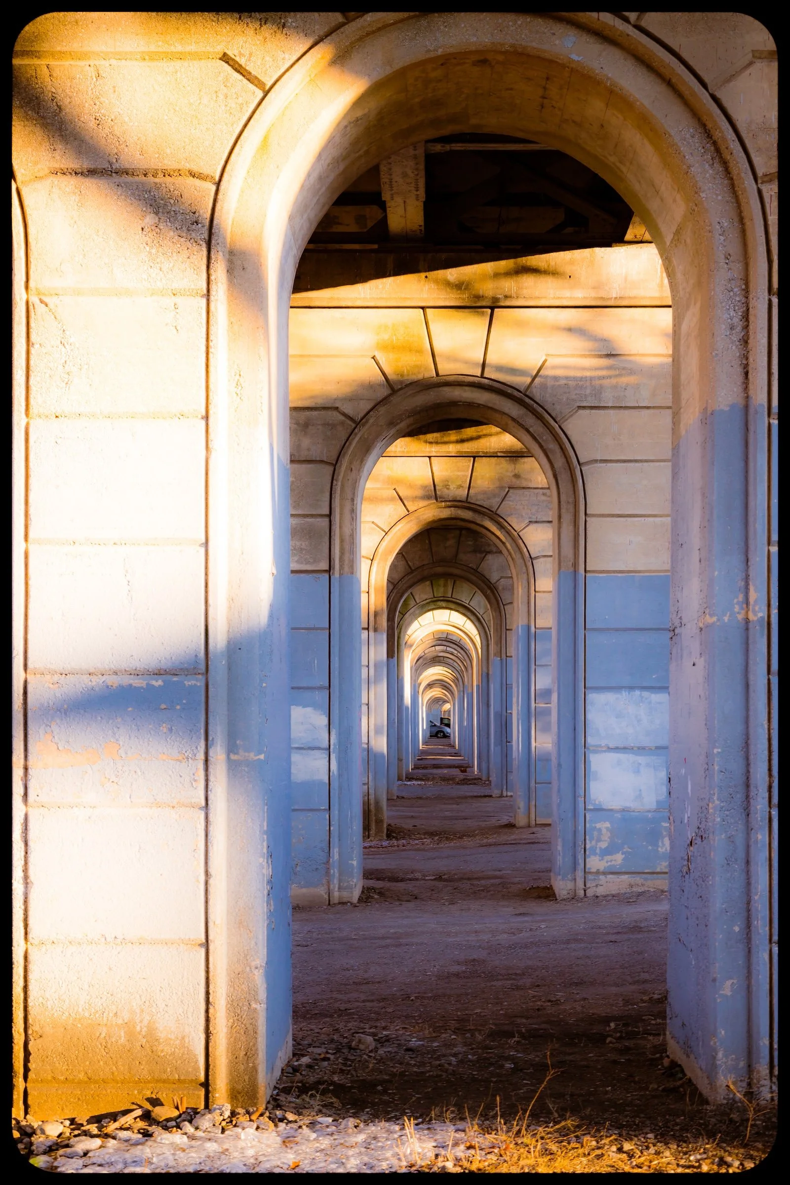
Finding the Perspective: Even "forgettable" or messy settings like the underpasses offer incredible geometric opportunities if you use the light correctly.
The Technique: In Tunnels, I used the repeating arches to create a deep vanishing point. The low sun catches only the leading edges of the concrete, highlighting the perspective and turning a dark transit corridor into a series of glowing ribs. This is the goal: using the light to find order and beauty in the industrial "mess."
Spirit and Legacy
Richmond Hill’s spirit lies in its continuity through transformation. Born as a Victorian commuter suburb, it evolved into a global crossroads—its elegant streets now filled with the rhythms, languages, and aromas of the Caribbean and South Asia. Yet beneath these layers of change, the neighborhood’s architectural grace, civic pride, and sense of belonging remain intact.
Richmond Hill Field Notes
-
January 15, 2023 | 16:49 – 16:58
Weather: 36°F (2°C) | Deep Golden Hour | Wind: 5 mph NW
Conditions: Long, dramatic shadows; heavy amber light; clear atmosphere.
Field Notes
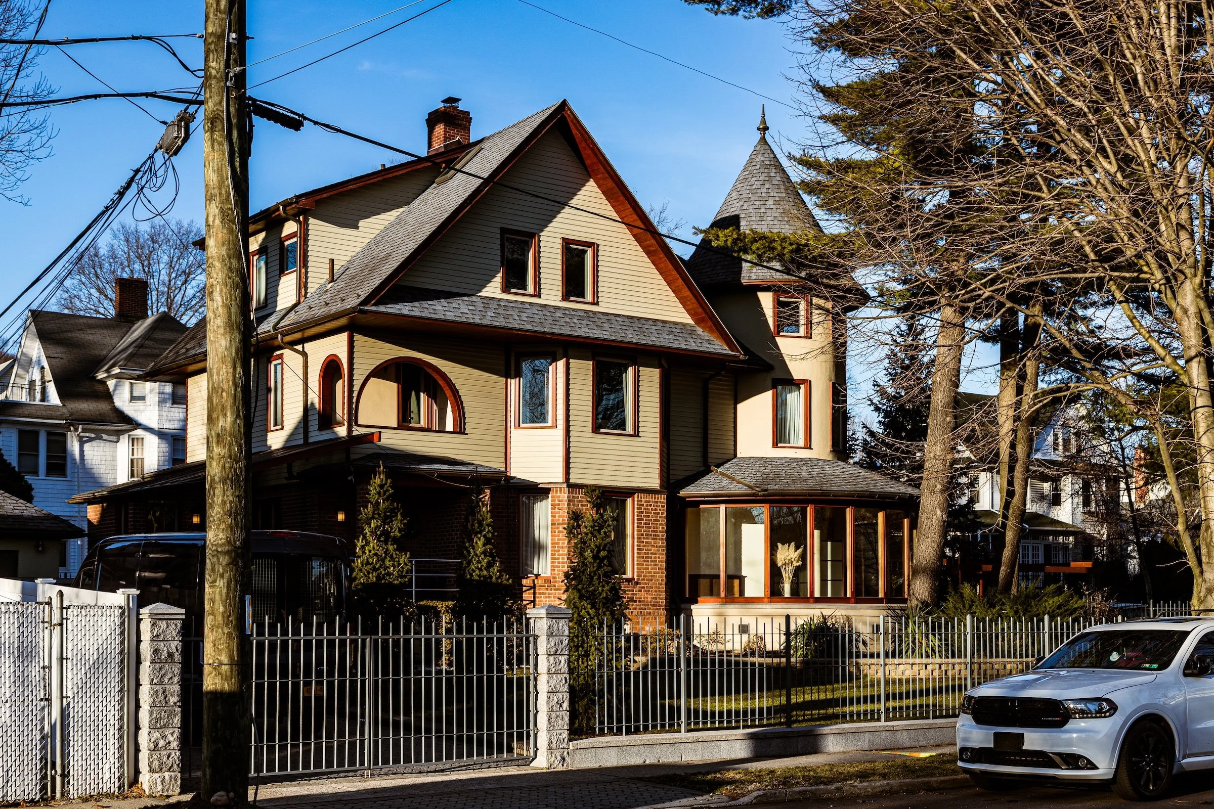
Though my time here was brief, it was perhaps the most visually "weighted" part of the day. The late-afternoon winter sun reached that peak horizontal angle where it doesn't just light a subject—it bathes it. The classic Victorian homes, like the one in Turret At 113th, took on a nostalgic, almost cinematic glow that felt completely removed from the modern city.
This warmth was punctuated by the massive, industrial presence of the freight train trellis. In Elevated Freight, the sun gave a "dramatic heft" to the concrete and steel that usually feels cold and imposing. It’s a strange harmony: the delicate, gingerbread details of the Manor Reflection contrasting against the brutalist repetition of the tracks.
Other neighborhoods visited:
Corner Lot
Elevated Freight

Manor Reflection
Shadows On Walls
Tunnels
Turret At 113th
Use this custom Google map to explore where every neighborhood in all five boroughs of New York City is located.
The Five Boroughs
One of New York City’s unique qualities is its organization in to 5 boroughs: Manhattan, Brooklyn, Queens, The Bronx, and Staten Island. These boroughs are part pragmatic administrative districts, and part vestiges of the region’s past. Each borough is an entire county in New York State - in fact, Brooklyn is, officially, Kings County, while Staten Island is, officially Richmond County. But that’s not the whole story …
Initially, New York City was located on the southern tip of Manhattan (now the Financial District) that was once the Dutch colony of New Amsterdam. Across the East River, another city was rising: Brooklyn. In time, the city planners realized that unification between the rapidly rising cities would create commercial and industrial opportunities - through streamlined administration of the region.
So powerful was the pull of unification between New York and Brooklyn that three more counties were pulled into the unification: The Bronx, Queens, and Staten Island. And on January 1, 1898, the City of New York unified two cities and three counties into one Greater City of New York - containing the five boroughs we know today.
But because each borough developed differently and distinctly until unification, their neighborhoods likewise uniquely developed. Today, there are nearly 390 neighborhoods, each with their own histories, cultures, cuisines, and personalities - and each with residents who are fiercely proud of their corner of The Big Apple.


