ATLANTIC AVENUE
Geographic Setting
Atlantic Avenue is one of New York City’s oldest and most storied thoroughfares—a 10-mile artery that cuts a straight and symbolic line across Brooklyn and Queens, from the Brooklyn waterfront at the East River to the Van Wyck Expressway near Jamaica, where it continues eastward toward Long Island. Its western terminus begins amid the historic brownstones of Brooklyn Heights and the former docks of Cobble Hill, then proceeds east through Downtown Brooklyn, Boerum Hill, Fort Greene, Prospect Heights, Crown Heights, Brownsville, and East New York, before crossing into Woodhaven, Ozone Park, and Richmond Hill in Queens.
Along its route, Atlantic Avenue embodies the shifting character of the outer boroughs: from historic brownstone districts and global markets to industrial corridors and transit spines. It connects the Brooklyn waterfront to the Jamaica commercial core, serving as both a literal and metaphorical east–west axis—uniting centuries of commerce, migration, and transformation in a single, unbroken street.
Etymology
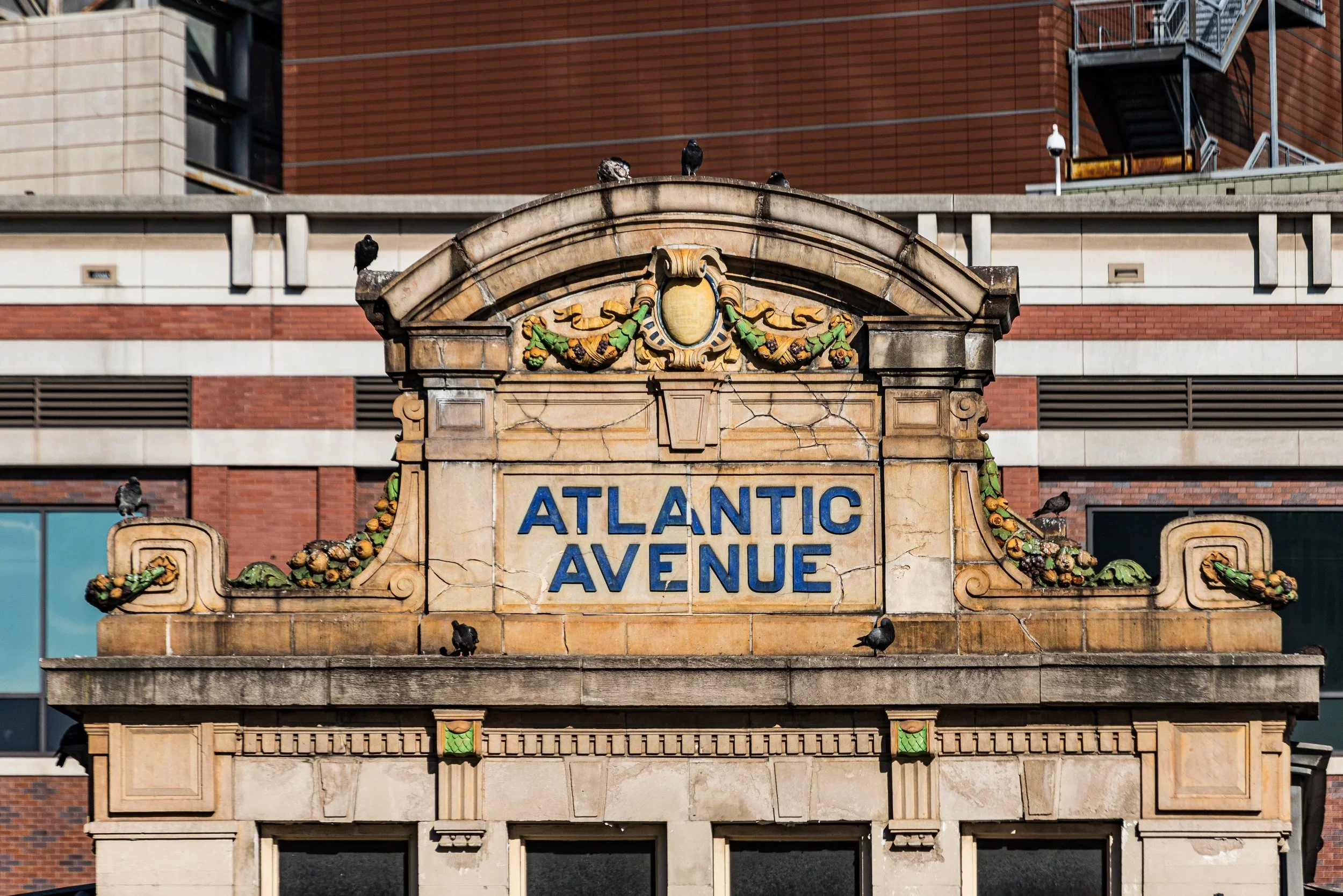
Atlantic Avenue was named in 1844, in homage to the Atlantic Ocean that it ultimately approached through its railroad and shipping connections. The name carried connotations of global commerce and maritime ambition—fitting for a street that originated as the principal access route to Atlantic Basin, one of the 19th century’s busiest ports. Earlier maps show the route as District Street and South Ferry Road, but with the rise of transatlantic shipping and the construction of the Atlantic Avenue Tunnel for the Long Island Rail Road (LIRR), the name “Atlantic Avenue” was chosen to project grandeur, modernity, and connection to the wider world.
To generations of Brooklynites, “Atlantic Avenue” became synonymous not just with geography, but with motion—where ships, trains, streetcars, and automobiles converged in an ever-evolving urban symphony.
The Avenue
Origins through the 19th Century: A Road from Harbor to Hinterland
The story of Atlantic Avenue begins in the early 19th century, when Brooklyn was still a patchwork of villages—Brooklyn Heights, Gowanus, and Bedford Corners—linked by dusty turnpikes. The segment that would become Atlantic Avenue formed part of the Brooklyn and Jamaica Turnpike, chartered in 1809, which provided farmers a route to carry produce from Long Island to the Brooklyn waterfront ferries serving Manhattan.
By the 1830s, with Brooklyn’s population booming, the Long Island Rail Road constructed its western terminus along this route, inaugurating one of the nation’s earliest commuter rail lines. In 1844, the railroad built the Atlantic Avenue Tunnel, a mile-long brick-lined passage between Boerum Place and Bedford Avenue—considered the world’s first underground railway tunnel. It allowed steam locomotives to travel safely beneath the growing neighborhoods of South Brooklyn, marking the dawn of New York’s rail age.
The opening of the Atlantic Basin in 1841, designed by visionary engineer Daniel Richards, transformed the western end of the avenue into a hub of maritime trade. Warehouses, grain elevators, and ship chandlers crowded its cobblestones, while taverns, sailors’ hotels, and immigrant boardinghouses filled the blocks beyond. To the east, the avenue stretched into farmland and open meadows, its plank road lined with stagecoach inns and wagon repair shops.
By the 1870s, horse-drawn streetcars extended along Atlantic Avenue, connecting the waterfront to East New York. The corridor became a working-class artery, serving dockhands, tradesmen, and factory workers. It was a microcosm of Brooklyn’s 19th-century transformation—from pastoral outpost to industrial powerhouse.
Early 20th Century: Commercial Convergence and Cultural Corridor
At the turn of the 20th century, Atlantic Avenue solidified its role as one of Brooklyn’s principal commercial spines. Its western reaches, anchored by the Atlantic Avenue Terminal (1892)—today’s Barclays Center and LIRR/NYC Subway hub—formed a bustling gateway between Brooklyn and Manhattan. Elevated trains and trolleys clattered overhead and at street level, linking neighborhoods from the harbor to Jamaica.
From Boerum Hill through Fort Greene and Prospect Heights, the avenue became lined with elegant warehouses, theaters, and civic buildings. Immigrant-owned businesses flourished: German butchers, Syrian grocers, Italian barbers, and Jewish delis gave the street its international flavor. The Brooklyn Academy of Music (BAM), opened nearby in 1908, established the avenue’s role as a cultural axis, a status it maintains today.
Further east, in Crown Heights and Brownsville, the avenue retained a more industrial tone—home to breweries, tanneries, and lumberyards. In East New York, it became a retail thoroughfare for new tenement communities, its storefronts catering to factory workers and new arrivals from Europe.
Crossing into Queens at Elderts Lane, the boulevard took on a more suburban aspect, running parallel to the Long Island Rail Road Atlantic Branch and providing a commercial lifeline to developing neighborhoods like Woodhaven, Ozone Park, and Richmond Hill. The avenue’s continuity across borough lines reflected the seamless urban expansion of New York in the early automobile age—a single ribbon binding Brooklyn’s brownstones to Queens’ garden suburbs.
Mid–Late 20th Century: Decline, Division, and Reinvention
The postwar decades brought turbulence to Atlantic Avenue. As industry declined and suburban flight accelerated, many of its factories and shops closed. The construction of expressways—the Brooklyn–Queens Expressway (BQE) to the north and the Van Wyck Expressway to the east—diverted through-traffic away from local streets, draining vitality from once-bustling segments.
By the 1960s, sections of Atlantic Avenue were scarred by urban renewal projects and disinvestment. The closure of the LIRR tunnel to passenger service in 1942 (reopened decades later) left the western terminus dormant, while the rise of large-scale car dealerships and warehouses changed the streetscape from pedestrian to automotive.
Yet even amid decline, Atlantic Avenue’s neighborhoods retained their identities. Boerum Hill and Cobble Hill became havens for artists and preservationists who restored brownstones and campaigned for historic district status. In Crown Heights and East New York, African American and Caribbean communities revitalized local commerce with new churches, restaurants, and markets. In Queens, particularly in Richmond Hill and Ozone Park, Indo-Caribbean, Italian, and Latin American immigrants transformed the eastern stretch into a corridor of multicultural enterprise.
By the 1980s, renewal efforts began to take hold. The Atlantic Avenue Tunnel was rediscovered by urban explorers and later recognized as a National Historic Civil Engineering Landmark. The restoration of the LIRR Atlantic Branch and the construction of the Atlantic Terminal Mall signaled a reawakening of the avenue’s western end as a transit and retail hub.
21st Century: Revitalization and the New Urban Crossroads
In the 21st century, Atlantic Avenue has reemerged as one of New York’s most dynamic urban corridors—a street of extraordinary contrasts and connections. Its western section, from Brooklyn Heights through Fort Greene, has undergone dramatic transformation. The opening of the Barclays Center in 2012 redefined the Atlantic Terminal area as a civic landmark, while surrounding blocks now blend historic rowhouses with cutting-edge architecture, restaurants, and cultural spaces.
Further east, Boerum Hill and Cobble Hill retain their brownstone charm, anchored by boutiques, Lebanese bakeries, antique shops, and bars that recall the avenue’s maritime heritage. Near BAM, new performing arts venues and luxury apartments coexist with century-old storefronts.
In Bedford-Stuyvesant and Crown Heights, Atlantic Avenue has become a frontier of reinvestment, where community institutions share space with creative studios and small manufacturers returning to once-industrial lofts. Eastward through Brownsville and East New York, the avenue remains a working-class corridor, its auto body shops, warehouses, and Caribbean eateries forming a vital local economy.
Crossing into Queens, Atlantic Avenue resumes its role as neighborhood main street. In Woodhaven and Richmond Hill, its sidewalks teem with Indo-Caribbean, Punjabi, and Latinx businesses—roti shops, sari stores, and grocery markets that give the street a distinctly global rhythm. Traffic remains heavy, but civic initiatives have sought to improve safety, widen sidewalks, and revive the avenue’s historic continuity as both commuter route and community core.
Today, the avenue’s length encapsulates the full spectrum of outer-borough life: luxury high-rises and working-class rowhouses, hip cafés and discount stores, mosques and churches, gentrification and grit—all connected by a single, enduring line of asphalt and memory.
Spirit and Legacy
The spirit of Atlantic Avenue is movement—of goods, people, and ideas across time and place. It has carried horse carts and trolleys, steam trains and subway cars, Model Ts and delivery trucks, each era imprinting its rhythm upon the street. Its legacy is one of connection: between waterfront and hinterland, between Brooklyn and Queens, between the city’s industrial past and its ever-evolving present.
Few streets contain as many layers of New York’s story. It is a street of sailors and shopkeepers, immigrants and commuters, artists and activists—a thoroughfare that has endured every reinvention without losing its pulse.
New York City
Use this custom Google map to explore where every neighborhood in all five boroughs of New York City is located.
The Five Boroughs
One of New York City’s unique qualities is its organization in to 5 boroughs: Manhattan, Brooklyn, Queens, The Bronx, and Staten Island. These boroughs are part pragmatic administrative districts, and part vestiges of the region’s past. Each borough is an entire county in New York State - in fact, Brooklyn is, officially, Kings County, while Staten Island is, officially Richmond County. But that’s not the whole story …
Initially, New York City was located on the southern tip of Manhattan (now the Financial District) that was once the Dutch colony of New Amsterdam. Across the East River, another city was rising: Brooklyn. In time, the city planners realized that unification between the rapidly rising cities would create commercial and industrial opportunities - through streamlined administration of the region.
So powerful was the pull of unification between New York and Brooklyn that three more counties were pulled into the unification: The Bronx, Queens, and Staten Island. And on January 1, 1898, the City of New York unified two cities and three counties into one Greater City of New York - containing the five boroughs we know today.
But because each borough developed differently and distinctly until unification, their neighborhoods likewise uniquely developed. Today, there are nearly 390 neighborhoods, each with their own histories, cultures, cuisines, and personalities - and each with residents who are fiercely proud of their corner of The Big Apple.
