HUDSON SQUARE
Manhattan
Geographic Setting
Bounded by Canal Street to the south, Clarkson Street to the north, Sixth Avenue to the east, and the Hudson River to the west, Hudson Square occupies a compact but historically dense quadrant of Lower Manhattan. Once the gritty realm of printers, warehouses, and dockworkers, it now hums with creative studios, design firms, and media companies, its old brick lofts reborn as modern workspaces. Flanked by SoHo, Tribeca, and the West Village, Hudson Square bridges industrial past and creative present — a landscape where cobblestones, cast-iron façades, and steel-and-glass towers cohabit in harmonious dialogue.
Etymology and Origins
The name Hudson Square is both geographical and commemorative. It refers to the neighborhood’s proximity to the Hudson River and to the small park originally known as Hudson Park (now Duarte Square) at Canal and Varick Streets. Yet the area’s story begins long before its name.
In the 17th century, this low-lying tract was part of Trinity Church’s vast “Church Farm,” granted by Queen Anne in 1705. For over a century, it remained a mixture of meadow, marsh, and waterfront slips. The river’s edge, then far east of its modern line, hosted shipyards and lumber yards that fed the city’s mercantile growth.
The Neighborhood
18th–19th Centuries: From Countryside to City
By the early 1800s, as Lower Manhattan’s population swelled, the Church Farm lands were subdivided for development. Elegant Federal-style rowhouses and cobbled lanes appeared near the newly laid Charlton, King, and Vandam Streets — today’s Charlton–King–Vandam Historic District. Built between 1820 and 1835, these brick townhouses remain among the finest early-19th-century streetscapes in the city, their lintels and fanlights whispering of the post-Revolutionary era’s quiet confidence.
By the 1830s, the Hudson River shoreline had been extended westward through landfill, creating new docks that attracted maritime commerce. Warehouses and factories replaced residences, and the neighborhood’s transformation into an industrial hub began. The opening of the Hudson River Railroad Freight Terminal in 1868 — roughly where today’s Holland Tunnel entrance stands — cemented its identity as a logistical engine of the city.
Late 19th Century: Printing and Industry
As the Gilded Age dawned, Hudson Square became New York’s printing and publishing district, a mantle it would carry for nearly a century. Massive loft buildings rose along Varick, Spring, and Broome Streets, their broad windows designed to flood printing floors with daylight.
These were buildings of purpose and dignity: heavy timber beams, cast-iron columns, and façades of brick and limestone that blended strength with grace. Tens of thousands of compositors, engravers, and bindery workers passed through their doors each day. Newspapers, trade journals, and advertising firms operated side by side, giving the area the hum and clatter of mechanical creativity.
The district’s blue-collar vitality fostered tight-knit communities. Lunch wagons and taverns thrived; union halls and churches anchored social life. The Hudson River piers just blocks away provided constant movement — a reminder that everything made or printed here soon traveled outward to the world.
Early 20th Century: Urban Momentum
By 1900, Hudson Square had matured into a full-fledged industrial landscape. The construction of the Holland Tunnel (opened 1927) carved a new diagonal path through its core, linking Manhattan to New Jersey and forever altering local geography. The noise of trucks replaced the whistle of river barges, but the area remained vital to commerce.
During the 1930s and 1940s, the district’s printing houses produced wartime manuals, posters, and books that sustained both industry and morale. After the war, the area diversified into light manufacturing and distribution, though many of its firms remained family-run, passing trades from generation to generation.
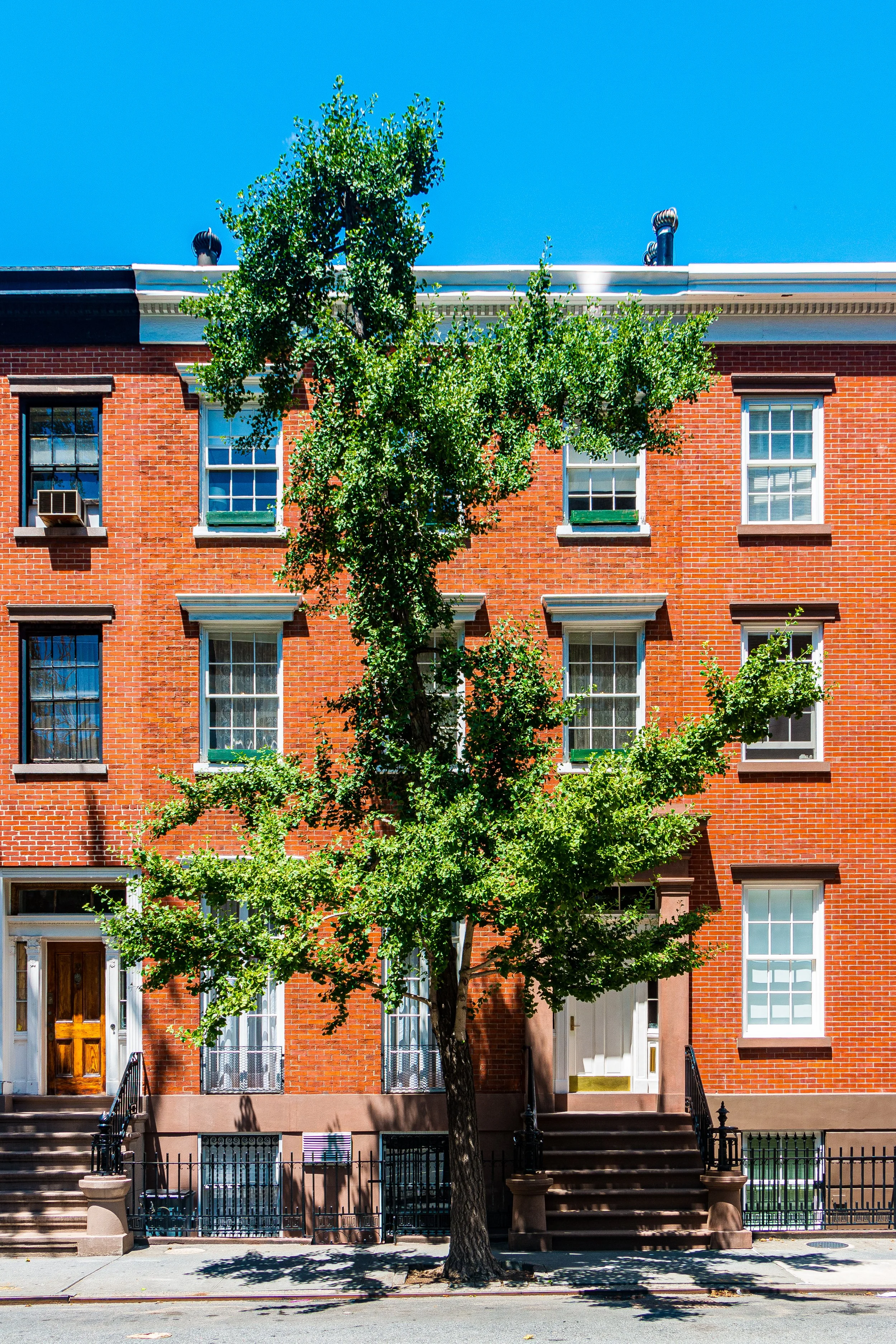
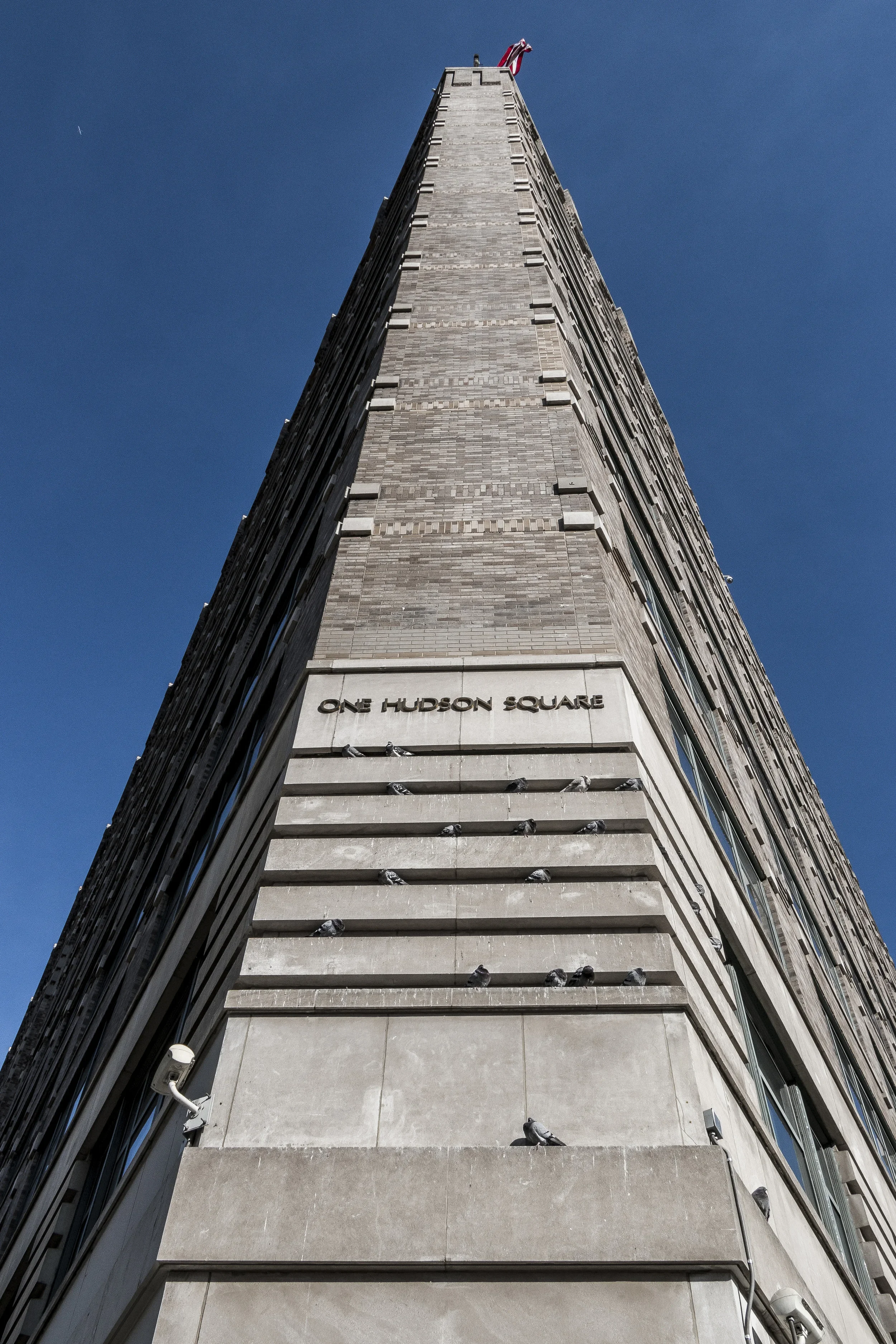
Hudson Square Photographic Tour
Mid-20th Century: Decline and Transition
Like much of the city’s industrial west side, Hudson Square suffered as shipping and manufacturing declined in the 1950s–70s. The piers decayed, and the roar of machinery gave way to vacancy. Yet unlike nearby neighborhoods that faced wholesale demolition, Hudson Square’s sturdy lofts proved too well-built to fall easily.
Artists and small printers began occupying the empty floors, drawn by cheap rents and abundant light. The legacy of craftsmanship endured: sign-painters, typesetters, and photographers coexisted with sculptors and designers. These quiet adaptations laid the groundwork for the neighborhood’s creative rebirth.
Late 20th Century: The Creative Corridor
By the 1990s, the district had become a haven for creative industries — graphic design firms, architecture studios, and independent publishers. The old industrial infrastructure, with its wide floors and freight elevators, perfectly suited modern office life.
Preservationists recognized the area’s unique blend of industrial integrity and historic charm. In 2003, the Charlton–King–Vandam Historic District was officially expanded, ensuring the survival of early Federal rowhouses alongside their 20th-century industrial successors. Meanwhile, the city rezoned portions of the district to encourage mixed-use development, setting the stage for Hudson Square’s next evolution.
21st Century: Media, Design, and Reinvention
Today, Hudson Square stands at the forefront of Manhattan’s creative economy. Former printing plants now house media giants such as WNYC, The New York Magazine Group, and the U.S. headquarters of Google, whose sprawling campus occupies much of the western edge.
New architecture has joined the old with surprising harmony. Glass towers rise beside brick warehouses, while tree-lined pedestrian corridors connect to the Hudson River Park. The revitalized Pier 40, Spring Street Park, and the Hudson River Greenway have transformed the once-industrial waterfront into a recreational frontier.
Amid these changes, traces of the neighborhood’s working past remain visible: the ghosted lettering of defunct printers on brick walls, the rumble of delivery trucks, and the enduring geometry of the cobblestones. Cafés now occupy old loading bays; start-ups operate from rooms that once housed presses. The continuity of making — of ideas instead of ink — defines the district’s modern spirit.
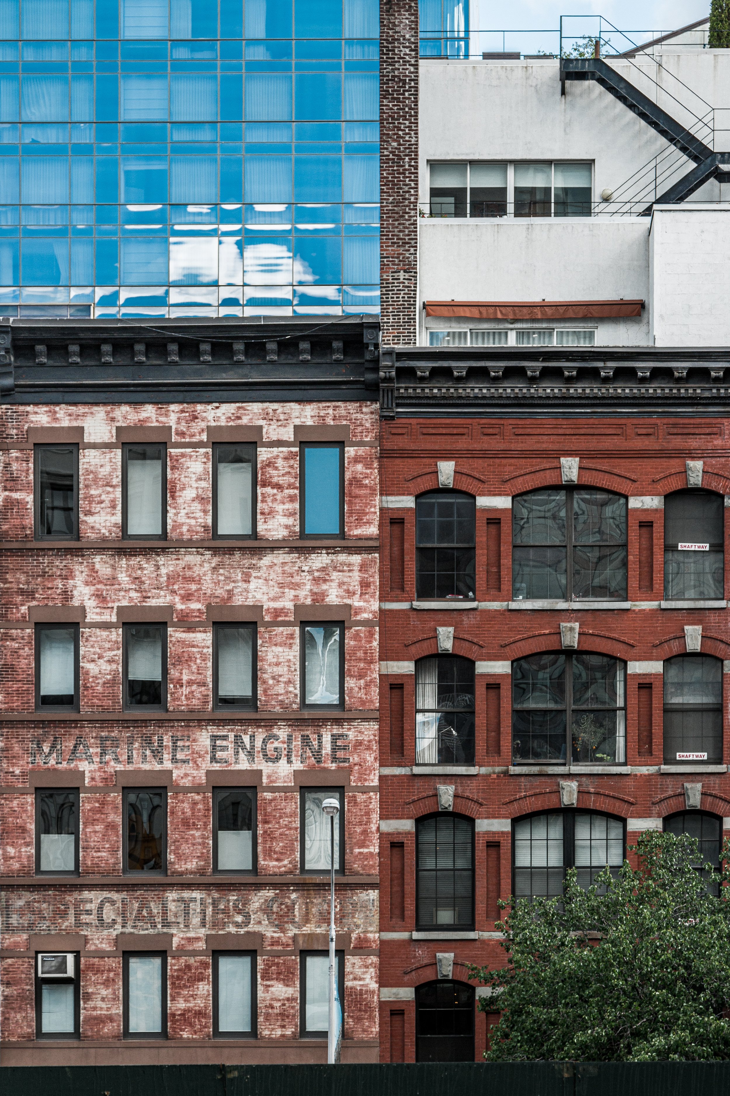
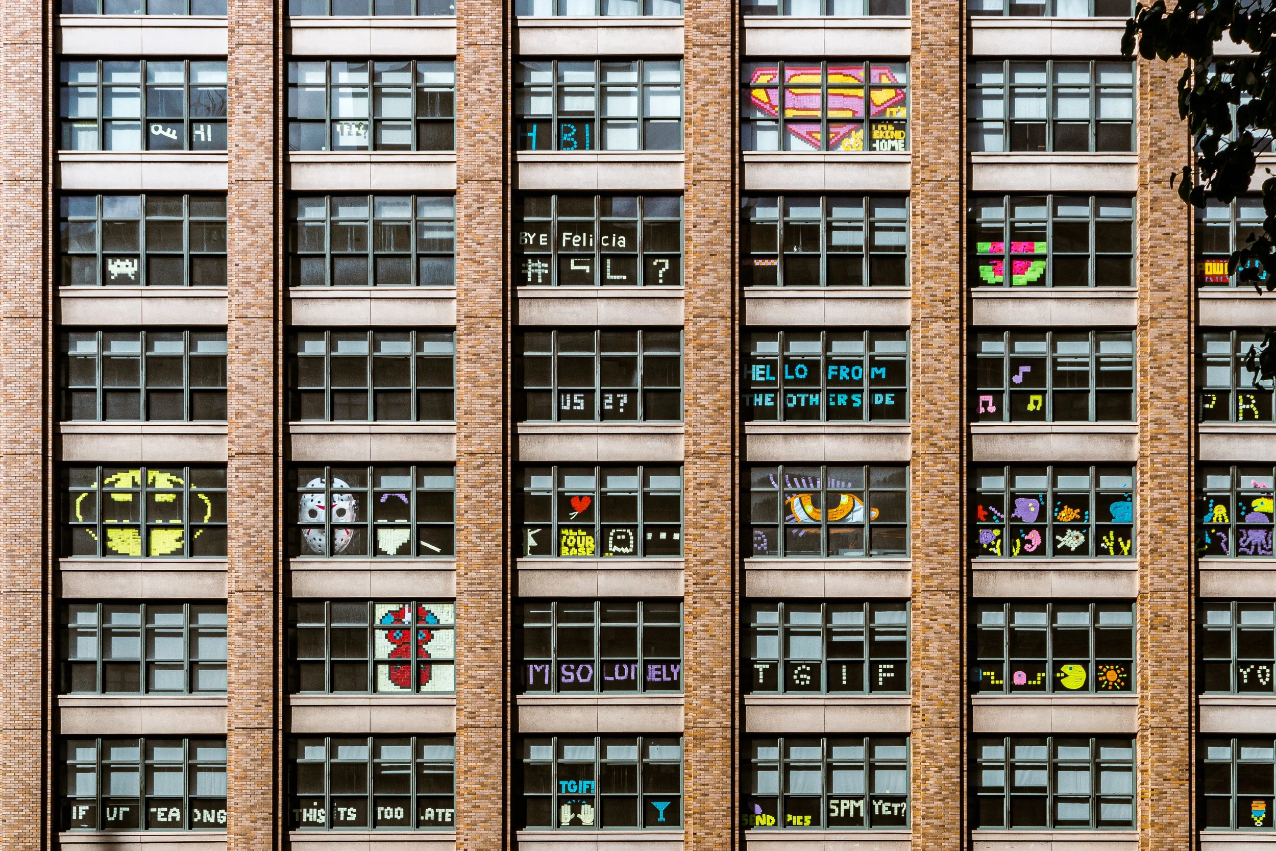
Hudson Square Photo Gallery
Architecture and Atmosphere
Architecturally, Hudson Square is a study in adaptive strength. Early-19th-century Federal rowhouses give way to 20th-century factory lofts and, now, contemporary glass-and-steel expansions. Buildings like the Printing House Lofts (1911) and the Holland Plaza Building (1930) epitomize the district’s industrial grace. The streetscape remains human in scale, its rhythm of brick façades softened by new greenery and public art.
The atmosphere balances energy with restraint. Mornings bring cyclists and commuters crossing Canal Street; afternoons hum with the conversation of designers at sidewalk cafés; evenings glow with reflected light from the river. The air itself feels mixed with history — ink and salt, memory and renewal.
Spirit and Legacy
Hudson Square’s legacy is that of perpetual reinvention without erasure. From marshland to manor, from factory floor to digital studio, it has embodied the city’s capacity to reuse rather than replace, to find beauty in endurance.
New York City
Use this custom Google map to explore where every neighborhood in all five boroughs of New York City is located.
The Five Boroughs
One of New York City’s unique qualities is its organization in to 5 boroughs: Manhattan, Brooklyn, Queens, The Bronx, and Staten Island. These boroughs are part pragmatic administrative districts, and part vestiges of the region’s past. Each borough is an entire county in New York State - in fact, Brooklyn is, officially, Kings County, while Staten Island is, officially Richmond County. But that’s not the whole story …
Initially, New York City was located on the southern tip of Manhattan (now the Financial District) that was once the Dutch colony of New Amsterdam. Across the East River, another city was rising: Brooklyn. In time, the city planners realized that unification between the rapidly rising cities would create commercial and industrial opportunities - through streamlined administration of the region.
So powerful was the pull of unification between New York and Brooklyn that three more counties were pulled into the unification: The Bronx, Queens, and Staten Island. And on January 1, 1898, the City of New York unified two cities and three counties into one Greater City of New York - containing the five boroughs we know today.
But because each borough developed differently and distinctly until unification, their neighborhoods likewise uniquely developed. Today, there are nearly 390 neighborhoods, each with their own histories, cultures, cuisines, and personalities - and each with residents who are fiercely proud of their corner of The Big Apple.


