TODT HILL
Geographic Setting
Bounded by Richmond Road to the southeast, Todt Hill Road to the west, the Staten Island Expressway to the north, Ocean Terrace to the northeast, and Dongan Hills Colony to the southeast, Todt Hill occupies the literal and figurative summit of Staten Island—and indeed, of all five boroughs of New York City. Rising to an elevation of 410 feet above sea level, it is the highest natural point on the Eastern Seaboard south of Maine. The neighborhood’s steep, wooded ridges and winding roads command panoramic views of New York Harbor, the Atlantic Ocean, the Raritan Bay, and the distant skyline of Manhattan.
Geographically, Todt Hill forms the heart of Staten Island’s central highlands, a continuation of the ancient Serpentine Ridge that runs north-south through the island. Its slopes descend westward into the island’s midsection and eastward toward Dongan Hills, providing a landscape of remarkable drama and natural beauty. Today, Todt Hill remains one of Staten Island’s most exclusive residential enclaves—a secluded community of estate-style homes, curving private lanes, and lush woodlands that together preserve the feeling of a mountain retreat within New York City’s bounds.
Etymology
The name Todt Hill originates from the Dutch word “Doodt” or “Todt,” meaning “dead.” Early settlers in the 17th century applied the term—“De Doodt Bergh,” or “the Dead Hill”—possibly referencing a burial ground used by Native Americans or early colonists near the hilltop. Over time, the somber epithet softened to Todt Hill, retaining its Old World resonance while losing its darker connotation.
Another theory links the name to the German word “Tod” (also meaning “death”), a reminder of Staten Island’s early European settlement by Dutch and German families. Regardless of origin, the name has endured through centuries, symbolizing both the hill’s antiquity and its distinction as a place apart—high, quiet, and enduring.
The Neighborhood
Origins through the 19th Century
The earliest history of Todt Hill intertwines with that of Staten Island itself. Before European settlement, the Lenape inhabited these highlands, using the slopes as lookouts over the surrounding bays and waterways. The rich serpentine rock beneath the soil—distinctive for its greenish hue—was quarried by Native peoples and later by colonists for building material.
By the 18th century, Todt Hill was sparsely settled, dotted with farms and woodlots belonging to Dutch and English families. The hill’s elevation made it unsuitable for large-scale agriculture but ideal for timber, grazing, and stone quarrying. During the American Revolution, its heights served as a natural observation point for British forces, who stationed troops here to monitor ship movements in New York Harbor.
Throughout the 19th century, the hill remained largely rural and undeveloped. Wealthy New Yorkers occasionally built summer homes along Richmond Road and Ocean Terrace, drawn by the fresh air and sweeping views. Yet the steep roads and relative isolation kept the area quiet long after neighboring communities like New Dorp and Stapleton had begun to urbanize. Todt Hill’s seclusion would become its greatest asset, preserving its natural contours and forest canopy into the modern era.
Early 20th Century: Estates on the Heights
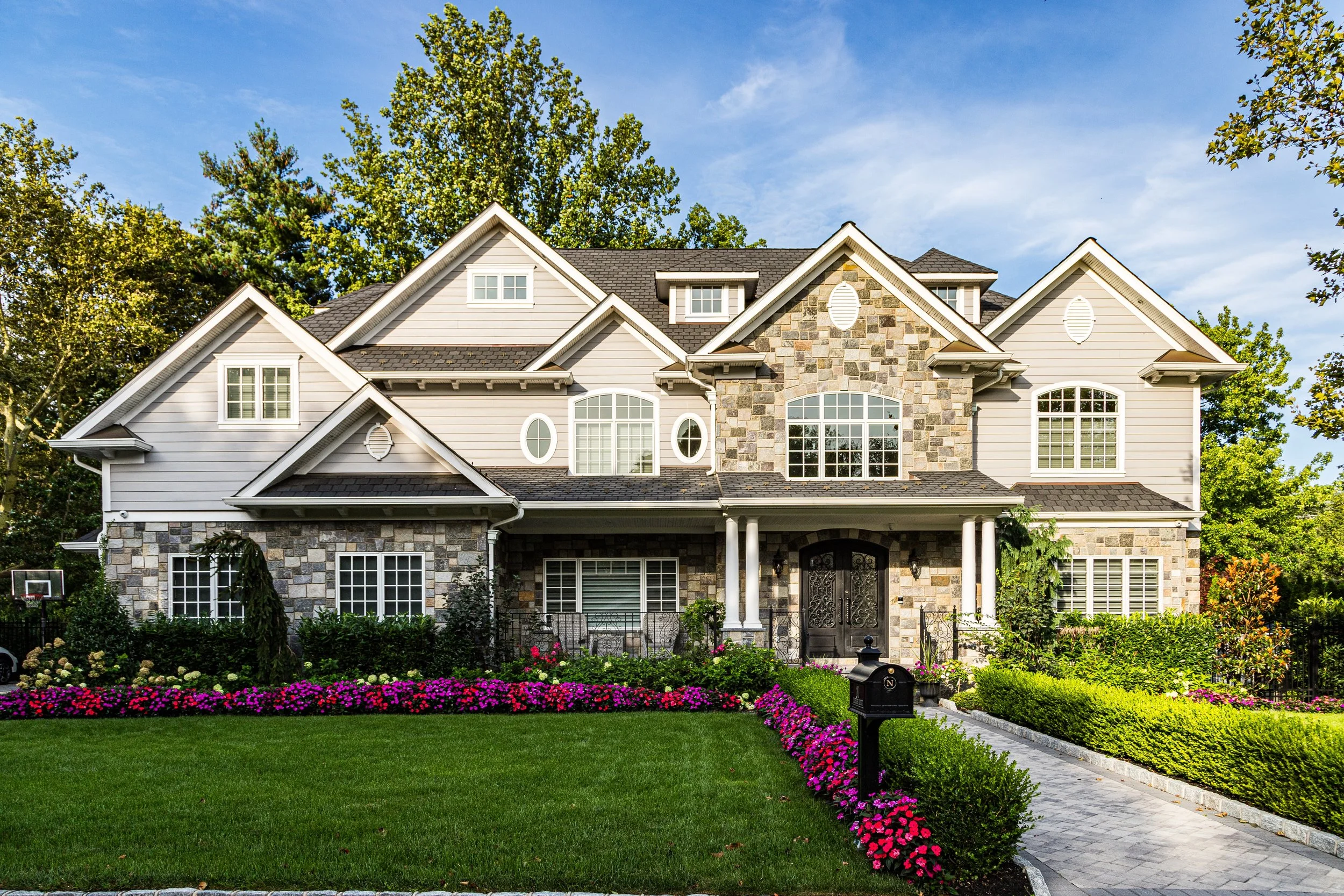
The transformation of Todt Hill into one of Staten Island’s premier residential districts began in the early 1900s. The construction of Todt Hill Road, improved access via Ocean Terrace, and the advent of the automobile made the ridge more reachable from St. George and the ferry. Wealthy families from Manhattan and Brooklyn began to establish estates on its slopes, attracted by the elevation, privacy, and forested beauty.
Architects designed stately homes in Colonial Revival, Tudor, and Mediterranean styles, set back on large lots surrounded by stone walls and mature trees. These homes were not arranged on a traditional grid but rather followed the terrain, emphasizing harmony with the landscape. Private drives, winding lanes, and minimal commercial intrusion gave Todt Hill its distinctive, almost rural character.
At the crest of the hill, the Moravian Cemetery—established in 1740 and expanded over the centuries—became both a historic landmark and a serene green space, with its rolling lawns and mausoleums shaded by ancient oaks. Among its notable residents is Cornelius Vanderbilt, whose family roots on Staten Island stretch back to the colonial era. The presence of the cemetery, coupled with the surrounding forests and estates, gave Todt Hill an enduring sense of peace and continuity.
By the 1930s, Todt Hill had become synonymous with privilege and seclusion. It was often compared to Riverdale in the Bronx or the Palisades across the Hudson—an address that conveyed both distinction and retreat.
Mid–Late 20th Century: Suburban Elegance and Conservation
The mid-20th century brought change to Staten Island, but Todt Hill retained its aura of refinement and restraint. As the Verrazzano-Narrows Bridge (1964) spurred massive suburban growth across the island, Todt Hill’s zoning and geography prevented overdevelopment. The area’s winding roads and steep grades discouraged mass construction, preserving its low density and wooded landscape.
During this period, many of the grand early-20th-century estates were renovated or subdivided into smaller but still substantial homes. Architectural styles diversified—ranch houses and modernist villas appeared beside older Tudor manors—but the overall scale remained generous, with deep setbacks and landscaped grounds. The Richmond County Country Club, located on the western slope of Todt Hill, emerged as one of the borough’s social and recreational hubs, offering golf, tennis, and dining within minutes of residents’ homes.
Environmental preservation gained prominence as the surrounding forests became part of the Staten Island Greenbelt, a vast network of parks, trails, and natural areas that includes High Rock Park and Latourette Park. These protected lands ensured that Todt Hill would remain enveloped in greenery even as Staten Island urbanized around it.
By the 1980s, Todt Hill had firmly established its reputation as Staten Island’s most prestigious address—a symbol of quiet affluence, natural beauty, and old New York elegance.
21st Century: Prestige, Preservation, and Perch Above the City
In the 21st century, Todt Hill continues to embody both exclusivity and ecological balance. Its streets—lined with luxury homes, manicured lawns, and stone gateways—retain a timeless calm, while the surrounding forests and parks reinforce its connection to nature. Many of the area’s historic estates have been carefully restored, and new construction often reflects traditional design sensibilities to blend with the neighborhood’s established character.
Residents enjoy easy access to Richmond Road’s amenities, the Staten Island Expressway, and the cultural institutions of St. George, yet Todt Hill remains strikingly insulated from the city’s bustle. Its quiet lanes, some without sidewalks, and its absence of commercial centers preserve the sense of seclusion that has defined it since its earliest days.
The neighborhood’s elevation still shapes its experience: winters bring more snow, summers more breeze, and every season offers views of the harbor and skyline unseen from elsewhere in the city. Civic and environmental organizations remain active in protecting both the natural and architectural integrity of the hill, emphasizing sustainability, tree preservation, and landscape design that respects the ridge’s ecology.
Modern Todt Hill is not a place of spectacle but of understatement—a community defined by discretion, continuity, and its deep relationship to the land.
Spirit and Legacy
The spirit of Todt Hill lies in its height—not merely its elevation, but its perspective. It stands above the city both literally and symbolically, a place where the natural world still shapes human habitation. Its legacy is one of endurance: of forests and stone, of estates and trails, of a community that has valued preservation over progress for its own sake.
From its Dutch name to its skyline views, Todt Hill embodies Staten Island’s layered history—a meeting of old-world settlement, natural grandeur, and modern refinement. The hill’s winding roads, shaded by centuries-old trees, echo the same solitude that drew settlers here three hundred years ago.
New York City
Use this custom Google map to explore where every neighborhood in all five boroughs of New York City is located.
The Five Boroughs
One of New York City’s unique qualities is its organization in to 5 boroughs: Manhattan, Brooklyn, Queens, The Bronx, and Staten Island. These boroughs are part pragmatic administrative districts, and part vestiges of the region’s past. Each borough is an entire county in New York State - in fact, Brooklyn is, officially, Kings County, while Staten Island is, officially Richmond County. But that’s not the whole story …
Initially, New York City was located on the southern tip of Manhattan (now the Financial District) that was once the Dutch colony of New Amsterdam. Across the East River, another city was rising: Brooklyn. In time, the city planners realized that unification between the rapidly rising cities would create commercial and industrial opportunities - through streamlined administration of the region.
So powerful was the pull of unification between New York and Brooklyn that three more counties were pulled into the unification: The Bronx, Queens, and Staten Island. And on January 1, 1898, the City of New York unified two cities and three counties into one Greater City of New York - containing the five boroughs we know today.
But because each borough developed differently and distinctly until unification, their neighborhoods likewise uniquely developed. Today, there are nearly 390 neighborhoods, each with their own histories, cultures, cuisines, and personalities - and each with residents who are fiercely proud of their corner of The Big Apple.
